| During the month of April, Mark Miller will donate $75 to the charity of your choice (5 to chose from, including the Utah Avalanche Center!) Mark Miller Subaru has raised over $300k in the previous 6 Do Good Feel Good events. More Info here |  |
| During the month of April, Mark Miller will donate $75 to the charity of your choice (5 to chose from, including the Utah Avalanche Center!) Mark Miller Subaru has raised over $300k in the previous 6 Do Good Feel Good events. More Info here | |
| Advisory: Provo Area Mountains | Issued by Bruce Tremper for Friday - January 9, 2015 - 7:01am |
|---|


|
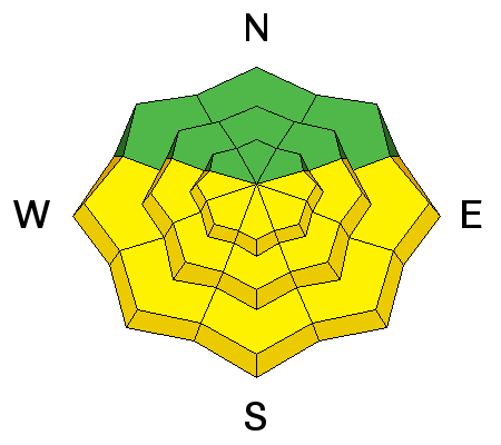
bottom line There are lingering pockets of MODERATE danger of wet avalanches on the sun exposed slopes today (that face generally the south half of the compass). Also be cautious of glide avalanche areas such as steep, rock slabs. There are still isolated places on upper elevation slopes facing northwest through east where a person could trigger a deeper, more dangerous slide failing on faceted snow or depth hoar, creating a pockety MODERATE danger.
|
 |
special announcement Happy Birthday to Brett Kobernik aka Kobwoy! |
 |
current conditions The free air temperatures have finally dropped below freezing for the first time in several days. Snow surface temperature is controlled more by radiation than air temperature. So even though the clear skies allow outgoing longwave (heat) radiation to thinly freeze the snow surface, the air temperature has been above freezing for several days. In other words, the snow surface should be icy and crunchy this morning in most places with at least a better refreeze. There's still some soft, very dense, settled, dry snow on northerly facing slopes at upper elevations but the popular areas have lots of tracks. Today should be the last clear day for several days so enjoy it while you can.
This is a 2-day plot with the present time on the right. |
 |
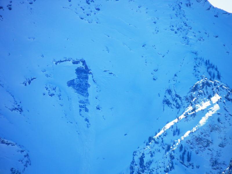
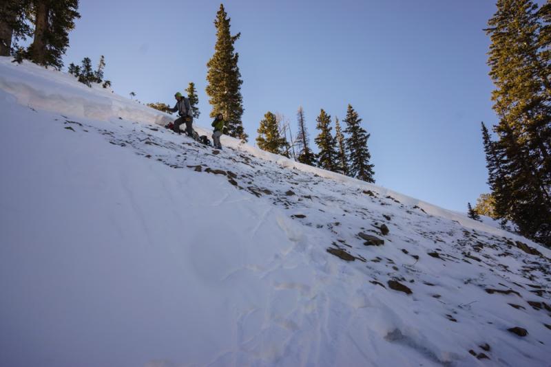
recent activity A large glide avalanche released in the Salt Lake area mountains in Broad's Fork probably on Wednesday night and several folks sent us photos yesterday. We also continue to hear about wet activity that occurred probably Wednesday and just some continued minor sluffing and rollerballs yesterday.
Photo: Mark White Also, yesterday we investigated a skier triggered avalanche on Peak 10,420 near Brighton that occurred on Sunday but we only learned about it yesterday. It was quite eye opening. HERE is our report complete with a video if you're interested.
|
| type | aspect/elevation | characteristics |
|---|

|
|
LIKELIHOOD
 LIKELY
UNLIKELY
SIZE
 LARGE
SMALL
TREND
 INCREASING DANGER
SAME
DECREASING DANGER
|
|
description
Although temperatures have cooled at least 10 degrees from the sweltering heat on Wednesday, we may still see some lingering pockets wet activity. Especially watch for more glide avalanches like we saw in Broad's Fork, which probably occurred Wednesday night. Glide avalanches paradoxically tend to release more often after the snow surface freezes after a strong thaw--conditions like right now. So be cautious of the usual glide avalanche areas on steep rock slabs. |
| type | aspect/elevation | characteristics |
|---|

|

|
LIKELIHOOD
 LIKELY
UNLIKELY
SIZE
LARGE
SMALL
TREND
 INCREASING DANGER
SAME
DECREASING DANGER
|
|
description
We have not seen a persistent slab release since Tuesday so perhaps I'm overreacting to keep mentioning it. But as our investigation of the Peak 10,420 slide yesterday revealed, there is still lots of thin weak snow out there that I don't trust. Perhaps it's just because I grew up in Montana where people sometimes inadvertently roust a hibernating grizzly bear in the winter. Just sayin....
|
 |
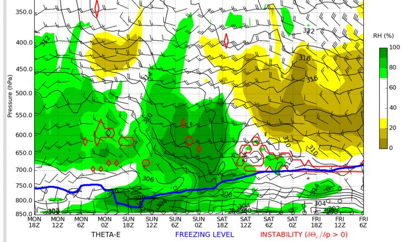
weather Today will be the last sunny, warm day for the next several days so enjoy it while you can. Temperatures have cooled 10 degrees since Wednesday and they hover just below freezing in most mountain areas. Wind remains light. We have a weak system that should arrive on Saturday morning with clouds and a few light snow showers and it should continue through about Tuesday when we have a better chance of snow. Total snow by Tuesday will likely add up to around 6 inches. Hopefully, it will blow out the smog in the valleys. The extended forecast after Tuesday calls for a return to sunny weather but not as hot as the high pressure ridge this past week.
If you want to get geeky, I'm quite addicted to these time-height sections from the University of Utah. Time is on the horizontal axis (present time on the right) and height on the vertical axis (the highest peaks are around 600 mb). The green color are clouds. This shows the weak storm forecasted for us over the next several days. |
| general announcements Remember your information can save lives. If you see anything we should know about, please participate in the creation of our own community avalanche advisory by submitting snow and avalanche conditions. You can also call us at 801-524-5304, email by clicking HERE, or include #utavy in your tweet or Instagram. If you trigger an avalanche in the backcountry - especially if you are adjacent to a ski area – please call the following teams to alert them to the slide and whether anyone is missing or not. Rescue teams can be exposed to significant hazard when responding to avalanches, and do not want to do so when unneeded. Thanks. Salt Lake and Park City – Alta Central (801-742-2033), Canyons Resort Dispatch (435-615-3322) Snowbasin Resort Dispatch (801-620-1017), Powder Mountain Dispatch (801-745-3772 x 123). Sundance Dispatch (801-223-4150) EMAIL ADVISORY If you would like to get the daily advisory by email you will need to subscribe here. DAWN PATROL Hotline updated daily by 5-530am - 888-999-4019 option 8. Twitter Updates for your mobile phone - DETAILS UDOT canyon closures: LINK TO UDOT, or on Twitter, follow @UDOTavy, @CanyonAlerts or @AltaCentral Utah Avalanche Center mobile app - Get your advisory on your iPhone along with great navigation and rescue tools. Wasatch Powderbird Guides Blog/Itinerary for the Day. Lost or Found something in the backcountry? - http://nolofo.com/ Discount lift tickets are now available at Backcountry.com with more resorts to come soon. Thanks to Ski Utah and the Utah Resorts. All proceeds go towards paying for Utah Avalanche Center avalanche and mountain weather advisories. To those skinning uphill at resorts: it is your responsibility to know the resort policy on uphill travel. You can see the uphill travel policy for each resort here. IMPORTANT: Before skinning or hiking at a resort under new snow conditions, check in with Ski Patrol. Resorts can restrict or cut off access if incompatible with control and grooming operations. Benefit the Utah Avalanche Center when you shop from Backcountry.com or REI: Click this link for Backcountry.com or this link to REI, shop, and they will donate a percent of your purchase price to the UAC. Both offer free shipping (with some conditions) so this costs you nothing! Benefit the Utah Avalanche Center when you buy or sell on ebay - set the Utah Avalanche Center as a favorite non-profit in your ebay account here and click on ebay gives when you buy or sell. You can choose to have your seller fees donated to the UAC, which doesn't cost you a penny. This information does not apply to developed ski areas or highways where avalanche control is normally done. This advisory is from the U.S.D.A. Forest Service, which is solely responsible for its content. This advisory describes general avalanche conditions and local variations always exist. |


_3.jpg)