| During the month of April, Mark Miller will donate $75 to the charity of your choice (5 to chose from, including the Utah Avalanche Center!) Mark Miller Subaru has raised over $300k in the previous 6 Do Good Feel Good events. More Info here |  |
| During the month of April, Mark Miller will donate $75 to the charity of your choice (5 to chose from, including the Utah Avalanche Center!) Mark Miller Subaru has raised over $300k in the previous 6 Do Good Feel Good events. More Info here | |
| Advisory: Provo Area Mountains | Issued by Drew Hardesty for Monday - November 24, 2014 - 7:31am |
|---|

|
bottom line The season has hardly begun but we have a CONSIDERABLE AVALANCHE DANGER. Steep backcountry terrain should be avoided. The danger is most pronounced on upper elevation slopes facing northwest through north through east, where the snow is landing on the weak pre-existing snow. REMEMBER it is possible to trigger an avalanche while skiing or riding below the steep slope. 'EXPERTS ONLY' - All the experts I know are staying on low angle terrain with nothing steeper above.
|
 |
avalanche warning The Avalanche Warning for all the mountains of northern Utah will continue through midweek. Dangerous avalanche conditions exist at the mid and upper elevations, with both natural and human triggered slides likely. The danger is most pronounced in the Central Wasatch. This warning does not include ski areas or highways where avalanche control is normally done. |
 |
special announcement
|
 |
current conditions It's still snowing. Storm totals as of 5am are -
Temps are in the teens and the winds are starting to ramp up - blowing from the west to northwest blowing 20-30mph with gusts into the 40s. |
 |
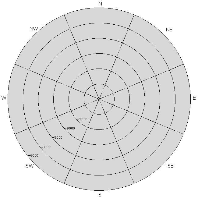
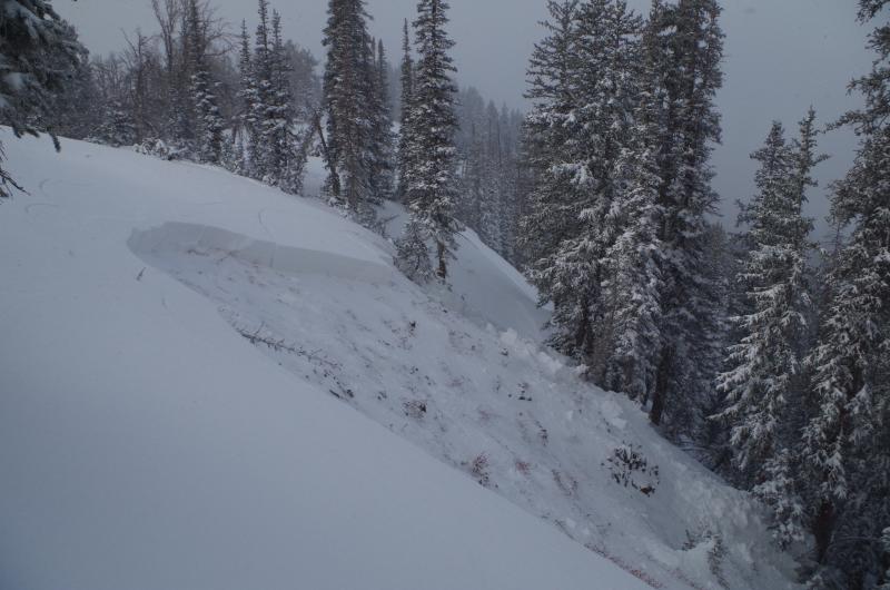
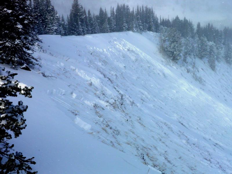
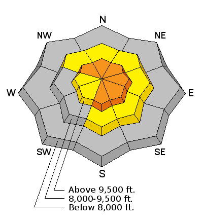
recent activity We didn't hear of any avalanches in the Provo mountains, but this no doubt is due to fewer people in the high terrain. In the central Wasatch, it was "game-on". Almost too many avalanches to report. (Click here to see the avalanche list). A natural cycle occurred in the early to mid-morning hours yesterday during the height of the snowfall intensity, but then nearly everyone that ventured out into the backcountry reported action. Control teams at the mountain resorts reported very sensitive conditions on a variety of aspects and elevations as well. Most of the avalanches reported in the backcountry were remotely triggered (triggered at a distance) from a safe spot on a a ridgeline, with many of them stepping 2-3' deep to the ground, and some up to 500' wide. Shooting cracks and whumphing/collapsing were the rule and not the exception. The backcountry avalanches were predominantly on north to east facing slopes above about 9300' (see aspect/elevation rose below) though collapsing was noted in the drainages as well. Photos (Jordan, White, below)
|
| type | aspect/elevation | characteristics |
|---|

|
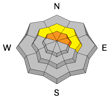
|
LIKELIHOOD
 LIKELY
UNLIKELY
SIZE
 LARGE
SMALL
TREND
 INCREASING DANGER
SAME
DECREASING DANGER
|
|
description
While these avalanches will not be as sensitive as they were yesterday, continued wind and snow loading will keep them primed for activity. Many can still be triggered remotely from a distance. This is a key concept - you may be able to trigger the 2-3' tree snapper from lower angle slopes below and pull the rug down on top of you. Similarly - as some of these slides are becoming increasing connected (400-600' wide), they may be wrapping into adjacent lower angle terrain. Terrain recommendations remain the same - avoid being on, adjacent to, or below any steep west to north to east facing slope. More info can be found by clicking the 'i' button next to the Persistent Slab icon. |
| type | aspect/elevation | characteristics |
|---|

|
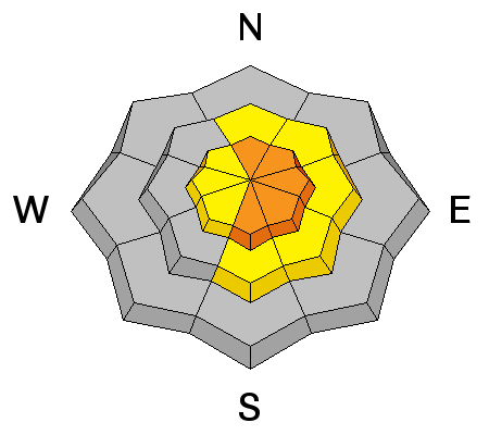
|
LIKELIHOOD
LIKELY
UNLIKELY
SIZE
LARGE
SMALL
TREND
INCREASING DANGER
SAME
DECREASING DANGER
|
|
description
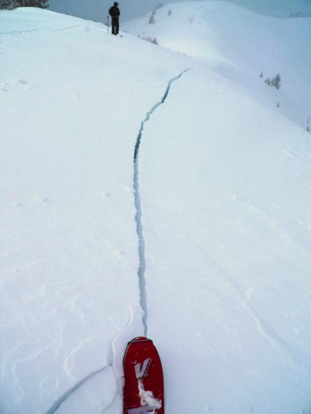
You will find wind drifts scattered all over – on a variety of elevations and aspects. You will be most likely to trigger a drift where it is sitting on sugary old snow, but drifts should be avoided on all steep slopes. Shooting cracks are a dead give-away (see Mark White photo below). These drifts can be rounded, scalloped, and hollow sounding.
More info can be found by clicking the 'i' button next to the Wind Slab icon. |
 |
weather Light to moderate snowfall will continue for a few more hours this morning, before becoming partly cloudy by midday to early afternoon. Winds will remain moderate to strong out of the west and northwest. A warm air advection pattern sets up through late Tuesday where we'll see mountain temps warm into the upper 20s, searing west to northwest winds in the 45-50mph range with gusts to 70+, a couple soggy inches, and rime. High pressure builds for mid to late week with perhaps another storm for the weekend. |
| general announcements
Remember your information can save lives. If you see anything we should know about, please participate in the creation of our own community avalanche advisory by submitting snow and avalanche conditions. You can also call us at 801-524-5304, email by clicking HERE, or include #utavy in your tweet or Instagram. If you trigger an avalanche in the backcountry - especially if you are adjacent to a ski area – please call the following teams to alert them to the slide and whether anyone is missing or not. Rescue teams can be exposed to significant hazard when responding to avalanches, and do not want to do so when unneeded. Thanks. Salt Lake and Park City – Alta Central (801-742-2033), Canyons Resort Dispatch (435-615-3322) Snowbasin Resort Dispatch (801-620-1017), Powder Mountain Dispatch (801-745-3772 x 123). Sundance Dispatch (801-223-4150) EMAIL ADVISORY If you would like to get the daily advisory by email you will need to subscribe here. DAWN PATROL Hotline updated daily by 5-530am - 888-999-4019 option 8. Twitter Updates for your mobile phone - DETAILS UDOT canyon closures: LINK TO UDOT Utah Avalanche Center mobile app - Get your advisory on your iPhone along with great navigation and rescue tools. Wasatch Powderbird Guides Blog/Itinerary for the Day. Lost or Found something in the backcountry? - http://nolofo.com/ Discount lift tickets will soon be available at Backcountry.com - Thanks to Ski Utah and the Utah Resorts. All proceeds go towards paying for Utah Avalanche Center avalanche and mountain weather advisories. To those skinning uphill at resorts: it is your responsibility to know the resort policy on uphill travel. You can see the uphill travel policy for each resort here. IMPORTANT: Before skinning or hiking at a resort under new snow conditions, check in with Ski Patrol. Resorts can restrict or cut off access if incompatible with control and grooming operations. Benefit the Utah Avalanche Center when you shop from Backcountry.com or REI: Click this link for Backcountry.com or this link to REI, shop, and they will donate a percent of your purchase price to the UAC. Both offer free shipping (with some conditions) so this costs you nothing! Benefit the Utah Avalanche Center when you buy or sell on ebay - set the Utah Avalanche Center as a favorite non-profit in your ebay account here and click on ebay gives when you buy or sell. You can choose to have your seller fees donated to the UAC, which doesn't cost you a penny. This information does not apply to developed ski areas or highways where avalanche control is normally done. This advisory is from the U.S.D.A. Forest Service, which is solely responsible for its content. This advisory describes general avalanche conditions and local variations always exist. |


_3.jpg)