
| During the month of April, Mark Miller will donate $75 to the charity of your choice (5 to chose from, including the Utah Avalanche Center!) Mark Miller Subaru has raised over $300k in the previous 6 Do Good Feel Good events. More Info here |  |
| During the month of April, Mark Miller will donate $75 to the charity of your choice (5 to chose from, including the Utah Avalanche Center!) Mark Miller Subaru has raised over $300k in the previous 6 Do Good Feel Good events. More Info here | |
| Advisory: Provo Area Mountains | Issued by Evelyn Lees for Wednesday - March 26, 2014 - 7:01am |
|---|

|
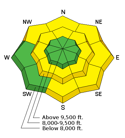
bottom line The AVALANCHE DANGER is MODERATE for human triggered wet avalanches today, especially at the low and mid elevations. Avoid steep slopes with new or old wet soggy snow, or that are “punchy”- where you are breaking through a thin frozen crust into wet snow. If you are in an area that receives more than about 6” of new snow combined with wind, it may be possible to trigger a few new wind drifts. These would be on upper elevation, northeast through southeasterly facing slopes.
|
 |
special announcement This Thursday, Mar 27th, Liam Fitzgerald will be the final speaker at the Utah Adventure Journal series, talking about avalanche control in Little Cottonwood Canyon and the avalanche control program in the early days of Snowbird. Liam was the first snow safety director at Snowbird and has been an avalanche professional in Little Cottonwood ever since. Liam will be sharing stories and lessons learned from avalanche assessment and control over 45 years. There is a suggested small donation to the Utah Avalanche Center which includes a raffle for great donated gear and happy hour food and drink specials. 6pm, Wildflower Lounge, 21+ Thanks for all the love during last Thursday's Love Utah Give Utah Campaign. 97 of you came forward with $4,145 which will help plug some holes in our advisory and education programs next season plus make some website improvements over the summer. Thanks for the notes and best wishes - SALE! on all remaining discount lift tickets donated to the Utah Avalanche Center from Snowbasin, the Canyons, Beaver Mountain, Sundance, and Brian Head: The few remaining tickets are being blown out with all proceeds used to pay for avalanche advisories and education. Go here to get your tickets. |
 |
current conditions A cold front is sliding across northern Utah this morning, and the sweltering overnight temperatures are finally starting to cool. It’s now below freezing at 10,000’, though most mid and lower elevation stations are still in the mid-30s to mid-40s. The southerly winds were briefly strong ahead of the front, but have shifted to a more westerly direction and are decreasing. Average wind speeds are now in the 10 to 20 mph range, though it’s still gusting to 40 mph across the higher ridgelines. Light snow should be developing by mid-morning. |
 |
recent activity The only avalanche activity reported yesterday were a few wet loose slides. Below are the most recent Provo area observations.
|
| type | aspect/elevation | characteristics |
|---|

|

|
LIKELIHOOD
 LIKELY
UNLIKELY
SIZE
 LARGE
SMALL
TREND
 INCREASING DANGER
SAME
DECREASING DANGER
|
|
description
Very warm temperatures overnight and slow cooling today means that triggering wet avalanches is still a concern. Wet loose sluffs could be triggered today on steep slopes where the snow is still warm and soggy. Also, the few inches of new snow we receive today will gain heat from the old snow, so new snow wet sluffs will also be possible on some slopes. In addition, other wet snow concerns include:
|
 |
weather The first front of a multi-part storm crossed northern Utah this morning. Temperatures are starting to drop, and winds have shifted to a more westerly direction and decreased. Speeds at most stations should remain in the 15 to 20 mph range. Wind speeds along the high ridgelines should settle down into the 20 to 30 mph range, gusting into the 40s. 10,000’ temperatures should slowly cool into the low to mid 20s by this afternoon. Snow should develop mid to late morning, and continue through the afternoon, with 2 to 5” possible today. There is a 25% chance of lightening this afternoon. There will be a lull overnight, with a few snow showers possible; then the strongest portion of the storm will arrive early tomorrow morning. An additional 3 to 6” of snow will be possible on Thursday. |
| general announcements Remember your information can save lives. If you see anything we should know about, please participate in the creation of our own community avalanche advisory by submitting snow and avalanche conditions. You can also call us at 801-524-5304 or 800-662-4140, email by clicking HERE, or include #utavy in your tweet or Instagram. If you trigger an avalanche in the backcountry - especially if you are adjacent to a ski area – please call the following teams to alert them to the slide and whether anyone is missing or not. Rescue teams can be exposed to significant hazard when responding to avalanches, and do not want to do so when unneeded. Thanks. Salt Lake and Park City – Alta Central (801-742-2033), Canyons Resort Dispatch (435-615-3322) Snowbasin Resort Dispatch (801-620-1017), Powder Mountain Dispatch (801-745-3772 x 123). Sundance Dispatch (801-223-4150) EMAIL ADVISORY We have switched to a new SLC email advisory system. If you would like to get the daily advisory by email, or if you have been getting the advisory by email since the beginning of the season and wish to continue, you will need to subscribe here. DAWN PATROL Hotline updated daily by 5-530am - 888-999-4019 option 8. Twitter Updates for your mobile phone - DETAILS UDOT canyon closures: LINK TO UDOT Utah Avalanche Center mobile app - Get your advisory on your iPhone along with great navigation and rescue tools.uned. Wasatch Powderbird Guides Blog/Itinerary for the Day. Lost or Found something in the backcountry? - http://nolofo.com/ Discount lift tickets are now available at Backcountry.com - Thanks to Ski Utah and the Utah Resorts. All proceeds go towards paying for Utah Avalanche Center avalanche and mountain weather advisories. To those skinning uphill at resorts: it is your responsibility to know the resort policy on uphill travel. Some allow uphill travel and have guidelines, some don't. Contact the Ski Patrol at each resort for details. IMPORTANT: Before skinning at a resort under new snow conditions, check in with Ski Patrol. Resorts can restrict or cut off access if incompatible with control and grooming operations. Benefit the Utah Avalanche Center when you shop from Backcountry.com or REI: Click this link for Backcountry.com or this link to REI, shop, and they will donate a percent of your purchase price to the UAC. Both offer free shipping (with some conditions) so this costs you nothing! Benefit the Utah Avalanche Center when you buy or sell on ebay - set the Utah Avalanche Center as a favorite non-profit in your ebay account here and click on ebay gives when you buy or sell. You can choose to have your seller fees donated to the UAC, which doesn't cost you a penny. This information does not apply to developed ski areas or highways where avalanche control is normally done. This advisory is from the U.S.D.A. Forest Service, which is solely responsible for its content. This advisory describes general avalanche conditions and local variations always exist. |


_3.jpg)