| During the month of April, Mark Miller will donate $75 to the charity of your choice (5 to chose from, including the Utah Avalanche Center!) Mark Miller Subaru has raised over $300k in the previous 6 Do Good Feel Good events. More Info here |  |
| During the month of April, Mark Miller will donate $75 to the charity of your choice (5 to chose from, including the Utah Avalanche Center!) Mark Miller Subaru has raised over $300k in the previous 6 Do Good Feel Good events. More Info here | |
| Advisory: Provo Area Mountains | Issued by Evelyn Lees for Wednesday - March 19, 2014 - 7:06am |
|---|


|
bottom line The AVALANCHE DANGER is mostly LOW early this morning, with a MODERATE DANGER on steep north through easterly facing slopes where a thin buried wind slab exists or new wind drifts may form this afternoon. The avalanche danger will rise to MODERATE for wet slides as the day heats up.
|
 |
special announcement SALE! on all remaining discount lift tickets donated to the Utah Avalanche Center from Beaver Mountain, Wolf Mountain, Sundance, and Brian Head: The few remaining tickets are being blown out with all proceeds used to pay for avalanche advisories and education. Go here to get your tickets. Can you change Utah in a day? Utah's non-profit community is a big part of what makes living in Utah great. Join your community in a state-wide day of non-profit appreciation and support with Love Utah Give Utah on Thursday, March 20. Your donation to the Utah Avalanche Center between now and March 20 through this link, large or small, helps pay for avalanche advisories and education and makes the Utah Avalanche Center eligible for challenge grants and special awards provided by local businesses. In Salt Lake City? Stop by Squatters downtown on Thursday 3/20 between 4 and 6 for some free snacks, an opportunity to chat with some of the UAC folks, and make an online donation. Free Utah Adventure Journal Speaker Series: March 20 at 6pm: DENNIS TURVILLE: History, first decent stories and modern impacts-A History of Canyoneering at the Wildflower Lounge at Snowbird with a raffle to benefit the Utah Avalanche Center. 21+ |
 |
current conditions It’s a cold, crisp morning with amazingly calm winds. Temperatures at all elevations are in the single digits to mid-teens, and the northwesterly winds are barely a whisper – averaging 10 mph or less at almost all stations. Storm totals from Monday night were about a foot along the high ridges of upper Little Cottonwood, with 5-8” in Big Cottonwood, on the Park City side and in the Ogden area mountains. Provo was a bit too far south, and received only an inch. |
 |
recent activity There are no recent reports form the Provo area mountains. Yesterday’s reports from the backcountry and resorts of the SL, PC and Ogden area mountains were of mostly stable snow, with a few minor sluffs and shallow soft slabs being triggered. However, the outlier was reports of large collapses and poor structure on some upper elevation, east facing slopes, especially on Cardiac Ridge, an upper elevation slope in Big Cottonwood. |
| type | aspect/elevation | characteristics |
|---|

|

|
LIKELIHOOD
 LIKELY
UNLIKELY
SIZE
 LARGE
SMALL
TREND
 INCREASING DANGER
SAME
DECREASING DANGER
|
|
description
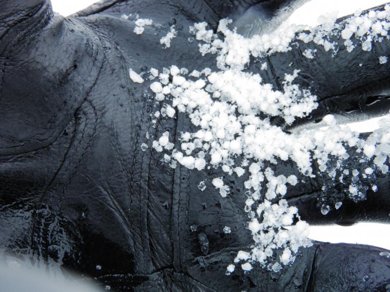
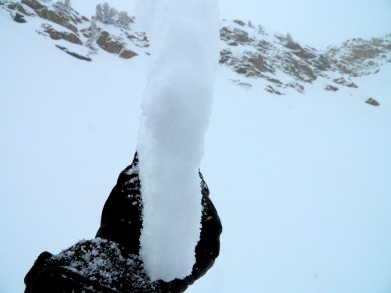
This layering may or may not exist in the Provo area mountains, but if it does, it would be on mid to upper elevation slopes. The strong Monday winds left behind a shallow wind slab early in the storm, subsequently buried beneath the light powder. This buried wind slab (crust) is collapsing on the old snow beneath. While this poor structure was also noted on northerly facing slopes, most of the reports of collapsing were confined to easterly facing slopes. While no slides were triggered on this layer, it is definitely suspect on steep slopes. mark White photos below - quick pit hand pit showing failure below wind slab; grauple weak layer; wind slab.
A second set of wind slabs may be created today as the winds pick up slightly this afternoon, and drift the light powder. These soft new drifts will be primarily confined to the higher ridge lines. And a final wind created issue – sensitive cornices. It was easy to get big chunks of cornice to fail yesterday, and cornices often have a habit of breaking back further than one would expect. |
| type | aspect/elevation | characteristics |
|---|

|
|
LIKELIHOOD
 LIKELY
UNLIKELY
SIZE
LARGE
SMALL
TREND
 INCREASING DANGER
SAME
DECREASING DANGER
|
|
description
Temperatures will take a huge jump today, and combined with strong sun, wet sluffs are expected on first on east facing slopes, then south, then west to northwest facing slopes.
It is basically an avoidance issue - as the snow becomes damp today, get off of and out from under steep slopes fast! Switch to another, cooler aspect, lower angle slopes, or head home for the day. |
 |
weather With high pressure in firm control, there will be abundant sunshine and unusually light winds today. Temperatures at 10,000’ will rapidly warm into the mid-20s by this afternoon, and into the mid-30s at 8,000’. The northwesterly winds will shift to the southwest, and increase slightly by this afternoon – to 20 mph averages, with gusts to 30 along the highest ridgelines. It’s a mostly quiet weather week ahead, with a dry cold front crossing the area on Thursday evening, and another weak front around Saturday. |
| general announcements Remember your information can save lives. If you see anything we should know about, please participate in the creation of our own community avalanche advisory by submitting snow and avalanche conditions. You can also call us at 801-524-5304 or 800-662-4140, email by clicking HERE, or include #utavy in your tweet or Instagram. If you trigger an avalanche in the backcountry - especially if you are adjacent to a ski area – please call the following teams to alert them to the slide and whether anyone is missing or not. Rescue teams can be exposed to significant hazard when responding to avalanches, and do not want to do so when unneeded. Thanks. Salt Lake and Park City – Alta Central (801-742-2033), Canyons Resort Dispatch (435-615-3322) Snowbasin Resort Dispatch (801-620-1017), Powder Mountain Dispatch (801-745-3772 x 123). Sundance Dispatch (801-223-4150) EMAIL ADVISORY We have switched to a new SLC email advisory system. If you would like to get the daily advisory by email, or if you have been getting the advisory by email since the beginning of the season and wish to continue, you will need to subscribe here. DAWN PATROL Hotline updated daily by 5-530am - 888-999-4019 option 8. Twitter Updates for your mobile phone - DETAILS UDOT canyon closures: LINK TO UDOT Utah Avalanche Center mobile app - Get your advisory on your iPhone along with great navigation and rescue tools.uned. Wasatch Powderbird Guides Blog/Itinerary for the Day. Lost or Found something in the backcountry? - http://nolofo.com/ Discount lift tickets are now available at Backcountry.com - Thanks to Ski Utah and the Utah Resorts. All proceeds go towards paying for Utah Avalanche Center avalanche and mountain weather advisories. To those skinning uphill at resorts: it is your responsibility to know the resort policy on uphill travel. Some allow uphill travel and have guidelines, some don't. Contact the Ski Patrol at each resort for details. IMPORTANT: Before skinning at a resort under new snow conditions, check in with Ski Patrol. Resorts can restrict or cut off access if incompatible with control and grooming operations. Benefit the Utah Avalanche Center when you shop from Backcountry.com or REI: Click this link for Backcountry.com or this link to REI, shop, and they will donate a percent of your purchase price to the UAC. Both offer free shipping (with some conditions) so this costs you nothing! Benefit the Utah Avalanche Center when you buy or sell on ebay - set the Utah Avalanche Center as a favorite non-profit in your ebay account here and click on ebay gives when you buy or sell. You can choose to have your seller fees donated to the UAC, which doesn't cost you a penny. This information does not apply to developed ski areas or highways where avalanche control is normally done. This advisory is from the U.S.D.A. Forest Service, which is solely responsible for its content. This advisory describes general avalanche conditions and local variations always exist. |


_3.jpg)