
| During the month of April, Mark Miller will donate $75 to the charity of your choice (5 to chose from, including the Utah Avalanche Center!) Mark Miller Subaru has raised over $300k in the previous 6 Do Good Feel Good events. More Info here |  |
| During the month of April, Mark Miller will donate $75 to the charity of your choice (5 to chose from, including the Utah Avalanche Center!) Mark Miller Subaru has raised over $300k in the previous 6 Do Good Feel Good events. More Info here | |
| Advisory: Provo Area Mountains | Issued by Evelyn Lees for Saturday - March 15, 2014 - 7:11am |
|---|

|
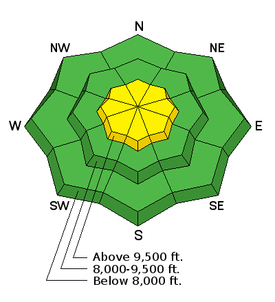
bottom line The AVALANCHE DANGER is MODERATE on any steep slope with drifts of wind-blown snow. While the drifts are most widespread in upper elevation terrain, there will be a few drifts on mid elevation slopes due to the strong winds. Out of the wind affected terrain, the avalanche danger is mostly LOW.
|
 |
special announcement Sale on all remaining discount lift tickets donated to the Utah Avalanche Center from Beaver Mountain, Wolf Mountain, Sundance, and Brian Head: The few remaining tickets are being blown out with all proceeds used to pay for avalanche advisories and education. Go here to get your tickets. Can you change Utah in a day? Utah's non-profit community is a big part of what makes living in Utah great. Join your community in a state-wide day of non-profit appreciation and support with Love Utah Give Utah on Thursday, March 20. Your donation to the Utah Avalanche Center between now and March 20 through this link, large or small, helps pay for avalanche advisories and education and makes the Utah Avalanche Center eligible for challenge grants and special awards provided by local businesses. In Salt Lake City? Stop by Squatters downtown on Th 3/20 between 4 and 6 for some free snacks, an opportunity to chat with some of the UAC folks, and make an online donation. |
 |
current conditions A cold front zipped through northern Utah last night, it was accompanied by strong northwesterly winds. Sustained speeds were the 50s, and gusts in the 60 to 80 mph range. So the 1 to 3 inches of dense snow it left in its wake has been blown all over, leaving a matrix of scoured, icy patches, soft snow on northerly facing slopes and scattered shallow drifts. Temperatures have dropped behind the front, and are in the teens along the high ridge lines, and in the 20s at the mid elevations. The west to northwesterly winds are still brisk this morning – 15 to 25 mph averages, gusting into the 40s, with a few of the highest stations still averaging 40 mph, gusting to 70. |
 |
recent activity The backcountry was mostly quiet yesterday, though one decent size wet loose sluff was reported from the Provo area mountains in Bear Claw. This is an easterly facing slope at 7,000’. In addition, a few new snow soft slabs were triggered with explosives in the Ogden area mountains. However, it’s always good to do a quick review of the past week’s avalanche activity. Complete avalanche list HERE. |
| type | aspect/elevation | characteristics |
|---|

|
|
LIKELIHOOD
 LIKELY
UNLIKELY
SIZE
 LARGE
SMALL
TREND
 INCREASING DANGER
SAME
DECREASING DANGER
|
|
description
Today’s greatest concern will be the shallow, new wind drifts. These will be most sensitive where they are sitting on the soft, slightly recrystallized old snow on the northerly and easterly facing slopes. While these drifts will be shallow, triggering even a small one in very steep or radical terrain could send you for a long ride or off a cliff. If you see a scoured area, be thinking “where did that snow go?” – work hard to identify and avoid any wind drifts on steep slopes. Again, and excellent observation of a skier triggered slide on Monte Cristo from last Wednesday. DETAILS . |
| type | aspect/elevation | characteristics |
|---|

|

|
LIKELIHOOD
 LIKELY
UNLIKELY
SIZE
 LARGE
SMALL
TREND
 INCREASING DANGER
SAME
DECREASING DANGER
|
|
description
Out of the wind affected terrain, there is a mostly LOW danger, though avalanches can still be triggered in isolated places -
|
 |
weather High pressure is building in for the weekend. Skies will rapidly clear this morning, and temperatures warm into the low 30s at 8,000’ and the low 20s at 10,000’. The pesky northwesterly winds will be slow to decrease, with high ridgeline stations still averaging about 30 mph, gusting to 50 mph, until about noon. Sunday will be another warm, sunny day, followed by another fast moving storm late Monday that should be good for another few inches of snow. |
| general announcements Remember your information can save lives. If you see anything we should know about, please participate in the creation of our own community avalanche advisory by submitting snow and avalanche conditions. You can also call us at 801-524-5304 or 800-662-4140, email by clicking HERE, or include #utavy in your tweet or Instagram. If you trigger an avalanche in the backcountry - especially if you are adjacent to a ski area – please call the following teams to alert them to the slide and whether anyone is missing or not. Rescue teams can be exposed to significant hazard when responding to avalanches, and do not want to do so when unneeded. Thanks. Salt Lake and Park City – Alta Central (801-742-2033), Canyons Resort Dispatch (435-615-3322) Snowbasin Resort Dispatch (801-620-1017), Powder Mountain Dispatch (801-745-3772 x 123). Sundance Dispatch (801-223-4150) EMAIL ADVISORY We have switched to a new SLC email advisory system. If you would like to get the daily advisory by email, or if you have been getting the advisory by email since the beginning of the season and wish to continue, you will need to subscribe here. DAWN PATROL Hotline updated daily by 5-530am - 888-999-4019 option 8. Twitter Updates for your mobile phone - DETAILS UDOT canyon closures: LINK TO UDOT Utah Avalanche Center mobile app - Get your advisory on your iPhone along with great navigation and rescue tools.uned. Wasatch Powderbird Guides Blog/Itinerary for the Day. Lost or Found something in the backcountry? - http://nolofo.com/ Discount lift tickets are now available at Backcountry.com - Thanks to Ski Utah and the Utah Resorts. All proceeds go towards paying for Utah Avalanche Center avalanche and mountain weather advisories. To those skinning uphill at resorts: it is your responsibility to know the resort policy on uphill travel. Some allow uphill travel and have guidelines, some don't. Contact the Ski Patrol at each resort for details. IMPORTANT: Before skinning at a resort under new snow conditions, check in with Ski Patrol. Resorts can restrict or cut off access if incompatible with control and grooming operations. Benefit the Utah Avalanche Center when you shop from Backcountry.com or REI: Click this link for Backcountry.com or this link to REI, shop, and they will donate a percent of your purchase price to the UAC. Both offer free shipping (with some conditions) so this costs you nothing! Benefit the Utah Avalanche Center when you buy or sell on ebay - set the Utah Avalanche Center as a favorite non-profit in your ebay account here and click on ebay gives when you buy or sell. You can choose to have your seller fees donated to the UAC, which doesn't cost you a penny. This information does not apply to developed ski areas or highways where avalanche control is normally done. This advisory is from the U.S.D.A. Forest Service, which is solely responsible for its content. This advisory describes general avalanche conditions and local variations always exist. |


_3.jpg)