| During the month of April, Mark Miller will donate $75 to the charity of your choice (5 to chose from, including the Utah Avalanche Center!) Mark Miller Subaru has raised over $300k in the previous 6 Do Good Feel Good events. More Info here |  |
| During the month of April, Mark Miller will donate $75 to the charity of your choice (5 to chose from, including the Utah Avalanche Center!) Mark Miller Subaru has raised over $300k in the previous 6 Do Good Feel Good events. More Info here | |
| Advisory: Provo Area Mountains | Issued by Bruce Tremper for Thursday - March 13, 2014 - 6:58am |
|---|

|
bottom line There is an overall MODERATE avalanche danger for lingering wind slabs in upper elevation, wind exposed terrain and also for damp or wet sluffs in steep terrain with day time heating by the sun. Be suspicious of steep slopes with recent wind drifts, which usually look smooth and rounded, and also steep slopes that are getting soggy in the heat of the day.
|
 |
current conditions Most of the snow from the storm a couple days ago fell in the upper Cottonwood Canyons (7-14 inches) with about half as much elsewhere. It was mostly dense graupel, that Styrofoam ball type of snow. Yesterday, the sun put a thin crust on most slopes and there's still dry, soft, creamy, snow on the northerly aspects. The stronger wind from the northeast a couple nights ago did some wind damage along the upper elevation, wind exposed terrain. Most popular slopes got tracked up yesterday.
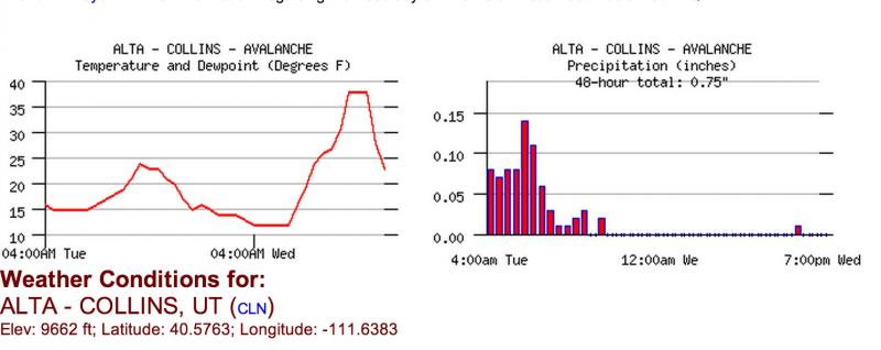
Here is a 2-day graph from Alta with the present time on the right of each graph. You can always view these yourself from the Snow Page.
|
 |
recent activity Yesterday morning quite a few people triggered shallow, soft slabs and sluffs in the steeper terrain. The strong, gusty, northeast winds from a couple nights ago created localized wind slabs in upper elevation wind exposed terrain. Perhaps the most serious one was in a steep, wind-loaded chute in Mineral Fork called No Mongo, which broke out 2-4 feet deep and 40 feet wide when a couple backcountry skiers crossed it. They self arrested on the bed surface. Several more shallow, soft slabs and sluffs occurred on the south face of Superior yesterday morning when perhaps 40 different people swarmed the face before the sun made it wet. A larger natural slab occurred in upper Hogum Fork during--or just after--the storm, which looks suspiciously like graupel pooling beneath the steep cliffs. Finally, yet another small glide avalanche occurred off the steep rock slabs in Broad's Fork, which is notorious for continually producing glide avalanches this time of year.
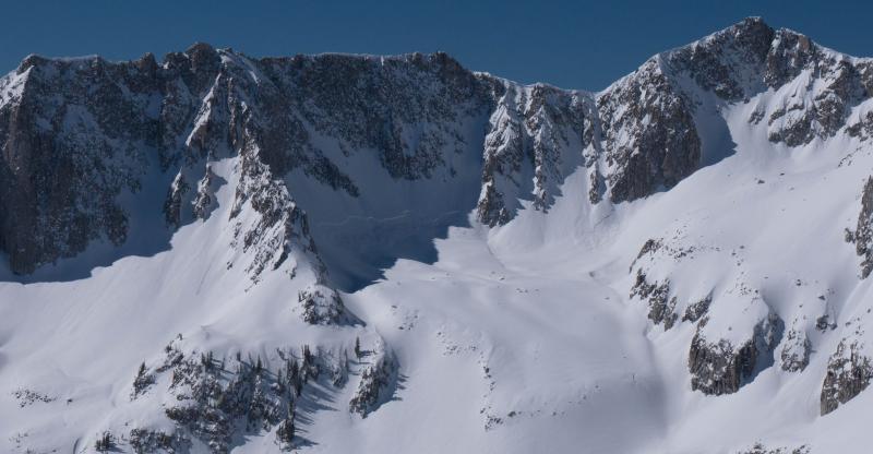
A deeper, connected slab in upper Hogum Fork (in the shadows under the cliff), which is probably pooling of the graupel beneath the steep cliffs.
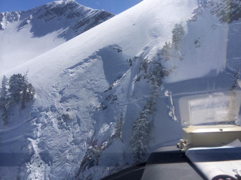
A steep, wind-loaded chute triggered by backcountry skiers in Mineral Fork. They self-arrested on the bed surface. Notice the smooth, rounded appearance of wind-deposited snow above the crown. Photo courtesy of Wasatch Powderbird Guides.
|
| type | aspect/elevation | characteristics |
|---|

|
|
LIKELIHOOD
 LIKELY
UNLIKELY
SIZE
 LARGE
SMALL
TREND
 INCREASING DANGER
SAME
DECREASING DANGER
|
|
description
You may still be able to find a few, lingering wind slabs in the upper elevation, wind exposed terrain. Since they were sliding on a graupel layer, it takes a little more time to stabilize than new snow avalanches. As usual, be suspicious of steep slopes with recent wind drifts, which often look smooth and rounded.
|
| type | aspect/elevation | characteristics |
|---|

|

|
LIKELIHOOD
 LIKELY
UNLIKELY
SIZE
LARGE
SMALL
TREND
INCREASING DANGER
SAME
DECREASING DANGER
|
|
description
Most of the sun exposed terrain turned damp or wet yesterday, at least on the snow surface. But temperatures were cool enough to keep wet activity to mostly just rollerballs. Today's temperatures should be about the same so I would expect similar activity but since the snow has already been there and don that, I'm not expecting too many problems. Still, sunny days in spring are never good times to get caught in steep, sun-baked terrain in the heat of the mid day or afternoon, especially in high consequence terrain. Timing is everything.
|
 |
weather Today should be similar to to yesterday with sunny skies, light wind, temperatures remaining pleasant but cool--just below freezing on the ridge tops and the mid to upper 30's at 8,000'. Friday should be similar but slightly warmer. Here's a cool wind graphic of mountain top level wind. For the extended forecast, we have a weak cold front mostly passing to the north of us on Saturday, which will give us perhaps a couple inches of snow with higher wind. Then temperatures should rebound for Sunday. We may get another snow storm about a week from now. |
| general announcements
Remember your information can save lives. If you see anything we should know about, please participate in the creation of our own community avalanche advisory by submitting snow and avalanche conditions. You can also call us at 801-524-5304 or 800-662-4140, email by clicking HERE, or include #utavy in your tweet or Instagram. If you trigger an avalanche in the backcountry - especially if you are adjacent to a ski area – please call the following teams to alert them to the slide and whether anyone is missing or not. Rescue teams can be exposed to significant hazard when responding to avalanches, and do not want to do so when unneeded. Thanks. Salt Lake and Park City – Alta Central (801-742-2033), Canyons Resort Dispatch (435-615-3322) Snowbasin Resort Dispatch (801-620-1017), Powder Mountain Dispatch (801-745-3772 x 123). Sundance Dispatch (801-223-4150) EMAIL ADVISORY We have switched to a new SLC email advisory system. If you would like to get the daily advisory by email, or if you have been getting the advisory by email since the beginning of the season and wish to continue, you will need to subscribe here. DAWN PATROL Hotline updated daily by 5-530am - 888-999-4019 option 8. Twitter Updates for your mobile phone - DETAILS UDOT canyon closures: LINK TO UDOT Utah Avalanche Center mobile app - Get your advisory on your iPhone along with great navigation and rescue tools.uned. Wasatch Powderbird Guides Blog/Itinerary for the Day. Lost or Found something in the backcountry? - http://nolofo.com/ Discount lift tickets are now available at Backcountry.com - Thanks to Ski Utah and the Utah Resorts. All proceeds go towards paying for Utah Avalanche Center avalanche and mountain weather advisories. To those skinning uphill at resorts: it is your responsibility to know the resort policy on uphill travel. Some allow uphill travel and have guidelines, some don't. Contact the Ski Patrol at each resort for details. IMPORTANT: Before skinning at a resort under new snow conditions, check in with Ski Patrol. Resorts can restrict or cut off access if incompatible with control and grooming operations. Benefit the Utah Avalanche Center when you shop from Backcountry.com or REI: Click this link for Backcountry.com or this link to REI, shop, and they will donate a percent of your purchase price to the UAC. Both offer free shipping (with some conditions) so this costs you nothing! Benefit the Utah Avalanche Center when you buy or sell on ebay - set the Utah Avalanche Center as a favorite non-profit in your ebay account here and click on ebay gives when you buy or sell. You can choose to have your seller fees donated to the UAC, which doesn't cost you a penny. This information does not apply to developed ski areas or highways where avalanche control is normally done. This advisory is from the U.S.D.A. Forest Service, which is solely responsible for its content. This advisory describes general avalanche conditions and local variations always exist. |


_3.jpg)