| During the month of April, Mark Miller will donate $75 to the charity of your choice (5 to chose from, including the Utah Avalanche Center!) Mark Miller Subaru has raised over $300k in the previous 6 Do Good Feel Good events. More Info here |  |
| During the month of April, Mark Miller will donate $75 to the charity of your choice (5 to chose from, including the Utah Avalanche Center!) Mark Miller Subaru has raised over $300k in the previous 6 Do Good Feel Good events. More Info here | |
| Advisory: Provo Area Mountains | Issued by Drew Hardesty for Wednesday - February 26, 2014 - 6:55am |
|---|

|
bottom line
|
 |
current conditions Skies are clear, temps are in the upper 20s and low 30s; winds are generally less than about 15mph from the west and northwest. Along the highest ridgelines, winds spin at 15-20mph. Most snow surfaces will be crusted this morning but should soften with daytime heating and sun. Upper elevation northerlies hold the last vestiges of thick, carveable powder. Enjoy spring while it lasts - storms moving in like a freight train are on tap - |
 |
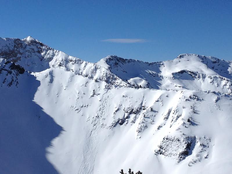
recent activity Natural cornice fall pulled out a decent hard slab 2-3' deep and 50' wide in upper Mineral Fork of Big Cottonwood Canyon yesterday morning. Located in what we affectionately call the Room of Doom, the avalanche ripped out in classic very steep, thin, rocky terrain in east-northeast facing terrain at 10,400'. (photo below WPG guide Logan Cookler)
|
| type | aspect/elevation | characteristics |
|---|

|

|
LIKELIHOOD
 LIKELY
UNLIKELY
SIZE
 LARGE
SMALL
TREND
 INCREASING DANGER
SAME
DECREASING DANGER
|
|
description
Should be another brilliant day in the mountains - easy travel, decent snow, fair weather, partly cloudy skies. It's conditions like these when people start getting in to more radical terrain where the margin for error is razor-thin. Remember that even shallow wind pockets or loose snow avalanches can be traumatic if they knock you off your feet in dramatic, steep, sustained terrain that we enjoy here in the Wasatch. Here are bullet points to keep in mind for today:
|
 |
weather This short-wave ridge of high pressure will give way to a series of increasingly strong Pacific storms through the weekend. For today, we'll have partly cloudy skies with generally light westerly winds and temps reaching the mid-30s at 10,000' and the low to mid-40s at 8000'. Look for increasing clouds in the afternoon. The first storm arrives tomorrow mid-day that should give us a quick shot of snow in the 3-7" range. This storm quickly moves on ahead of a more powerful storm off the Pacific coast that moves inland, drenching the intermountain west on a southwesterly storm track, affecting Utah Friday night through the weekend. 12-18" can be expected in an event that starts of warm and windy. Should be a good event for central Utah and areas favored by a southwest flow such as the Provo and Park City mountains.
|
| general announcements
Remember your information can save lives. If you see anything we should know about, please participate in the creation of our own community avalanche advisory by submitting snow and avalanche conditions. You can also call us at 801-524-5304 or 800-662-4140, email by clicking HERE, or include #utavy in your tweet or Instagram. If you trigger an avalanche in the backcountry - especially if you are adjacent to a ski area – please call the following teams to alert them to the slide and whether anyone is missing or not. Rescue teams can be exposed to significant hazard when responding to avalanches, and do not want to do so when unneeded. Thanks. Salt Lake and Park City – Alta Central (801-742-2033), Canyons Resort Dispatch (435-615-3322) Snowbasin Resort Dispatch (801-620-1017), Powder Mountain Dispatch (801-745-3772 x 123). Sundance Dispatch (801-223-4150) EMAIL ADVISORY We have switched to a new SLC email advisory system. If you would like to get the daily advisory by email, or if you have been getting the advisory by email since the beginning of the season and wish to continue, you will need to subscribe here. DAWN PATROL Hotline updated daily by 5-530am - 888-999-4019 option 8. Twitter Updates for your mobile phone - DETAILS UDOT canyon closures: LINK TO UDOT Utah Avalanche Center mobile app - Get your advisory on your iPhone along with great navigation and rescue tools.uned. Wasatch Powderbird Guides Blog/Itinerary for the Day. Lost or Found something in the backcountry? - http://nolofo.com/ Discount lift tickets are now available at Backcountry.com - Thanks to Ski Utah and the Utah Resorts. All proceeds go towards paying for Utah Avalanche Center avalanche and mountain weather advisories. To those skinning uphill at resorts: it is your responsibility to know the resort policy on uphill travel. Some allow uphill travel and have guidelines, some don't. Contact the Ski Patrol at each resort for details. IMPORTANT: Before skinning at a resort under new snow conditions, check in with Ski Patrol. Resorts can restrict or cut off access if incompatible with control and grooming operations. Benefit the Utah Avalanche Center when you shop from Backcountry.com or REI: Click this link for Backcountry.com or this link to REI, shop, and they will donate a percent of your purchase price to the UAC. Both offer free shipping (with some conditions) so this costs you nothing! Benefit the Utah Avalanche Center when you buy or sell on ebay - set the Utah Avalanche Center as a favorite non-profit in your ebay account here and click on ebay gives when you buy or sell. You can choose to have your seller fees donated to the UAC, which doesn't cost you a penny. This information does not apply to developed ski areas or highways where avalanche control is normally done. This advisory is from the U.S.D.A. Forest Service, which is solely responsible for its content. This advisory describes general avalanche conditions and local variations always exist. |


 The most widespread concern will be wet loose avalanching with sun and daytime warming on the steep east to south to west facing slopes of all elevations...and the low to mid-elevation northerly-facing terrain. Isolated areas exist where deeper slabs may release, but these are generally confined to steep upper elevation northerly slopes in thin rocky terrain.
_3.jpg)