| During the month of April, Mark Miller will donate $75 to the charity of your choice (5 to chose from, including the Utah Avalanche Center!) Mark Miller Subaru has raised over $300k in the previous 6 Do Good Feel Good events. More Info here |  |
| During the month of April, Mark Miller will donate $75 to the charity of your choice (5 to chose from, including the Utah Avalanche Center!) Mark Miller Subaru has raised over $300k in the previous 6 Do Good Feel Good events. More Info here | |
| Advisory: Provo Area Mountains | Issued by Drew Hardesty for Thursday - January 2, 2014 - 7:01am |
|---|


|
bottom line A MODERATE danger exists on mid and upper elevation, west through north through easterly facing slopes. Large avalanches are possible in isolated areas. Low probability, high consequence. What's your level of acceptable risk? Also don't overlook the recent wind-drifting - continue to avoid the smooth, rounded recent deposits of wind drifted snow (on primarily north through east through southeast facing slopes).
|
 |
special announcement Snowbasin Freeride Workshop - The Utah Avalanche Center, Snowbasin, Salomon, Atomic, and Suunto are pleased to announce the 2014 Snowbasin Freeride Workshop for competitive athletes, filmmakers, those with competitive or film production aspirations, and those who want to be more confident in exposed backcountry lines. January 26 evening session, January 27 & 28 field days. Click here for more info -
The Utah Avalanche Center along with the Montana State University Ski Tracks project combines GPS technology with detailed logbook surveys completed by participants to help us understand how and why decisions are made in the winter backcountry. Participants will use a free smartphone app to record and send us their ski routes then, they will complete a simple online survey telling us some of the features of their tour. For more information visit: www.montana.edu/snowscience/tracks |
 |
current conditions Skies are clear, temps are in the mid to upper 20s and the west to northwesterly winds are generally 15mph or less. Ridgetop winds are 18-22mph. Riding conditions are a mixed bag of wind and sun crusts with a patch or two of soft settled powder thrown in the mix. Still, when asked about the skiing and riding conditions, the reply is the same - "Always good." Snowshoeing and snowmobiling conditions are challenging with unsupportable cohesionless snow and thinly buried obstacles in many mid and low elevation areas...best to stick to packed out trails and groomed/packed roads.
|
 |
recent activity No avalanches were reported from the backcountry yesterday. |
| type | aspect/elevation | characteristics |
|---|

|

|
LIKELIHOOD
 LIKELY
UNLIKELY
SIZE
 LARGE
SMALL
TREND
 INCREASING DANGER
SAME
DECREASING DANGER
|
|
description
There's an isolated possibility of triggering one of these mostly dormant persistent slabs up to 3' deep. Our last significant activity with this layering was in lockstep with our last storms on the 19-23rd...with, as one would expect, a few pockets triggered here and there through Christmas. Collapsing, however, continues to be noted with irregularity and snow "stability' tests continue to produce conflicting messages. This leads, of course, to some uncertainty, and uncertainty should lead to caution. It should also lead to strict travel protocols and communication, and "setting yourself up for success", also known as "setting yourself up to avoid disaster". In other words, pause...just for a moment before jumping in and ask yourself two questions -
With either, consider whether you're alone, with competent or incompetent partners. Will the avalanche drag me into a stand of trees and snap my femur, bury me deeply in a steep walled gully or terrain trap....Will it push me over a cliff band?.......Or will it be a smaller, more open slope where the debris fans out evenly? This is what I mean by stacking the odds in your favor - if you're wrong with the snow, don't be wrong with the terrain...
|
| type | aspect/elevation | characteristics |
|---|

|

|
LIKELIHOOD
LIKELY
UNLIKELY
SIZE
 LARGE
SMALL
TREND
 INCREASING DANGER
SAME
DECREASING DANGER
|
|
description
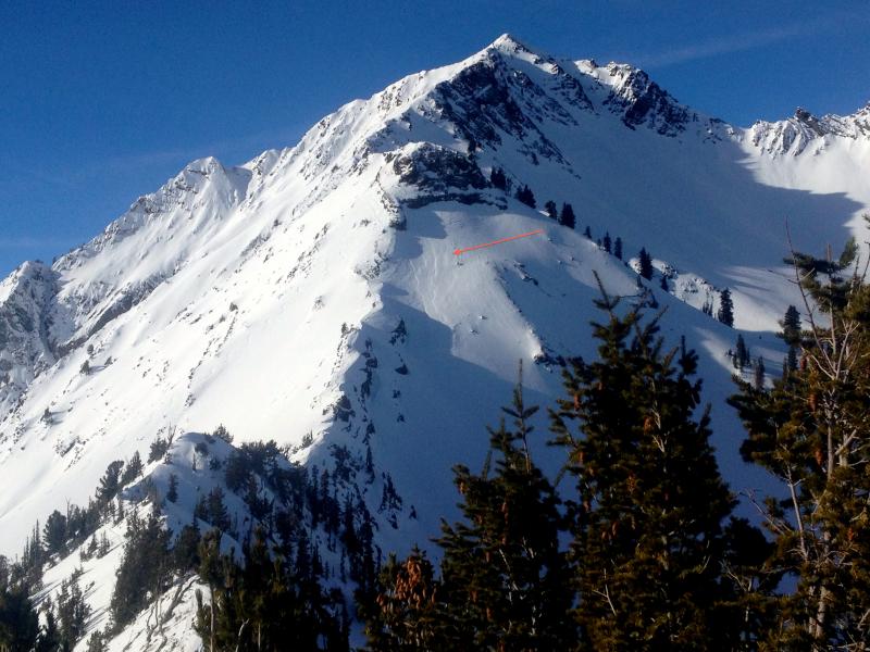
New wind slabs dotted the landscape yesterday up to a foot deep and noted in both typical and atypical terrain. Northwest winds from Tuesday/Tuesday night led to some scalloping and drifting in lee terrain in primarily the upper elevations. They look smooth and rounded and typically adjust within a couple of days. See pic below of northwesterly wind cross-loading -
|
 |
weather We'll have clear skies, generally light northwesterly wind (<15mph) and temps reaching toward freezing at 10,000', near 40 at 8000'. A weak storm from the northwest moves in for tomorrow afternoon through midday Saturday that is likely to produce 1-3" and significant wind. Northwesterly winds should ramp up Friday afternoon through early Saturday with ridgetop speeds averaging 35-40mph for 18 hours or so. Temps also drop to about 10 degrees by later Saturday. Skies clear by Sunday with perhaps a series of disturbances (I hesitate to call them storms right now) starting Tuesday... |
| general announcements
This information does not apply to developed ski areas or highways where avalanche control is normally done. This advisory is from the U.S.D.A. Forest Service, which is solely responsible for its content. This advisory describes general avalanche conditions and local variations always occur. If you trigger an avalanche in the backcountry - especially if you are adjacent to a ski area – please call the following teams to alert them to the slide and whether anyone is missing or not. Rescue teams can be exposed to significant hazard when responding to avalanches, and do not want to do so when unneeded. Thanks. Salt Lake and Park City – Alta Central (801-742-2033), Canyons Resort Dispatch (435-615-3322) Snowbasin Resort Dispatch (801-620-1017), Powder Mountain Dispatch (801-745-3772 x 123). Sundance Dispatch (801-231-4150) EMAIL ADVISORY Get the Salt Lake avalanche advisory emailed to you every morning. CLICK HERE FOR DETAILS DAWN PATROL Hotline updated daily by 5-530am - 888-999-4019 option 8. Twitter Updates for your mobile phone - DETAILS UDOT canyon closures: LINK TO UDOT Utah Avalanche Center mobile app - Get your advisory on your iPhone along with great navigation and rescue tools.uned. Wasatch Powderbird Guides Blog/Itinerary for the Day. They'll be up and running later this winter - Lost or Found something in the backcountry? - http://nolofo.com/ Discount lift tickets are now available at Backcountry.com - Thanks to Ski Utah and the Utah Resorts. All proceeds go towards paying for Utah Avalanche Center avalanche and mountain weather advisories. To those skinning uphill at resorts: it is your responsibility to know the resort policy on uphill travel. Some allow uphill travel and have guidelines, some don't. Contact the Ski Patrol at each resort for details. IMPORTANT: Before skinning at a resort under new snow conditions, check in with Ski Patrol. Resorts can restrict or cut off access if incompatible with control and grooming operations. Benefit the Utah Avalanche Center when you shop from Backcountry.com or REI: Click this link for Backcountry.com or this link to REI, shop, and they will donate a percent of your purchase price to the UAC. Both offer free shipping (with some conditions) so this costs you nothing! Benefit the Utah Avalanche Center when you buy or sell on ebay - set the Utah Avalanche Center as a favorite non-profit in your ebay account here and click on ebay gives when you buy or sell. You can choose to have your seller fees donated to the UAC, which doesn't cost you a penny. Remember your information can save lives. If you see anything we should know about, please participate in the creation of our own community avalanche advisory by submitting snow and avalanche conditions. You can also call us at 801-524-5304 or 800-662-4140, email by clicking HERE, or include #utavy in your tweet or Instagram. Ski Utah mobile snow updates: |


_3.jpg)