
| During the month of April, Mark Miller will donate $75 to the charity of your choice (5 to chose from, including the Utah Avalanche Center!) Mark Miller Subaru has raised over $300k in the previous 6 Do Good Feel Good events. More Info here |  |
| During the month of April, Mark Miller will donate $75 to the charity of your choice (5 to chose from, including the Utah Avalanche Center!) Mark Miller Subaru has raised over $300k in the previous 6 Do Good Feel Good events. More Info here | |
| Advisory: Provo Area Mountains | Issued by Brett Kobernik for Wednesday - December 25, 2013 - 7:27am |
|---|

|
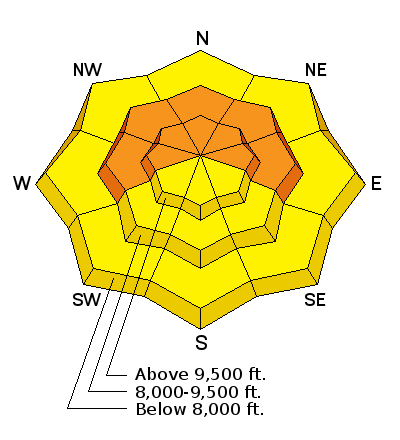
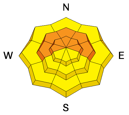
bottom line A CONSIDERABLE avalanche danger remains in place today for steep slopes that face west through north through east above 8500 feet. HUMAN TRIGGERED AVALANCHES ARE LIKELY. Make no mistake, this is accident weather - beautiful days with new snow, pre-existing buried weak snow and lots of people headed into the mountains during the holidays.
|
 |
special avalanche bulletin HUMAN TRIGGERED AVALANCHES LIKELY IN MANY AREAS OF NORTHERN UTAH. The combination of recent snow resting on pre-existing weak layers has created unstable avalanche conditions. Beautiful weather and lot's of people heading into the mountains during the holidays during these dangerous avalanche conditions is just the recipe for an accident. Keep off of and out from underneath steep slopes that face west through north through east. |
 |
current conditions X mas avalanche advisory carol - Ding Avalanche! from Brett Kobernik on Vimeo. |
 |
recent activity There is a distinct slab present now in many regions of the northern Utah mountains. There was one snowmobile triggered avalanche in Dry Fork on Tuesday which averaged 3 feet deep and was around 300 feet wide on an east facing slope at 10400 feet in elevation. Albion & Dry Fork from Brett Kobernik on Vimeo. Very similar conditions are present in the Western Uintas where Craig and Trent were able to get this small slope to release. |
| type | aspect/elevation | characteristics |
|---|

|
|
LIKELIHOOD
 LIKELY
UNLIKELY
SIZE
 LARGE
SMALL
TREND
 INCREASING DANGER
SAME
DECREASING DANGER
|
|
description
Yeah, it's the real deal out there now people. The last storm has produced a nice slab that is resting on weak sugary faceted snow. The facets just need a little thump to produce an avalanche as demonstrated in the videos above. Avalanches can be triggered from below the avalanche path so you really need to watch what is above you. The winds are increasing right now along the ridges and any snow transport will exacerbate this avalanche problem. |
| type | aspect/elevation | characteristics |
|---|

|

|
LIKELIHOOD
 LIKELY
UNLIKELY
SIZE
 LARGE
SMALL
TREND
 INCREASING DANGER
SAME
DECREASING DANGER
|
|
description
The sun may heat southerly facing slopes enough to produce some instability. I seriously doubt this will pose much threat to people out there but it's worth a mention. |
 |
weather High pressure starts to build in today with a beautiful day in store. We will see some gusty conditions along the ridgetops but winds should taper off as the day goes on. We'll have sunny skies and ridgetop temperatures in the mid to upper 20s. Mild weather will continue into the weekend. Temperatures cool off as a dry trough moves through late Saturday. High pressure returns with no storms visible in the 10 day outlook. |
| general announcements This information does not apply to developed ski areas or highways where avalanche control is normally done. This advisory is from the U.S.D.A. Forest Service, which is solely responsible for its content. This advisory describes general avalanche conditions and local variations always occur. If you trigger an avalanche in the backcountry - especially if you are adjacent to a ski area – please call the following teams to alert them to the slide and whether anyone is missing or not. Rescue teams can be exposed to significant hazard when responding to avalanches, and do not want to do so when unneeded. Thanks. Salt Lake and Park City – Alta Central (801-742-2033), Canyons Resort Dispatch (435-615-3322) Snowbasin Resort Dispatch (801-620-1017), Powder Mountain Dispatch (801-745-3772 x 123). Sundance Dispatch (801-231-4150) DAWN PATROL Hotline updated daily by 5-530am - 888-999-4019 option 8. Twitter Updates for your mobile phone - DETAILS UDOT canyon closures: LINK TO UDOT Utah Avalanche Center mobile app - Get your advisory on your iPhone along with great navigation and rescue tools. We'll soon be lining up a new automated emailed advisory delivery system - stay tuned. Wasatch Powderbird Guides Blog/Itinerary for the Day. They'll be up and running later this winter - Lost or Found something in the backcountry? - http://nolofo.com/ Discount lift tickets are now available at Backcountry.com - Thanks to Ski Utah and the Utah Resorts. All proceeds go towards paying for Utah Avalanche Center avalanche and mountain weather advisories. To those skinning uphill at resorts: it is your responsibility to know the resort policy on uphill travel. Some allow uphill travel and have guidelines, some don't. Contact the Ski Patrol at each resort for details. IMPORTANT: Before skinning at a resort under new snow conditions, check in with Ski Patrol. Resorts can restrict or cut off access if incompatible with control and grooming operations. Benefit the Utah Avalanche Center when you shop from Backcountry.com or REI: Click this link for Backcountry.com or this link to REI, shop, and they will donate a percent of your purchase price to the UAC. Both offer free shipping (with some conditions) so this costs you nothing! Benefit the Utah Avalanche Center when you buy or sell on ebay - set the Utah Avalanche Center as a favorite non-profit in your ebay account here and click on ebay gives when you buy or sell. You can choose to have your seller fees donated to the UAC, which doesn't cost you a penny. Remember your information can save lives. If you see anything we should know about, please participate in the creation of our own community avalanche advisory by submitting snow and avalanche conditions. You can also call us at 801-524-5304 or 800-662-4140, email by clicking HERE, or include #utavy in your tweet or Instagram. |


_3.jpg)