| During the month of April, Mark Miller will donate $75 to the charity of your choice (5 to chose from, including the Utah Avalanche Center!) Mark Miller Subaru has raised over $300k in the previous 6 Do Good Feel Good events. More Info here |  |
| During the month of April, Mark Miller will donate $75 to the charity of your choice (5 to chose from, including the Utah Avalanche Center!) Mark Miller Subaru has raised over $300k in the previous 6 Do Good Feel Good events. More Info here | |
| Advisory: Provo Area Mountains | Issued by Bruce Tremper for Monday - December 23, 2013 - 7:16am |
|---|


|
bottom line AVOID: backcountry travel today on any slope approaching 35 degrees and steeper including locally-connected terrain especially slopes facing generally the north half of the compass plus east facing slopes. Also avoid avalanche run out areas. USUALLY-SAFE: You can find excellent turning, riding and snow shoeing on gentler slopes, less steep than about 30 degrees, in wind sheltered terrain not locally-connected to steeper terrain. Avoid avalanche run out areas. Backcountry travelers need excellent route finding and decision making skills. If you want to ski or board steep terrain, go to one of the awesome Utah resorts.
|
 |
special avalanche bulletin THIS SPECIAL AVALANCHE BULLETIN IS FOR THE MOUNTAINS OF NORTHERN UTAH TO INCLUDE THE WESTERN UINTAS. A HIGH AVALANCHE DANGER EXISTS FOR MOST OF THE MOUNTAINS OF NORTHERN UTAH. VISIT WWW.UTAHAVALANCHECENTER FOR MORE DETAILS. THIS ADVISORY DOES NOT INCLUDE SKI AREAS OR HIGHWAYS WHERE AVALANCHE CONTROL IS NORMALLY DONE. |
 |
special announcement Little Cottonwood Canyon is closed this morning for avalanche control and is expected to reopen by 8:00 am. The Utah Avalanche Center wishes you a safe and powder-filled holiday season. Please consider the UAC in your holiday giving plans - your donations pay for these advisories and we can't do this without your help. What is it worth to you every day to get an avalanche and mountain weather advisory? The cost of a beverage or the gas it takes to get to the mountains? You can donate here. |
 |
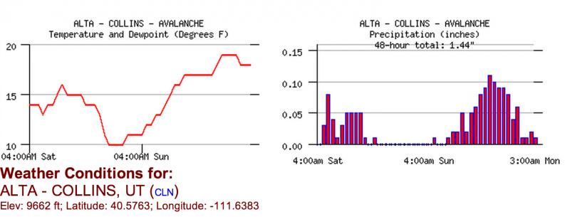
current conditions Lots of graupel fell over the past 24 hours (that Styrofoam ball type of snow) with 9 inches of snow containing an amazing 1.6 inches of water weight measured at two different weather stations at Alta. Densities have steadily risen starting around 5% yesterday to 20% overnight. The freezing level has risen to around 7,000' and the winds continue to blow moderate to hard from the northwest especially at high elevations. The most precipitation fell in the Cottonwood Canyons and the Logan area mountains.
Here is a 2-day graph of temperature and precipitation at the Collins weather station. |
 |
recent activity For a welcome change, we did not hear about any human triggered avalanches from the backcountry yesterday but a couple more reports dribbled in from human triggered avalnaches on Saturday including yet another serious incident in Hidden Canyon (an uncontrolled backcountry area near Brighton) with a long ride and injured knee and an unintentional human triggered avalanche in Silver Fork Meadow Chutes. Overnight, the infrasonic sensor network in Little Cottonwood Canyon recorded several natural avalanches on the steep south facing slopes but none hit the road. Avalanche reduction work with explosives in the Park City mountains once again produced large slides, especially in non-skier compacted terrain. One was 4 feet deep, 250 feet wide on an east-northeast facing slope at 9,800'. |
| type | aspect/elevation | characteristics |
|---|

|
|
LIKELIHOOD
 LIKELY
UNLIKELY
SIZE
 LARGE
SMALL
TREND
 INCREASING DANGER
SAME
DECREASING DANGER
|
|
description
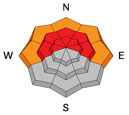
We have monsters in the basement on the shady aspects. A thick layer of weak, faceted snow is now buried a couple feet deep and people have triggered a couple dozen, large avalanches on this layer since Friday. We've had 3.5 inches of water weight plunked down on top of this very weak layer since Thursday and it just can't support the weight. Another wallop of weight in the last 24 hours (1.6" of water) should reactivate this layer and I wouldn't be surprised to see some large, natural avalanche activity today. Avalanche danger depends on BOTH probability and consequences. Human triggered avalanches are likely and the avalanches will not only be 2 or more feet deep, but in this shallow snowpack, even small avalanches will rake you through rocks and logs making the consequences much more serious than usual. Therefore, there is a HIGH avalanche danger on slopes generally facing the north half of the compass plus east facing slopes above about 8,000' on slopes approaching 35 degrees and steeper including locally-connected terrain. If you go to this terrain, keep your steepness under 30 degrees and out from underneath steeper slopes. |
| type | aspect/elevation | characteristics |
|---|

|
|
LIKELIHOOD
LIKELY
UNLIKELY
SIZE
 LARGE
SMALL
TREND
INCREASING DANGER
SAME
DECREASING DANGER
|
|
description
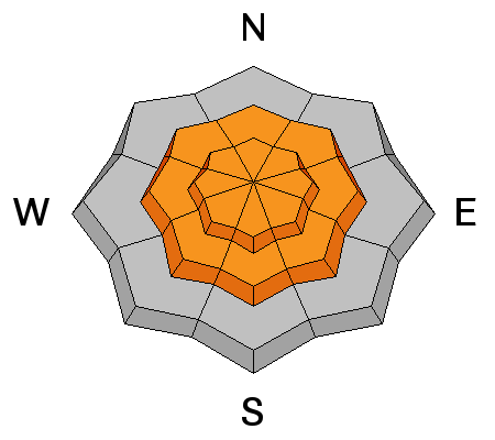
With rising temperature, snow density and wind, expect avalanches within the new snow on all the steeper terrain. The snow may be "upside down" and slabby as densities have risen from 5% yesterday to 20% overnight. |
| type | aspect/elevation | characteristics |
|---|

|
|
LIKELIHOOD
LIKELY
UNLIKELY
SIZE
LARGE
SMALL
TREND
 INCREASING DANGER
SAME
DECREASING DANGER
|
|
description
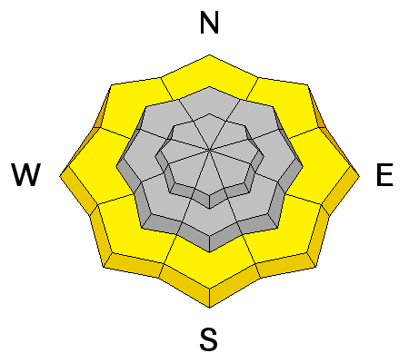
With a rising freezing level today, expect light rain and wet snow below about 7,000'. This may create both human triggered potential and natural sluffs in steep terrain. |
 |
weather Temperatures will continue to rise and get up into the upper 20's at 8,000' with the rain-snow line getting up around 7,000'. Light snow should continue to fall at upper elevations with light rain at lower elevations. Precipitation should end by about mid day. Ridge top winds will vary dramatically by elevation with moderate winds down low and 40 mph wind from the northwest on the higher peaks. We have a modest Christmas present with a weak cold front expected on Tuesday, which will bring some light snow and drop temperatures into the teens. After that, we don't see any significant precipitation for at least another week or more. |
| general announcements This information does not apply to developed ski areas or highways where avalanche control is normally done. This advisory is from the U.S.D.A. Forest Service, which is solely responsible for its content. This advisory describes general avalanche conditions and local variations always occur. If you trigger an avalanche in the backcountry - especially if you are adjacent to a ski area – please call the following teams to alert them to the slide and whether anyone is missing or not. Rescue teams can be exposed to significant hazard when responding to avalanches, and do not want to do so when unneeded. Thanks. Salt Lake and Park City – Alta Central (801-742-2033), Canyons Resort Dispatch (435-615-3322) Snowbasin Resort Dispatch (801-620-1017), Powder Mountain Dispatch (801-745-3772 x 123). Sundance Dispatch (801-231-4150) DAWN PATROL Hotline updated daily by 5-530am - 888-999-4019 option 8. Twitter Updates for your mobile phone - DETAILS UDOT canyon closures: LINK TO UDOT Utah Avalanche Center mobile app - Get your advisory on your iPhone along with great navigation and rescue tools. We'll soon be lining up a new automated emailed advisory delivery system - stay tuned. Wasatch Powderbird Guides Blog/Itinerary for the Day. They'll be up and running later this winter - Lost or Found something in the backcountry? - http://nolofo.com/ Discount lift tickets are now available at Backcountry.com - Thanks to Ski Utah and the Utah Resorts. All proceeds go towards paying for Utah Avalanche Center avalanche and mountain weather advisories. To those skinning uphill at resorts: it is your responsibility to know the resort policy on uphill travel. Some allow uphill travel and have guidelines, some don't. Contact the Ski Patrol at each resort for details. IMPORTANT: Before skinning at a resort under new snow conditions, check in with Ski Patrol. Resorts can restrict or cut off access if incompatible with control and grooming operations. Benefit the Utah Avalanche Center when you shop from Backcountry.com or REI: Click this link for Backcountry.com or this link to REI, shop, and they will donate a percent of your purchase price to the UAC. Both offer free shipping (with some conditions) so this costs you nothing! Benefit the Utah Avalanche Center when you buy or sell on ebay - set the Utah Avalanche Center as a favorite non-profit in your ebay account here and click on ebay gives when you buy or sell. You can choose to have your seller fees donated to the UAC, which doesn't cost you a penny. Remember your information can save lives. If you see anything we should know about, please participate in the creation of our own community avalanche advisory by submitting snow and avalanche conditions. You can also call us at 801-524-5304 or 800-662-4140, email by clicking HERE, or include #utavy in your tweet or Instagram. |


_3.jpg)