
| During the month of April, Mark Miller will donate $75 to the charity of your choice (5 to chose from, including the Utah Avalanche Center!) Mark Miller Subaru has raised over $300k in the previous 6 Do Good Feel Good events. More Info here |  |
| During the month of April, Mark Miller will donate $75 to the charity of your choice (5 to chose from, including the Utah Avalanche Center!) Mark Miller Subaru has raised over $300k in the previous 6 Do Good Feel Good events. More Info here | |
| Advisory: Provo Area Mountains | Issued by Brett Kobernik for Friday - December 6, 2013 - 7:16am |
|---|

|
bottom line Overall, the avalanche danger is MODERATE. This means that human triggered avalanches are possible and are most likely on slopes approaching 40 degrees in steepness above around 9000 feet that face northwest, north and northeast. Any snow transport that occurs during the day today will INCREASE THE AVALANCHE DANGER, especially along the ridges.
|
 |
special announcement Deer Valley is now closed to uphill travel as they prepare the mountain for lift served skiing. |
 |
current conditions BRRRRRR!!! Ridgetop temperatures remain very cold at 5 to 10 BELOW zero. Luckily, the winds are still light at this time. A trace of new snow fell during the day on Thursday. The most recent snow remains quite delightful albeit a bit slow under the boards due to the cold temperatures. A good cold snow wax can help combat this. |
| type | aspect/elevation | characteristics |
|---|

|

|
LIKELIHOOD
 LIKELY
UNLIKELY
SIZE
 LARGE
SMALL
TREND
 INCREASING DANGER
SAME
DECREASING DANGER
|
|
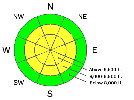
description
Weak faceted snow under the newest snow still poses the greatest danger to a person out there in my book. The chances for triggering a slab avalanche on the upper elevation northerly facing have decreased since the storm, but the consequences if you do trigger one are what makes this dangerous. If you do choose to get onto steep northerly facing terrain, you better be DANG WELL SURE you know EXACTLY what the previous snow was like prior to this storm. If you don't, it's a roll of the dice. Southwest winds may increase enough as the day goes on to transport snow which will enhance this avalanche problem. |
| type | aspect/elevation | characteristics |
|---|

|
|
LIKELIHOOD
 LIKELY
UNLIKELY
SIZE
 LARGE
SMALL
TREND
INCREASING DANGER
SAME
DECREASING DANGER
|
|
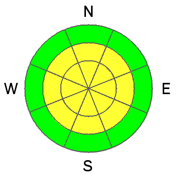
description
The instability that was within the newest layers of snow is still sensitive. Usually, these new snow instabilities "settle out" or stabilize fairly quickly. I suspect the very cold temperatures are contributing to this lingering weakness. This weakness is what I'd call "manageable" especially for those with a good amount of experience in avalanche terrain. With this type of avalanche problem, ski cuts are very effective in revealing if a steep slope is going to release. Burial is not all that likely with this problem. Going for a ride in an avalanche could cause injury though. Keep in mind that a bump in wind speeds along with snow transport will enhance this avalanche problem. |
 |
weather Temperatures are going to get a little warmer today as the flow shifts more southwest. Many locations still won't get out of the single digits though. As we've had the last few days, cloud cover and light snow showers are once again possible. Southwest winds will start to increase as the day goes on, perhaps enough to start transporting the loose snow on the surface. A storm system will start to impact our area on Saturday and it's looking a little better now for snow accumulation than it did a few days back. We should see snow start during the day in warm air advection with a few inches possible and more coming Saturday night. A 1/2 inch to an inch of water is anticipated in the new snow which translates to, hopefully, around a foot of snow. |
| general announcements
This information does not apply to developed ski areas or highways where avalanche control is normally done. This advisory is from the U.S.D.A. Forest Service, which is solely responsible for its content. This advisory describes general avalanche conditions and local variations always occur. If you trigger an avalanche in the backcountry - especially if you are adjacent to a ski area – please call the following teams to alert them to the slide and whether anyone is missing or not. Rescue teams can be exposed to significant hazard when responding to avalanches, and do not want to do so when unneeded. Thanks. Salt Lake and Park City – Alta Central (801-742-2033), Canyons Resort Dispatch (435-615-3322) Twitter Updates for your mobile phone - DETAILS UDOT canyon closures: LINK TO UDOT Utah Avalanche Center mobile app - Get your advisory on your iPhone along with great navigation and rescue tools. We'll soon be lining up a new automated emailed advisory delivery system - stay tuned. Wasatch Powderbird Guides Blog/Itinerary for the Day. They'll be up and running later this winter - Discount lift tickets are now available at Backcountry.com - Thanks to Ski Utah and the Utah Resorts. All proceeds go towards paying for Utah Avalanche Center avalanche and mountain weather advisories. To those skinning uphill at resorts: it is your responsibility to know the resort policy on uphill travel. Some allow uphill travel and have guidelines, some don't. Contact the Ski Patrol at each resort for details. IMPORTANT: Before skinning at a resort under new snow conditions, check in with Ski Patrol. Resorts can restrict or cut off access if incompatible with control and grooming operations. Benefit the Utah Avalanche Center when you shop from Backcountry.com or REI: Click this link for Backcountry.com or this link to REI, shop, and they will donate a percent of your purchase price to the UAC. Both offer free shipping (with some conditions) so this costs you nothing! Benefit the Utah Avalanche Center when you buy or sell on ebay - set the Utah Avalanche Center as a favorite non-profit in your ebay account here and click on ebay gives when you buy or sell. You can choose to have your seller fees donated to the UAC, which doesn't cost you a penny. Remember your information can save lives. If you see anything we should know about, please participate in the creation of our own community avalanche advisory by submitting snow and avalanche conditions. You can also call us at 801-524-5304 or 800-662-4140, email by clicking HERE, or include #utavy in your tweet or Instagram. |


_3.jpg)
