| During the month of April, Mark Miller will donate $75 to the charity of your choice (5 to chose from, including the Utah Avalanche Center!) Mark Miller Subaru has raised over $300k in the previous 6 Do Good Feel Good events. More Info here |  |
| During the month of April, Mark Miller will donate $75 to the charity of your choice (5 to chose from, including the Utah Avalanche Center!) Mark Miller Subaru has raised over $300k in the previous 6 Do Good Feel Good events. More Info here | |
| Advisory: Provo Area Mountains | Issued by Bruce Tremper for Thursday - December 5, 2013 - 7:16am |
|---|

|
bottom line Overall, the avalanche danger is Level 2 (MODERATE). There are areas with a Level 3 (CONSIDERABLE) danger in the upper elevation northwest through northeast facing slopes approaching 35 degrees and steeper especially ones with recent wind deposits. Also, even small avalanches will beat you up on the many rocks and stumps you will hit on the way down.
|
 |
special announcement
|
 |
current conditions Yikes, it's cold enough this morning to remind me of my native state of Montana. Double digit, below-zero temperatures exist in most of the mountain weather stations from -10 to -20 F. Winds have calmed down. The red line below is temperature and the red bars are hourly snowfall in water equivalent. About a foot of low density snow from the past couple days sit on a wide variety of surfaces ranging from bare rocks on the south facing slopes to weak, faceted snow on the upper elevation north facing slopes. Total snowpack depths range from 1.5 - 3 feet. Yesterday's west wind created localized areas of wind drifting along the upper elevation ridges but otherwise, the new snow is still soft, but stiff and slow from the cold.
|
 |
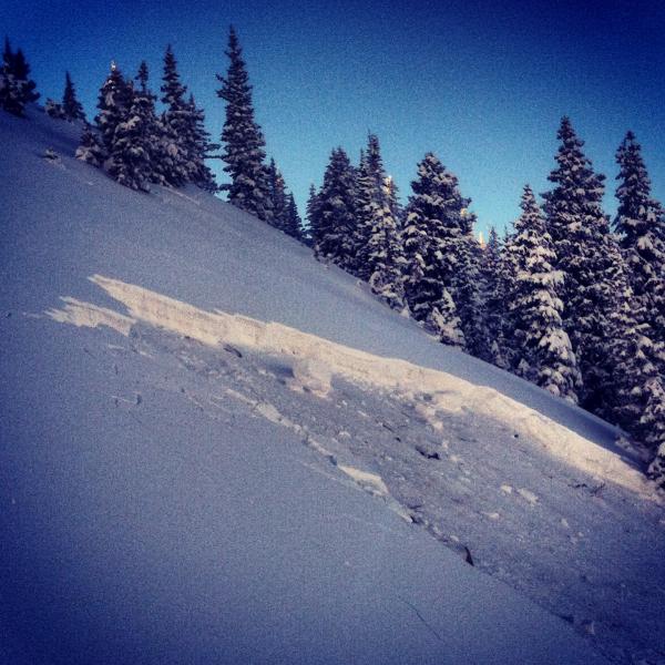
recent activity Yesterday, backcountry skiers triggered several avalanches, some were within the new snow as both soft slabs and wind slabs, but at least one broke down a couple feet deep to weak, faceted snow near the ground (see photo).
Remotely-triggered avalanche on northeast facing 10,420, which is at the head of Big Cottonwood Canyon |
| type | aspect/elevation | characteristics |
|---|

|
|
LIKELIHOOD
 LIKELY
UNLIKELY
SIZE
 LARGE
SMALL
TREND
 INCREASING DANGER
SAME
DECREASING DANGER
|
|
description
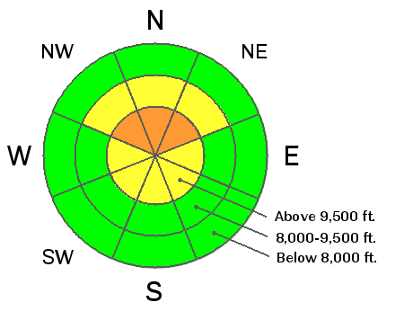
As usual in the early season, buried layers of persistent weak layers continue to produce avalanches each time new snow or wind blown snow adds weight on top of them. A thick layer of faceted snow and depth hoar exist under the new snow on most of the upper elevation north and east facing slopes. Although the new snow did not weigh enough to create widespread avalanches, it has made the snowpack cranky. You will most likely find pockets where monsters lurk in the basement on slopes with the combination of 1) relatively undisturbed, untracked snow before this past storm and 2) recent deposits of wind drifted snow (mostly on east facing slopes). In other words, the slopes on the east side of the range (Park City ridgeline) are worse than in the Cottonwood Canyons. The danger is mostly Moderate in the Wasatch Range but there's is just enough monkey business going on that I'm calling it Considerable especially since even smaller avalanches will beat you up by hitting many rocks and stumps on your descent. It's just not worth messing with them. |
| type | aspect/elevation | characteristics |
|---|

|
|
LIKELIHOOD
LIKELY
UNLIKELY
SIZE
 LARGE
SMALL
TREND
 INCREASING DANGER
SAME
DECREASING DANGER
|
|
description
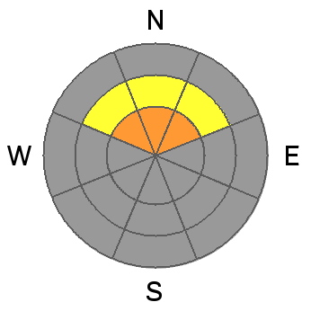
Wind from the west picked up yesterday during the day and created localized deposits of wind drifted snow along the upper elevation ridges. These wind slabs exist mostly on east facing slopes but exist on other slopes as well. As usual, avoid all steep slopes with recent wind deposits, which usually look smooth and rounded. |
 |
weather Down coat, mittens, extra-thick long underwear, face mask--you will need it all today. Temperatures will warm from the -10 to -20 this morning up to a balmy zero later in the morning with warming by the sun. But there is enough moisture in the air that, once again, the clouds will pop up around the mountains, which will cause fog and light snow through much of the day without much accumulation. Ridge top winds will blow 10-15 from the west. Friday should be windier, warmer and cloudier as the weekend storm approaches. It looks like we should get some fairly strong southwest winds on Saturday with another shot of snow Saturday night into Sunday, which may give us another 6 inches to as much as a foot of new snow. |
| general announcements
This information does not apply to developed ski areas or highways where avalanche control is normally done. This advisory is from the U.S.D.A. Forest Service, which is solely responsible for its content. This advisory describes general avalanche conditions and local variations always occur. If you trigger an avalanche in the backcountry - especially if you are adjacent to a ski area – please call the following teams to alert them to the slide and whether anyone is missing or not. Rescue teams can be exposed to significant hazard when responding to avalanches, and do not want to do so when unneeded. Thanks. Salt Lake and Park City – Alta Central (801-742-2033), Canyons Resort Dispatch (435-615-3322) Twitter Updates for your mobile phone - DETAILS UDOT canyon closures: LINK TO UDOT Utah Avalanche Center mobile app - Get your advisory on your iPhone along with great navigation and rescue tools. We'll soon be lining up a new automated emailed advisory delivery system - stay tuned. Wasatch Powderbird Guides Blog/Itinerary for the Day. They'll be up and running later this winter - Discount lift tickets are now available at Backcountry.com - Thanks to Ski Utah and the Utah Resorts. All proceeds go towards paying for Utah Avalanche Center avalanche and mountain weather advisories. To those skinning uphill at resorts: it is your responsibility to know the resort policy on uphill travel. Some allow uphill travel and have guidelines, some don't. Contact the Ski Patrol at each resort for details. IMPORTANT: Before skinning at a resort under new snow conditions, check in with Ski Patrol. Resorts can restrict or cut off access if incompatible with control and grooming operations. Benefit the Utah Avalanche Center when you shop from Backcountry.com or REI: Click this link for Backcountry.com or this link to REI, shop, and they will donate a percent of your purchase price to the UAC. Both offer free shipping (with some conditions) so this costs you nothing! Benefit the Utah Avalanche Center when you buy or sell on ebay - set the Utah Avalanche Center as a favorite non-profit in your ebay account here and click on ebay gives when you buy or sell. You can choose to have your seller fees donated to the UAC, which doesn't cost you a penny. Remember your information can save lives. If you see anything we should know about, please participate in the creation of our own community avalanche advisory by submitting snow and avalanche conditions. You can also call us at 801-524-5304 or 800-662-4140, email by clicking HERE, or include #utavy in your tweet or Instagram. |


_3.jpg)