
| During the month of April, Mark Miller will donate $75 to the charity of your choice (5 to chose from, including the Utah Avalanche Center!) Mark Miller Subaru has raised over $300k in the previous 6 Do Good Feel Good events. More Info here |  |
| During the month of April, Mark Miller will donate $75 to the charity of your choice (5 to chose from, including the Utah Avalanche Center!) Mark Miller Subaru has raised over $300k in the previous 6 Do Good Feel Good events. More Info here | |
| Advisory: Provo Area Mountains | Issued by Evelyn Lees for Sunday - November 24, 2013 - 7:14am |
|---|


|
bottom line The avalanche danger is MODERATE on steep, upper elevation northwest, north and northeasterly facing slopes, especially those with hard drifts of wind blown snow. In addition, avoid any steep slopes with wind drifted snow - hard and often hollow sounding. Due to the strong easterly winds, these drifts are scattered around the compass, in more unusual places. The highest elevations of the Provo area mountains have pockets of CONSIDERABLE avalanche danger.
|
 |
current conditions Skies are mostly cloudy this morning, and very light snow is falling in some areas, as we are grazed by the far northern edge of the Arizona storm. The raging southeasterly winds have finally stopped, and almost all stations are averaging less then 10 mph, with gusts the same. Temperatures are in the 20s this morning. The exposed upper elevation terrain is now a mix of wind scoured, rocky slopes and hard to breakable wind drifts. However, in wind sheltered terrain, there were reports of OK turning and riding conditions on slopes with smooth ground features beneath. It could be a pleasant day to get out for a tour or ride with no great ambitions. |
 |
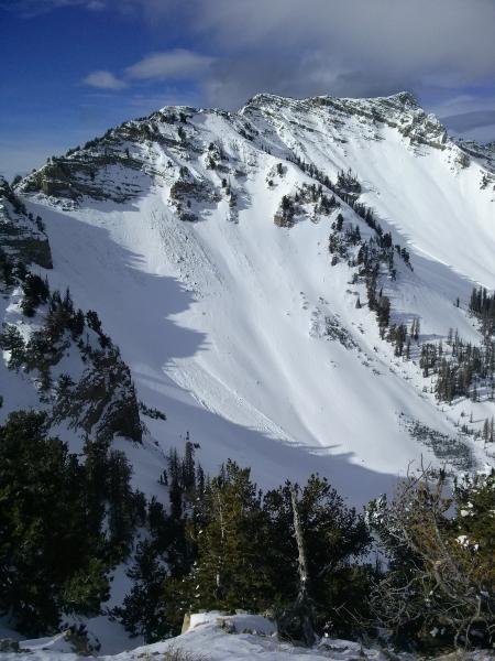
recent activity Some great info from the hard to reach Cascade ridge line in the Provo area mountains, which noted some natural activity in Bunnels. Ski area explosive work pried out a few stubborn wind slabs. Wind effected terrain, Cascade Ridge, Jackson Chandler photo.
|
| type | aspect/elevation | characteristics |
|---|

|

|
LIKELIHOOD
 LIKELY
UNLIKELY
SIZE
 LARGE
SMALL
TREND
 INCREASING DANGER
SAME
DECREASING DANGER
|
|
description
|
| type | aspect/elevation | characteristics |
|---|

|

|
LIKELIHOOD
LIKELY
UNLIKELY
SIZE
LARGE
SMALL
TREND
 INCREASING DANGER
SAME
DECREASING DANGER
|
|
description
The persistent weak layer problem is going nowhere fast - the obnoxious loose, sugary facets near the ground are fairly widespread on northerly facing, upper elevation slopes. Where they have a slab of snow on top, especially a wind slab, it is still possible for a person to trigger a slide breaking near the ground. This would most likely be from a thinner spot, such as the edges of the slab or over thinly covered rocks. Slides can be triggered from a distance or or from below. Collapsing and cracking are warning signs of a bad slab/weak layer combo. |
 |
weather The southern low is tracking through Arizona into New Mexico, and Wasatch mountains are on the far northern edge of the wrap around moisture. Today, mostly cloudy skies, with a few light snow flurries, but no real accumulation. The southeasterly winds will remain very light, averaging less than 10 mph. The winds will gradually shift to the northwest tonight and increase slightly. 10,000' temperatures today will be in the mid 20s, and cool into the upper teens tonight. The long term weather forecast is a bit discouraging - high pressure will dominate through mid week, after which there is little agreement as to whether the switch to a more westerly flow will produce any significant storms for northern Utah. |
| general announcements If you trigger an avalanche in the backcountry - especially if you are adjacent to a ski area – please call the following teams to alert them to the slide and whether anyone is missing or not. Rescue teams can be exposed to significant hazard when responding to avalanches, and do not want to do so when unneeded. Thanks. Salt Lake and Park City – Alta Central (801-742-2033), Canyons Resort Dispatch (435-615-3322) Twitter Updates for your mobile phone - DETAILS UDOT canyon closures UDOT at (801) 975-4838 Get your advisory on your iPhone with the Utah Avalanche Center mobile app, along with great navigation and rescue tools. Wasatch Powderbird Guides Blog/Itinerary for the Day. They'll be up and running later this winter - Remember your information can save lives. If you see anything we should know about, please participate in the creation of our own community avalanche advisory by submitting snow and avalanche conditions. You can also call us at 801-524-5304 or 800-662-4140, email by clicking HERE, or include #utavy in your tweet or Instagram. |


_3.jpg)
 The landscape is littered with hard wind drifts, mostly in upper elevation terrain, but they are also scattered on some mid elevation slopes, too. The unfamiliar easterly winds loaded these drifts in different places than normal, but they should be fairly easy to identify due to their smooth or slightly rippled texture and hardness. Avoid traveling on any drifts on steep slopes, especially on the northerly facing slopes, where they can be triggered from shallow spots and may break out above you.