| During the month of April, Mark Miller will donate $75 to the charity of your choice (5 to chose from, including the Utah Avalanche Center!) Mark Miller Subaru has raised over $300k in the previous 6 Do Good Feel Good events. More Info here |  |
| During the month of April, Mark Miller will donate $75 to the charity of your choice (5 to chose from, including the Utah Avalanche Center!) Mark Miller Subaru has raised over $300k in the previous 6 Do Good Feel Good events. More Info here | |
| Advisory: Provo Area Mountains | Issued by Drew Hardesty for Monday - November 18, 2013 - 7:42am |
|---|

|
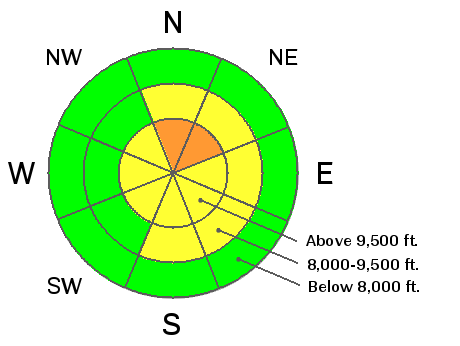
bottom line Pockets of CONSIDERABLE DANGER for human triggered avalanches exist on steep northerly through easterly facing slopes above roughly 7500-8000' in the Ogden mountains.) Avalanches may be triggered from a distance as well, breaking out 1-3' deep and a couple hundred feet wide. Collapsing and cracking are good clues to the instability. Best to stick to slopes less than 35 degrees in steepness and not connected to steeper terrain above. Remember that consequences will be more severe with a shallow snowpack as a victim gets dragged through thinly buried rocks and stumps.
|
 |
special announcement
Discount lift tickets will be for sale to benefit the Utah Avalanche Center shortly!!! - stay tuned. |
 |
current conditions What a difference a day makes. The skies cleared, winds lost some steam, and temps warmed into the 30s at many locations. But the riding conditions? Well, even Frank Luntz would struggle to put a spin on the riding conditions after Saturday night's winds had its way with the 12" reported at Sundance. Jim Harris put it well -
Note the statement in bold italics above. This is a key, maybe THE KEY to our current conditions in particular and terrain choices in general. The only terrain that holds (barely) enough snow to slide on is the terrain that is the most susceptible for avalanching (as you'll see in Recent Activity below). If I were speaking this, I would say this last sentence again. In essence, the Bull's Eye is that your terrain choices must be determined by the avalanche hazard. Low hazard? Aim for the side of the barn. High hazard? You've got to thread the needle. Otherwise, you're rolling the dice and in the end the House Always Wins...
|
 |
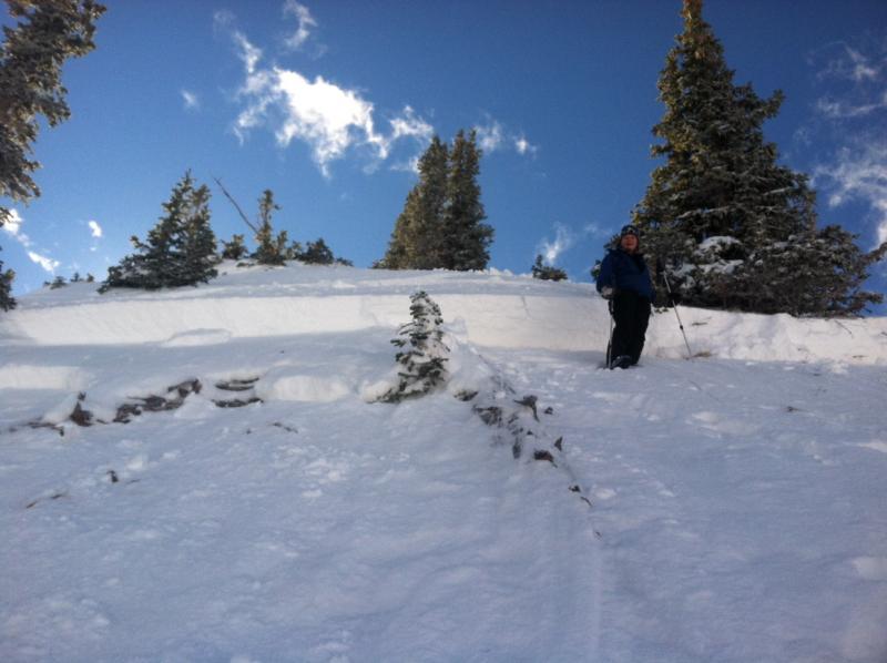
recent activity We didn't hear about any activity in the Provo mountains (as much terrain remains difficult to access); however we feel that the unstable snowpack there mirrors that in the Central Wasatch. In the central Wasatch - There were a few close calls yesterday - (place names hyperlinked to UAC Board Member Steve Achelis's Wasatch Backcountry Skiing page - try his iPhone app) Rocky Point (Alta/Brighton periphery) - a skier triggered and and was caught and carried in a 2-3' deep and 150' wide avalanche on a steep northerly facing slope at 10,400'. He lost and recovered some gear but escaped without injury. Photo (Evelyn Lees, below)
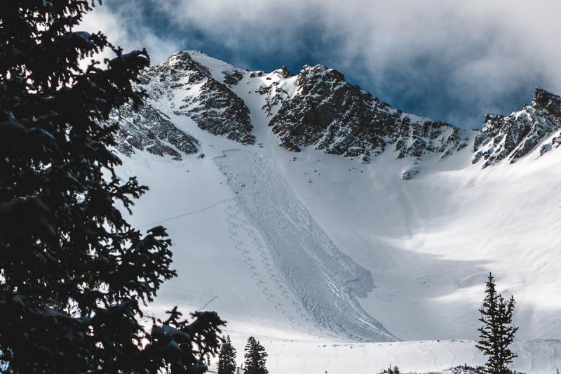
Cardiac Bowl - another close call took place in the heart of Cardiac Bowl yesterday. It's difficult to speculate on the events as we only received info from a party in another part of the Cardiff Fork. A rough estimate of dimensions is 3' deep and 70' wide, running over 400'. Cardiac Bowl is at roughly 10,600' on a north facing slope. Photo below (Jim Harris, below)
Other avalanches ripped out in the Ogden area mountains, the Western Uintas, as well as another in Rocky Point - they all fit the pattern - steep, upper elevation northerly terrain - and you can read more about them on our Observations Page - |
| type | aspect/elevation | characteristics |
|---|

|
|
LIKELIHOOD
 LIKELY
UNLIKELY
SIZE
 LARGE
SMALL
TREND
 INCREASING DANGER
SAME
DECREASING DANGER
|
|
description
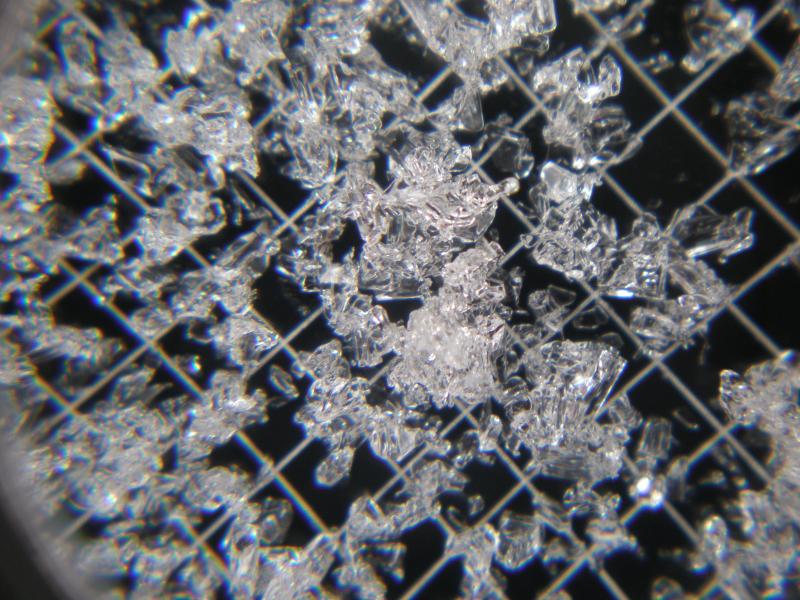
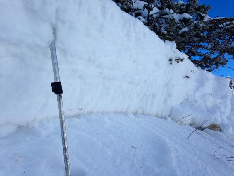
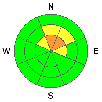
In the Provo area mountains, this poor structure may exist as low as 8000-8500' on the direct northerly facing slopes.....a bit lower than in the central Wasatch. Caution should be observed when travelling on north facing slopes...with collapsing a sure indicator of local instability. Well, the mousetrap was set. Weak snow (see Justin Lozier's photo below of the depth hoar crystals) formed in mid-October and buried by the October 28 wind/dirt storm has remained conditionally unstable, just waiting for the next (ie-Saturday's 12-18" plus wind) to show its hand. You can clearly see the dirt layer in Evelyn's photo below. While yesterday's sensitivity was ripe for human triggered slides, you'll need to give this house of cards a few more days to adjust before jumping into the steep northerly terrain. We sound like a broken record, but I'll say it again. " Persistent weaknesses aren't called that for nothin'." Other weaknesses abound from the early November storms (but at this point it's all academic - stay tuned)
Collapsing of the snowpack is a key piece of information with this snowpack structure; again triggering slides remotely, ie -from a distance remains - likely - |
| type | aspect/elevation | characteristics |
|---|

|

|
LIKELIHOOD
LIKELY
UNLIKELY
SIZE
 LARGE
SMALL
TREND
 INCREASING DANGER
SAME
DECREASING DANGER
|
|
description
Warmer temps and natural settlement will have strengthened both the storm snow and wind drifts; but it's worth playing conservative with the widely scattered wind whales that settled along - and well off - the ridgelines. They're more common on north through southeast facing slopes at the mid and upper elevations, but again - scattered due to the strength and variability of Saturday and Saturday night's winds. Remember wind drifts are smooth, rounded, and sometimes hollow sounding. |
| type | aspect/elevation | characteristics |
|---|

|

|
LIKELIHOOD
LIKELY
UNLIKELY
SIZE
 LARGE
SMALL
TREND
INCREASING DANGER
SAME
DECREASING DANGER
|
|
description
Hardly worth much mention (as few folks would consider being in this threadbare terrain), but sun/warming temps will soften and loosen up some of the sunlight slopes for some wet sluff potential. Would best be described as Pockets of Moderate - |
 |
weather Weak high pressure today will give way to a mild and moist westerly flow tomorrow through early Friday. A few inches of snow may be expected with "storm totals' by the end of the week adding up to a perhaps optimistic 6-10". By Friday, a cut-off Low develops and dives south, putting us into a breezy northeast flow. It remains spinning over the CA/Baja border over the weekend, ejecting northeast through central Utah early next week. For today, we'll see increasing high clouds with mountain temps reaching into the upper 30s/low 40s at 8000', the mid 30s at 10,000'. Winds will be in the 10-15mph range from the west and southwest. |
| general announcements If you trigger an avalanche in the backcountry - especially if you are adjacent to a ski area – please call the following teams to alert them to the slide and whether anyone is missing or not. Rescue teams can be exposed to significant hazard when responding to avalanches, and do not want to do so when unneeded. Thanks. Salt Lake and Park City – Alta Central (801-742-2033), Canyons Resort Dispatch (435-615-3322) Twitter Updates for your mobile phone - DETAILS UDOT canyon closures UDOT at (801) 975-4838 Get your advisory on your iPhone with the Utah Avalanche Center mobile app, along with great navigation and rescue tools. Remember your information can save lives. If you see anything we should know about, please participate in the creation of our own community avalanche advisory by submitting snow and avalanche conditions. You can also call us at 801-524-5304 or 800-662-4140, email by clicking HERE, or include #utavy in your tweet or Instagram. |


_3.jpg)