SPECIAL ANNOUNCEMENT |
 |
We will be doing intermittent afternoon avalanche advisories this week, as conditions change. We expect to update this again on Friday. |
|
|
BOTTOM LINE
Danger by aspect and elevation on slopes approaching 35° or steeper.
(click HERE for tomorrow's danger rating)
|
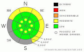
Danger Rose Tutorial
|
The avalanche danger is mostly LOW but we may have areas of MODERATE danger of wet, loose-snow sluffs especially at lower elevations if there is significant rain today. If substantially more than the few inches of snow fall at upper elevation, or if the winds blow hard, you can bump the avalanche danger up to MODERATE in those areas. |
|
|
CURRENT CONDITIONS |

|
We got a little bit of snow yesterday morning--1-4 inches with the most at Alta, as usual. The snow settled quickly because it fell on a wet, warm, snow surface and the afternoon sun helped to cook it down. The forecast is for 1-2 more inches of wet snow today with rain to 8,000.

Here is the SNOTEL plot from Brighton. The red line is last season, the blue line is average, one of the green lines is 2007, the next lowest snow year to date. The green line that stops at the present time is this season. At least for the Brighton station, this is the lowest snow year on their record but it does not include the very low snow year of 1976-77, which is probably barely lower. |
|
|
RECENT ACTIVITY |

|
No activity has been reported since the weekend except for minor loose snow sluffs today within the new snow with daytime heating.
Remember you can always check for recent observations or avalanche activity report sent in by the general public or our forecasters on our Current Conditions page. |
|
|
THREAT #1 |

|
| WHERE |
PROBABILITY |
SIZE |
TREND |
|
|
|
|
| |
|
|
Over the next
24 hours.
|
|
|
There has not been many reports lately and our staff is busy working on spring projects, so the only observations we have are from the few ski resorts still open. They are reporting mostly stable conditions with low to moderate danger. The only activity reported was some wet loose snow sluffs due to sun heating of the new snow.
Caveat: spring weather forecasting is always very difficult because of the convective nature of the weather. especially in spring, avalanche danger depends on weather so our avalanche advisory usually contains what computer programmers call IF-THEN statements. IF we get substantially more than the 2-3 inches forecast today, or if the wind blows much more than forecast, THEN you can expect some activity within the new snow such as soft slabs or wind slabs. The rain-snow line is supposed to be around 8,000', so the rain on the lower elevation snowpack may cause wet avalanche activity such as loose snow sluffs. As always, you should jump on test slopes or test how well the new snow is bonded or check if the snow is saturated with water as you travel by occasionally digging down with your hand.
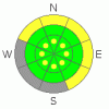
Note: the grey areas on the danger rose above indicate bare ground. |
|
|
MOUNTAIN WEATHER |

|
The forecast if for another weak disturbance today, which should give us another 1-3 inches of new snow up high and rain below about 8,000'. The wind is not expected to blow very hard, 15 mph from the south. The daytime high should be around 40 degrees. We should have continued unsettled weather linger into Thursday but they it looks like a strong warm up for the weekend, when we will have to worry about more widespread wet avalanche activity.
Be sure to monitor the National Weather Service for the current weather forecast and monitor the Snow Page for current weather conditions. |
|
|
GENERAL ANNOUNCEMENTS |
GENERAL ANNOUNCEMENTS
If you trigger an avalanche in the backcountry - especially if you are adjacent to a ski area – please call the following teams to alert them to the slide and whether anyone is missing or not. Rescue teams can be exposed to significant hazard when responding to avalanches, and do not want to do so when unneeded. Thanks.
Salt Lake and Park City – Alta Central (801-742-2033)
Ogden – Snowbasin Patrol Dispatch (801-620-1017)
Provo – Sundance Patrol Dispatch (801-223-4150)
Twitter Updates for your mobile phonehttp://utahavalanchecenter.org/twitter)
Daily observations are frequentlypostedby 10 pm each evening.
Subscribe to the daily avalanche advisory e-mail click HERE.
UDOT canyon closuresUDOTat(801) 975-4838
Remember your information can save lives.If you see anything we should know about, please participate in the creation of our own community avalanche advisory by submittingavalanche and snow observations. You can also call us at801-524-5304or800-662-4140, or email by clicking HERE
Donate to your favorite non-profit –The Friends of the Utah Avalanche Center. The UAC depends on contributions from users like you to support our work.
We will update this forecast on an intermittent basis as needed. |
|
|
This information does not apply to developed ski areas or highways where avalanche control is normally done. This advisory is from the U.S.D.A. Forest Service, which is solely responsible for its content. This advisory describes general avalanche conditions and local variations always occur. |
|
This advisory provided by the USDA Forest Service, in partnership with:
The Friends of the Utah Avalanche Center, Utah Division of State Parks and Recreation, Utah Division of Emergency Management, Salt Lake County, Salt Lake Unified Fire Authority and the friends of the La Sal Avalanche Center. See our Sponsors Page for a complete list. |
