SPECIAL ANNOUNCEMENT |
 |
Hot tip: we still have some discount lift tickets for Snowbird, Alta, Deer Valley, Brian Head, and Sundance available through Backcountry.com, which you can find HERE. |
|
|
BOTTOM LINE
Danger by aspect and elevation on slopes approaching 35° or steeper.
(click HERE for tomorrow's danger rating)
|
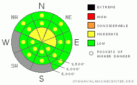
Danger Rose Tutorial
|
The avalanche danger is mostly LOW, with a MODERATE danger remaining on steep, upper elevation, northwest through easterly facing slopes, where in very isolated places a person could still trigger a deeper slab avalanche, likely from a shallow snow pack area. In addition, there are Pockets of MODERATE danger for triggering a wet loose sluff or a shallow wind slab.
|
|
|
CURRENT CONDITIONS |

|
Under partly cloudy skies, it’s a very balmy spring morning, with mountain temperatures in the low 30s to low 40s. A few snow showers last yesterday brought a trace of snow to most locations, with up to an inch of snow in the Ogden area mountains. Across the highest peaks, the southwesterly winds increased into the 25 to 35 mph range, with gusts in the 40s. At mid elevations, 10 to 20 mph averages are more common.
There is a good, supportable base for riding, with fast, smooth turning conditions in very shallow powder on upper elevation northerly facing slopes. The early morning crusts will soften rapidly today. |
|
|
RECENT ACTIVITY |

|
Wednesday night’s few inches of snow was blown into shallow, sensitive wind drifts, which were easy to spot and easy to trigger with slope cuts in the White Pine and Mary Ellen drainages of the Salt Lake mountains. The largest reported was 4 to 6” deep by 150’ wide. |
|
|
THREAT #1 |

|
| WHERE |
PROBABILITY |
SIZE |
TREND |

|
|
|
|
| |
|
|
Over the next
12 hours.
|
|
|
Predictable, wet avalanche concerns move to the top of the list this morning. A jump in temperatures will make the newest few inches of snow sensitive on steep slopes, including northerly facing slopes. Once the snow becomes damp, it will be easy to initiate roller balls and sluffs, and you don’t want to get mowed over by a sluff of your own creation. Avoid continuously steep slopes, chutes and gullies without escapes once the snow heats up. |
|
|
THREAT #2 |

|
| WHERE |
PROBABILITY |
SIZE |
TREND |

|
|
|
|
| |
|
|
Over the next
24 hours.
|
|
|
There are a scattering of both new and old wind drifts that can be triggered by a person, mostly along the higher elevation ridge lines. These drifts are shallow, and mostly an issue if you were caught by surprise, knocked off balance or sent over a cliff. Cornices overhang much further than you would think, and can break back and pull snow off of what appear to be flat ridgelines. |
|
|
THREAT #3 |

|
| WHERE |
PROBABILITY |
SIZE |
TREND |

|
|
|
|
| |
|
|
Over the next
24 hours.
|
|
|
And finally, approach steep, upper elevation, northerly facing slopes with skepticism, as avalanches breaking on a deeper layer within the snow pack are still possible in very isolated places. The most suspect slopes are those with a shallow pack and that are very steep and rocky, including slopes which have already slid this year. |
|
|
MOUNTAIN WEATHER |

|
Strengthening high pressure ahead of a fast moving Pacific storm slated for Saturday night has northern Utah under an increasingly warm, windy southwesterly flow today and tomorrow. Temperatures today will warm into the low 50s at 8,000’ and upper 30s at 10,000’. Winds will remain from the southwest, with the highest peaks in the 20 to 30 mph range, with gusts in the 40’s to 50s. Mid elevation wind speeds will average 10 to 20 mph, with gusts in the 20s and 30s.
Saturday will be even warmer and very windy, with 10,000’ highs in the low to mid 40s and the southwesterly winds peaking in the afternoon, in the 45 to 55 mph range. The quick moving cold front will cross the northern mountains Saturday night, plunging temperatures into the teens and brining a shot of snow, in the 3 to 6” range. |
|
|
GENERAL ANNOUNCEMENTS |
If you trigger an avalanche in the backcountry - especially if you are adjacent to a ski area – please call the following teams to alert them to the slide and whether anyone is missing or not. Rescue teams can be exposed to significant hazard when responding to avalanches, and do not want to do so when unneeded. Thanks.
Salt Lake and Park City – Alta Central (801-742-2033)
Ogden – Snowbasin Patrol Dispatch (801-620-1017)
Provo – Sundance Patrol Dispatch (801-223-4150)
Dawn Patrol Forecast Hotline, updated by 05:30: 888-999-4019 option 8.
Twitter Updates for your mobile phone http://utahavalanchecenter.org/twitter)
Daily observations are frequently posted by 10 pm each evening.
Subscribe to the daily avalanche advisory e-mail click HERE.
UDOT canyon closures UDOT at (801) 975-4838
Wasatch Powderbird Guides does daily updates about where they'll be operating on this blog http://powderbird.blogspot.com/.
Remember your information can save lives.If you see anything we should know about, please participate in the creation of our own community avalanche advisory by submitting avalanche and snow observations. You can also call us at 801-524-5304 or 800-662-4140, or email by clicking HERE
Donate to your favorite non-profit –The Friends of the Utah Avalanche Center. The UAC depends on contributions from users like you to support our work.
We will update this forecast tomorrow morning. Thanks for calling. |
|
|
This information does not apply to developed ski areas or highways where avalanche control is normally done. This advisory is from the U.S.D.A. Forest Service, which is solely responsible for its content. This advisory describes general avalanche conditions and local variations always occur. |
|
This advisory provided by the USDA Forest Service, in partnership with:
The Friends of the Utah Avalanche Center, Utah Division of State Parks and Recreation, Utah Division of Emergency Management, Salt Lake County, Salt Lake Unified Fire Authority and the friends of the La Sal Avalanche Center. See our Sponsors Page for a complete list. |
