SPECIAL ANNOUNCEMENT |
 |
We need your help! Would you like a great mobile avalanche app? A new, slick website look? A better, easier-to-use information network? And something that all avalanche centers can use? There could be an app for that.
We are applying for a grant to help unify our website, email, SMS, and social media alerts and create an open source platform that could be used by any avalanche center. Check out the link. Click the Like button to vote for the project and spread this among your friends. The grant is awarded based on the number of votes:
http://bit.ly/FRcRsM
Hot tip: we still have some discount lift tickets for Snowbird and Alta available through Backcountry.com, which you can find HERE.
|
|
|
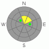
BOTTOM LINE
Danger by aspect and elevation on slopes approaching 35° or steeper.
(click HERE for tomorrow's danger rating)
|

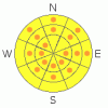
Danger Rose Tutorial
|
The avalanche danger is Moderate this morning, but will quickly rise to pockets of CONSIDERABLE on and below any steep slope that receives direct sun and or heating from high thin clouds. Any overnight refreeze of the snow will be very shallow, so get out early, and be off of and out from under steep slopes by around 10 am. Both wet loose slides and wet slab avalanches are possible.
There continue to be isolated places where deeper, dry slab avalanche can be triggered on steep, upper elevation, northerly facing slopes with a shallow snow pack, including slopes that have slide this year.
|
|
|
CURRENT CONDITIONS |

|
The unreasonable, unseasonable warm temperatures continue, assisted by overnight, insulating high clouds. This morning, most stations in the Provo area mountains are 5 to 10 degrees warmer than yesterday morning, in the mid 30s to upper 40s. The only spots to dip below freezing are the above 10,000' peaks.. The southwesterly winds also increased overnight, with 20 to 35 mph averages across the exposed terrain, and gusts in the 40s. Any surface refreeze will be very shallow and short lived this morning.
|
|
|
RECENT ACTIVITY |

|
Roller balls and wet loose sluffs were the only reported activity yesterday from the relatively empty backcountry.
|
|
|
THREAT #1 |

|
| WHERE |
PROBABILITY |
SIZE |
TREND |
|
|
|
|
| |
|
|
Over the next
12 hours.
|
|
|
Wet avalanches remain the number one concern today. Expect both natural and easily triggered wet loose sluffs on all steep, sunny slopes today. The snow on northerly facing slopes will also sluff easily, with the periods of high, thin clouds adding additional heat into the snow pack. Wind is the only cooling element on our side today, and even that will decrease this afternoon.
We may even have the start of a wet slab avalanche cycle today. It often takes multiple non-freezing days and nights for wet slab avalanches to occur. However, the widespread nature and number of weak layers and ice crusts in the snowpack where water can pool makes me suspect it may take less time. A larger trigger like a wet sluff could gouge to the ground in wet facets or trigger a wet slab avalanche mid pack. Plan your backcountry travel carefully – avoid travel on and below steep slopes, especially in or above gullies or on slopes that funnel. Wet snow avalanche debris sets up like concrete.
|
|
|
THREAT #2 |

|
| WHERE |
PROBABILITY |
SIZE |
TREND |
|
|
|
|
| |
|
|
Over the next
24 hours.
|
|
|
Four deeper slab avalanches have been triggered in the past 4 days, two explosive triggered at resorts and two human triggered in the backcountry, out of all the heavily traveled slopes. This illustrates the very isolated chance of triggering a slide on one of the old weak layers near the ground. The most suspect slopes are those with a very shallow pack, slopes which have already slid this year, or that are very steep and rocky.
|
|
|
MOUNTAIN WEATHER |

|
Another scorcher of a day, with temperatures warming into the 50s at 8,000’ and to near 40 at 10,000’. The southwesterly winds will remain strong this morning, peaking around noon, before decreasing this afternoon. This morning, speeds will average in the 25 to 35 mph range, with gusts to 50 across the highest peaks, and 15 to 25 mph averages at the mid elevations. Cloud cover will be variable today – mostly intermittent high, thin clouds, with periods of full sun. Temperatures will continue to be very warm day and night through Sunday, with the southerly winds increasing again on Sunday ahead of a quick hitting cold front. This front Sunday night into Monday will bring a small shot of snow and cooler temperatures.
|
|
|
This information does not apply to developed ski areas or highways where avalanche control is normally done. This advisory is from the U.S.D.A. Forest Service, which is solely responsible for its content. This advisory describes general avalanche conditions and local variations always occur. |
|
This advisory provided by the USDA Forest Service, in partnership with:
The Friends of the Utah Avalanche Center, Utah Division of State Parks and Recreation, Utah Division of Emergency Management, Salt Lake County, Salt Lake Unified Fire Authority and the friends of the La Sal Avalanche Center. See our Sponsors Page for a complete list. |
