Provo Avalanche Advisory

Forecaster: Drew Hardesty

AVALANCHE WARNING »

Dangerous avalanche conditions are occuring or are imminent. Backcountry travel in avalanche terrain is not recommended.
Notice:

THIS AVALANCHE WARNING IS FOR THE MOUNTAINS OF NORTHERN AND CENTRAL UTAH, TO INCLUDE THE BEAR RIVER RANGE, THE WESTERN UINTAS AND THE WASATCH PLATEAU. RAPID WARMING AND DIRECT SUN WILL CREATE DANGEROUS AND UNSTABLE AVALANCHE CONDITIONS. NATURAL AND HUMAN TRIGGERED AVALANCHES ARE LIKELY. BACKCOUNTRY TRAVEL ON OR BELOW STEEP MOUNTAIN SLOPES IS NOT RECOMMENDED OVER THE NEXT FEW DAYS.


SPECIAL ANNOUNCEMENT

UDOT will conduct avalanche control work on the north side of Little Cottonwood canyon and Alta snow safety teams will conduct avalanche control work in and above Grizzly Gulch and Patsy Marley. Uphill traffic in all of this terrain will be restricted until they're finished. Remember these - all - snow safety teams assume a great deal of risk to make conditions safe for the recreating public - please respect their closures. You can get more information from UDOT at (801) 975-4838.


BOTTOM LINE

Danger by aspect and elevation on slopes approaching 35° or steeper.
(click HERE for tomorrow's danger rating)


Danger Rose Tutorial

A HIGH danger exists in the backcountry. Natural and human triggered wet and dry avalanches up to 5’ deep are likely with daytime warming. Remotely triggered slides remain likely on a variety of aspects and elevations. Travel on or beneath steep mountain terrain is not recommended.


CURRENT CONDITIONS

Skies are clearing and the northwesterly winds have dropped down to less than 15mph at all but the 11,000’ ridgelines. Temperatures have spiked at least 15 degrees in their upward march into the mid 30s to low 40s today. Greenhousing put something of a wet blanket on much of the cold snow yesterday, but for this season, coverage and riding conditions are 5 star.

These are dangerous times, friends. Books and books have been written about our inability to adjust or adapt to change. Today’s direct sun and rapid warming will dramatically alter the ‘mechanics’ of our conditionally unstable, layered snowpack in northern and central Utah. I don’t like it.

It was a little over a month ago – January 28th – that I wrote on that morning’s advisory -

“It’s gonna be one of those days - Bluebird, light wind, 5 star powder (for this year anyway). Truth be told, it’s also days like these where we see avalanche accidents. Discipline, self-denial – these are things we not only aspire to – it’s what keeps us alive in conditions like these.”

Sadly, it proved true – we suffered our 2nd fatality of the year that day on Kessler Peak above Big Cottonwood Canyon. Today – Sunday March 4th – will be much the same.


RECENT ACTIVITY

Rescue teams in the La Sals are looking for a missing snowmobiler buried in a significant avalanche debris pile. You can check the updated Accident Report in progress here and all the individual reports of avalanches here.

Other naturals from two days ago have been reported in the Finger's area above Sundance. This over and above the remote in Trailer Court also from two days ago. See Trailer court ob in Current conditions for more info.

In the Central Wasatch, numerous human triggered avalanches filtered in – one near Mt. Aire that snapped trees in the runout 1200’ below, one with control work in the mid-canyon that left a debris pile 6’ deep and 60’ wide on Little Cottonwood road, one that reportedly resulted a full burial and live recovery in Porter Fork of Mill Creek. The details –

· Lambs Canyon – a ski cut released a 2-3’ deep and 300’ wide avalanche on a northeast facing slope at 8200’.

· Reynolds East face shoulder - A snowboarder descending the ridge remotely triggered a 2-3’ deep and 300’ wide avalanche there at 9300’ on the east-southeast face.

· Mineral Fork of BCC – a skier descending a steep west facing slope at 8500’ between Kessler and East Mineral remotely triggered a 2-3’ deep and 125’ wide avalanche.

· West Willow Heights – either natural, cornice, or remotely triggered slide pulled out a slab estimated at 3-5’ deep and upwards of 1000’ wide on a steep east to northeast facing slope at 9600’.

· West Porter of Mill Creek – likely remotely triggered slide on the headwall pulling out 2-3’ deep and 300’ wide in the steep northeast facing headwall. Overran the skin track.

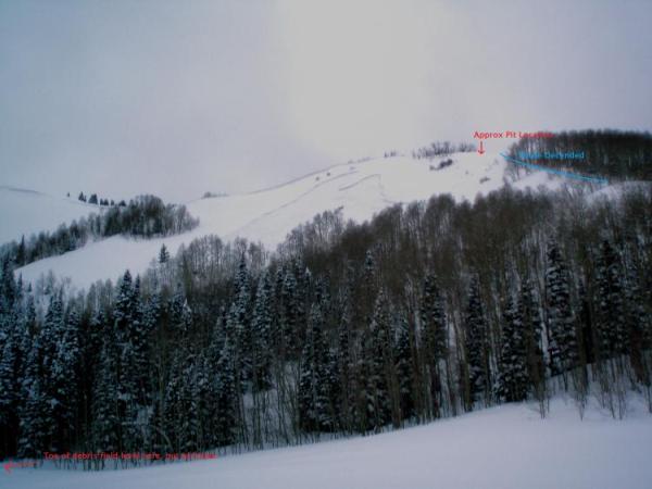
· Porter Fork of Mill Creek – sketchy details of a full burial and live recovery.

· Mt Aire – a cornice drop remotely triggered a 3’ deep and 75’ wide avalanche, snapping 6” dbh trees 1200’ below. It was on a steep east facing slope at 8500’.

· Brighton Backcountry above Lake Mary – ski cut pulls out a 2’ deep 50’ wide slide on a northeast facing slope above 10k.

· West Monitor – few details on a slide in the bowl – west facing at 9500’ 2’ deep and 100’ wide.

Reynolds pic (Clarke photo below)

Mineral slide (Adler photo) below


THREAT #1

WHERE PROBABILITY SIZE TREND
      Over the next 12 hours.

The persistent slabs are not reacting well at all to 30-50” of snow and alternating strong southerly and then northwesterly winds from the last couple of weeks. And now we’re shocking the system with high, direct sun and temps spiking toward 30 degrees. Human triggered slides – even remotely triggered slides – remain likely on all aspects. They’ve been most common on northeast to southeast facing slopes above 9000’, yet collapsing persists on due south as well. These we can anticipate to some degree. Still – the outliers on due south and southwest (last Sat/Sun) and low elevation – Summit Park < 8000’ northerly on Tuesday should inspire caution in all terrain. While the bulk of the natural avalanching is over, dangerous conditions remain.

Snow is the coolest thing on earth – along with many other things, it’s described as having ‘Visco-Elastic’ properties. That is, like honey, the upper warmed portion will start to ooze, or creep downhill, exacerbating the already stressed weak interfaces until it snaps – or – more aptly – avalanches. It’s why we sometimes see natural deep releases on days with rapid warming and direct sun.


THREAT #2

WHERE PROBABILITY SIZE TREND
      Over the next 12 hours.

Wet avalanches will be a major concern with natural and human triggered slides certain on any and all steep southerly facing slopes with daytime warming. Lower elevation northerly slope are also suspect as they become damp and unstable.


THREAT #3

WHERE PROBABILITY SIZE TREND
      Over the next 12 hours.

There are other significant concerns – yawning CORNICES will be increasingly sensitive and may calve off naturally, releasing large avalanches below. ROOF-A-LANCHES are also a significant concern for home-owners – this is a serious concern that has led to many close calls, burials, and even one fatality – a forest service employee - in Girdwood Alaska roughly ten years ago. Lastly, the gullies above the ice climbing routes in the range are suspect with today’s heating. Put the tools away until it cools off later this week.


MOUNTAIN WEATHER

Clearing skies, light wind, and soaring temps. We’ll see 10k temps march to near 30 degrees while 8000’ temps crest 40 degrees. The next two days will also be warm ahead of a storm for Tuesday night.


GENERAL ANNOUNCEMENTS

If you trigger an avalanche in the backcountry - especially if you are adjacent to a ski area – please call the following teams to alert them to the slide and whether anyone is missing or not. Rescue teams can be exposed to significant hazard when responding to avalanches, and do not want to do so when unneeded. Thanks.

Salt Lake and Park City – Alta Central (801-742-2033)

Ogden – Snowbasin Patrol Dispatch (801-620-1017)

Provo – Sundance Patrol Dispatch (801-223-4150)

Dawn Patrol Forecast Hotline, updated by 05:30: 888-999-4019 option 8.

Twitter Updates for your mobile phone http://utahavalanchecenter.org/twitter)

Daily observations are frequently posted by 10 pm each evening.

Subscribe to the daily avalanche advisory e-mail click HERE.

UDOT canyon closures UDOT at (801) 975-4838

Wasatch Powderbird Guides does daily updates about where they'll be operating on this blog http://powderbird.blogspot.com/ .

You have the opportunity to participate in the creation of our own community avalanche advisory by submitting avalanche and snow observations. You can also call us at 801-524-5304 or 800-662-4140, or email by clicking HERE

Donate to your favorite non-profit –The Friends of the Utah Avalanche Center. The UAC depends on contributions from users like you to support our work.

We will update this forecast tomorrow morning. Thanks for calling.


This information does not apply to developed ski areas or highways where avalanche control is normally done.  This advisory is from the U.S.D.A. Forest Service, which is solely responsible for its content. This advisory describes general avalanche conditions and local variations always occur.


This advisory provided by the USDA Forest Service, in partnership with:

The Friends of the Utah Avalanche Center, Utah Division of State Parks and Recreation, Utah Division of Emergency Management, Salt Lake County, Salt Lake Unified Fire Authority and the friends of the La Sal Avalanche Center. See our Sponsors Page for a complete list.