AVALANCHE WARNING »
Dangerous avalanche conditions are occuring or are imminent.
Backcountry travel in avalanche terrain is not recommended.
|
 |
Notice: This avalanche warning is for the mountains of northern and central Utah effective from noon today through Thursday. Strong winds and heavy snowfall today and tonight will increase the avalanche danger… first in the mountains north of I-80 as of noon today. The danger will rise to HIGH in the mountains south of I-80…the western Uintas and the central Utah mountains tonight through Thursday. Dangerous backcountry avalanche conditions are developing and will remain elevated through Thursday. |
|
|
BOTTOM LINE
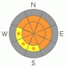
Danger by aspect and elevation on slopes approaching 35° or steeper.
(click HERE for tomorrow's danger rating)
|

Danger Rose Tutorial
|
Strong winds today, with heavy snowfall and intense winds this evening and tonight, are creating an increasingly dangerous avalanche danger. The avalanche danger is CONSIDERABLE this morning on all mid and upper elevation steep, wind drifted slopes. The danger will rise to HIGH later this afternoon or tonight, with frontal passage, when the strongest winds and heaviest snowfall will occur.
Once again, as the storm intensifies, avoid all steep slopes, especially if they are recently wind drifted. Also avoid travel below steep slopes, as natural avalanches could occur, especially overnight, and be triggered remotely from below.
Wind sheltered, low angle slopes that are not connected to or beneath steep slopes provide the safer terrain today. |
|
|
CURRENT CONDITIONS |

|
The winds are crashing yesterday’s powder party. They are blowing from the southwest, and have already ramped up into the 15 to 25 mph range, with gusts to 40 mph, with some of the high peaks are averaging 45 with gusts into the 50s. Temperatures have warmed slightly, with most stations in the mid teens to mid twenties. Yesterday’s storm totals were 9 to 16 inches in the Salt Lake, Park City and Provo area mountains, with 3 to 6” in the Ogden area mountains. |
|
|
RECENT ACTIVITY |

|
 Most backcountry parties near any steep terrain triggered sensitive new snow soft slabs yesterday, some remotely, averaging 100-200' wide, on aspects including southeast, east and northerly. Two slides broke out 2 ½ feet deep, on north and northwest facing slopes, probably into older snow - Davenport in Silver Fork at 10,000' and in Summit Park, 7,700'. In south Monitor bowl, a slide was triggered remotely on a SE facing slope that probably involved one of the facet/crust layers. Most backcountry parties near any steep terrain triggered sensitive new snow soft slabs yesterday, some remotely, averaging 100-200' wide, on aspects including southeast, east and northerly. Two slides broke out 2 ½ feet deep, on north and northwest facing slopes, probably into older snow - Davenport in Silver Fork at 10,000' and in Summit Park, 7,700'. In south Monitor bowl, a slide was triggered remotely on a SE facing slope that probably involved one of the facet/crust layers.
|
|
|
THREAT #1 |

|
| WHERE |
PROBABILITY |
SIZE |
TREND |

|
|
|
|
| |
|
|
Over the next
24 hours.
|
|
|
Steadily deepening wind drifts will be the number one avalanche issue today – the already moderate to strong southerly winds have lots of snow available to transport into sensitive drifts. Wind speeds are forecast to increase mid day, and then again with the evening frontal passage, when they will shift to the west and the northwest, and remain strong. These wind drifts can be triggered remotely from a distance. |
|
|
THREAT #2 |

|
| WHERE |
PROBABILITY |
SIZE |
TREND |
|
|
|
|
| |
|
|
Over the next
24 hours.
|
|
|
We are in the process of putting a series of Wasatch storms on top of our weak “Colorado” (continental) snow pack, and this is a bad mix. The additional snow will overload the weak layers both mid pack and near the ground. Today, wind drifted slopes are the most likely place to trigger one of these deeper, dangerous slides. Also, a new snow slide has the potential to step down and trigger a deeper slide. Any slide breaking out into these deeper weak layers has the potential to be unsurvivable, with debris piles 6 to 8 feet deep. Slopes with a thin snowpack, including those that have slid one or more time this year and some of the mid elevation slopes, generally have the weakest snow. Slides can be triggered remotely from a distance.
Unusual for mid winter Wasatch are the number of weak layers on the more southerly facing slopes - facets associated with any number of crusts, in addition to the more usual faceted layers on the northerly facing slopes. |
|
|
MOUNTAIN WEATHER |

|
A Pacific storm is bearing down, with frontal passage forecast to reach northern Utah this afternoon or early evening. Strong southerly winds ahead of the storm will continue today, accompanied by 3 to 6 inches of snow. Winds will shift to west with the front and then northwest, remaining strong into early Thursday. The storm will intensify late this afternoon or early this evening around frontal passage, with several hours of heavy snowfall, and a total of 8 to 12 inches tonight. |
|
|
GENERAL ANNOUNCEMENTS |
If you trigger an avalanche in the backcountry - especially if you are adjacent to a ski area – please call the following teams to alert them to the slide and whether anyone is missing or not. Rescue teams can be exposed to significant hazard when responding to avalanches, and do not want to do so when unneeded. Thanks.
Salt Lake and Park City – Alta Central (801-742-2033)
Ogden – Snowbasin Patrol Dispatch (801-620-1017)
Provo – Sundance Patrol Dispatch (801-223-4150)
Dawn Patrol Forecast Hotline, updated by 05:30: 888-999-4019 option 8.
Twitter Updates for your mobile phone http://utahavalanchecenter.org/twitter)
Daily observations are frequently posted by 10 pm each evening.
Subscribe to the daily avalanche advisory e-mail click HERE.
UDOT canyon closures UDOT at (801) 975-4838
Wasatch Powderbird Guides does daily updates about where they'll be operating on this blog http://powderbird.blogspot.com/ .
You have the opportunity to participate in the creation of our own community avalanche advisory by submitting avalanche and snow observations. You can also call us at 801-524-5304 or 800-662-4140, or email by clicking HERE
Donate to your favorite non-profit –The Friends of the Utah Avalanche Center. The UAC depends on contributions from users like you to support our work.
We will update this forecast tomorrow morning. Thanks for calling. |
|
|
This information does not apply to developed ski areas or highways where avalanche control is normally done. This advisory is from the U.S.D.A. Forest Service, which is solely responsible for its content. This advisory describes general avalanche conditions and local variations always occur. |
|
This advisory provided by the USDA Forest Service, in partnership with:
The Friends of the Utah Avalanche Center, Utah Division of State Parks and Recreation, Utah Division of Emergency Management, Salt Lake County, Salt Lake Unified Fire Authority and the friends of the La Sal Avalanche Center. See our Sponsors Page for a complete list. |
