SPECIAL ANNOUNCEMENT |
 |
Join us for the 10th
Wasatch Powderkeg
on Mar 10 @
Brighton Resort
. This event is a fundraiser for the UAC. This year there will be some course and category changes and, as always, a great group, prizes, beacon demos, and post-race party. Register by Mar 1 to get a race tshirt. Details at
http://wasatchpowderkeg.com/ |
|
|
BOTTOM LINE
Danger by aspect and elevation on slopes approaching 35° or steeper.
(click HERE for tomorrow's danger rating)
|
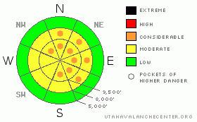
Danger Rose Tutorial
|
A current Considerable danger from this morning's storm snow should drop to Moderate by the afternoon - human triggered slides will be possible. Pockets of CONSIDERABLE danger remain due to the complexity and widespread nature of lingering persistent and deep slab instabilities. Now that all aspects are suspect, your only trump card is choosing gentler terrain with nothing steeper above. Complexity and uncertainty should drive cautious decision making. Consider the Munter, Jamieson graph below.

|
|
|
CURRENT CONDITIONS |

|
The storm gathered steam overnight - storm totals as of 5am are 8". Densities are roughly 8-9%. Winds, while punishing yesterday, are 20-25mph from the west to southwest. They've been veering from south to southwest to west as the storm moves overhead. Temps are in the low twenties. Skiing and riding conditions should be vastly improved. |
|
|
RECENT ACTIVITY |

|
Tom Wolfe's 1940 novel You Can't Go Home Again details a young man's striking out from comfort and security of home and making his way in the world. Years later, with some acceptance of impermanence, he declares "You can't go back home to your family, back home to your childhood ... back home to a young man's dreams of glory and of fame.."......And so it is with this winter. When typically safe mid-winter aspects south and southwest produce remotely triggered slides (see Sunday's Cardiff Pass remote and Saturday's Dry Fork remote), it really feels like You Can't Go Home Again.
With a complex set of avalanche issues from Deep Slab to two sets of Persistent Slab (weaknesses buried Feb 8th and Feb 19th), I had to take something from Evelyn's playbook and create an avalanche occurrence rose to wrap my head around the pattern and distribution. Clearly, there is a pattern (north through easterly)...but note the Outliers (south through west). Throw Familiarity out the window - old stand-by safe areas are not what they used to be. Tom Wolfe had it right all along.
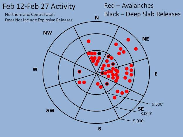
We heard of no activity yesterday save for some shallow stiff wind slabs from control work. |
|
|
THREAT #1 |

|
| WHERE |
PROBABILITY |
SIZE |
TREND |
|
|
|
|
| |
|
|
Over the next
24 hours.
|
|
|
Absent any wind, Instability within the new storm snow should be peaking now (6-8am). Barring a blown weather forecast - never happens - conditions within the storm snow should recover and start to stabilize throughout the day. Early morning reports indicate some intra-storm weaknesses that will warrant some attention and require smart terrain management and safe travel protocol. You'll have to be your own spot-"now-caster" - storm snow avalanche instability follows periods of heavier snowfall and gustier winds. Test slopes and slope cuts will be useful. Be mindful of longer running sluffs. |
|
|
THREAT #2 |

|
| WHERE |
PROBABILITY |
SIZE |
TREND |

|
|
|
|
| |
|
|
Over the next
24 hours.
|
|
|
Left to their own devices, these persistent weaknesses from the 11th and 19th would lie mostly dormant. A week of strong northwest and then southerly winds (along with a few inches of graupel, etc) was plenty to reactivate these interfaces. There just wasn't enough time, arguably, for the glue to dry. Tomorrow's forecasted winds and mid to late week snowfall should continue tugging at these persistent weak layers - present on all aspects.
Collapse failure within a heavily layered/structured snowpack will still produce remotely triggered slides. This potential should make one reassess safe zones adjacent to, and below the actual run. Collapsing and cracking on low angle slopes is more than enough evidence to take a rain check. |
|
|
THREAT #3 |

|
| WHERE |
PROBABILITY |
SIZE |
TREND |

|
|
|
|
| |
|
|
Over the next
24 hours.
|
|
|
Low Probability, High Consequence. It may be difficult for a single person to trigger one of these; however, a group on a slope, a group of snowmobilers on a slope, or another avalanche (see above) may be enough to crow-bar out one of the deeper slabs. |
|
|
MOUNTAIN WEATHER |

|
We should have just a few more inches of snow this morning accompanied by gusty west veering to northwest winds. Temps will be in the low teens; winds 15-20mph along the highest peaks. A weak shortwave ridge builds for tonight ahead of what looks to be a powerful storm tomorrow through Friday. Strong southwest winds tomorrow precede Wednesday night's crashing cold front. Good potential for significant accumulations. Consideration will be for an Avalanche Watch.... |
|
|
GENERAL ANNOUNCEMENTS |
If you trigger an avalanche in the backcountry - especially if you are adjacent to a ski area – please call the following teams to alert them to the slide and whether anyone is missing or not. Rescue teams can be exposed to significant hazard when responding to avalanches, and do not want to do so when unneeded. Thanks.
Salt Lake – Alta Central (801-742-2033)
Ogden – Snowbasin Patrol Dispatch (801-620-1017)
Provo – Sundance Patrol Dispatch (801-223-4150)
Dawn Patrol Forecast Hotline, updated by 05:30: 888-999-4019 option 8.
Twitter Updates for your mobile phone http://utahavalanchecenter.org/twitter)
Daily observations are frequently posted by 10 pm each evening.
Subscribe to the daily avalanche advisory e-mail click HERE.
UDOT canyon closures UDOT at (801) 975-4838
Wasatch Powderbird Guides does daily updates about where they'll be operating on this blog http://powderbird.blogspot.com/ .
You have the opportunity to participate in the creation of our own community avalanche advisory by submitting avalanche and snow observations. You can also call us at 801-524-5304 or 800-662-4140, or email by clicking HERE
Donate to your favorite non-profit –The Friends of the Utah Avalanche Center. The UAC depends on contributions from users like you to support our work.
We will update this forecast tomorrow morning. Thanks for calling. |
|
|
This information does not apply to developed ski areas or highways where avalanche control is normally done. This advisory is from the U.S.D.A. Forest Service, which is solely responsible for its content. This advisory describes general avalanche conditions and local variations always occur. |
|
This advisory provided by the USDA Forest Service, in partnership with:
The Friends of the Utah Avalanche Center, Utah Division of State Parks and Recreation, Utah Division of Emergency Management, Salt Lake County, Salt Lake Unified Fire Authority and the friends of the La Sal Avalanche Center. See our Sponsors Page for a complete list. |
