SPECIAL ANNOUNCEMENT |
 |
UDOT is doing control work in LCC this morning on the south ridge of Superior, and the backcountry is closed from Cardiff peak through Superior until completion, anticipated around 8 am.
There is still space in next weeks Women's Advanced Avalanche Class - groups are divided by travel skill levels, so all abilities are welcome. Learn how and where to find safe terrain in this year's uncertain snow pack. For more information click HERE. |
|
|
BOTTOM LINE
Danger by aspect and elevation on slopes approaching 35° or steeper.
(click HERE for tomorrow's danger rating)
|
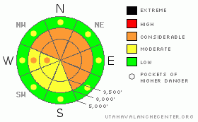
Danger Rose Tutorial
|
The avalanche danger remain CONSIDERABLE (Level 3) on steep slopes facing west through north through southeast at the mid and upper elevations. Deep dangerous slides can be triggered in isolated places on slopes approaching 35 degrees or steeper, or “attached” (adjacent) to steep slopes. Most accidents and fatalities in Utah happen during CONDIDERABLE danger – and the well developed faceted snow near the ground will trick us by remaining weak for a much longer time than we expect.
Low angle shady slopes yield good snow for riding and turning, though perhaps not the zing we’re looking for. At least skiers and boarders have the option of hitting the steeps at the resorts.
|
|
|
CURRENT CONDITIONS |

|
It’s a calm, clear morning in the mountains, with temperatures near 10 in the cold valley bottoms and in the 20’s at the mid and upper elevations. The westerly winds are very light, averaging less than 15 mph at all but a couple of the highest peaks.
Powder remains on shady mid and upper elevation slopes only, with some wind damage at the higher elevations and in open bowls. Elsewhere, its widespread sun and heat crusts that will soften with daytime heating.
|
|
|
RECENT ACTIVITY |

|
Fewer people in the backcountry yesterday on a weekday resulted in fewer observations - only one report of a very large collapse, with cracking, above the pond in Willows, BCC.
|
|
|
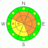
THREAT #1 |

|
| WHERE |
PROBABILITY |
SIZE |
TREND |
|
|
|
|
| |
|
|
Over the next
24 hours.
|
|
|
This is when it gets hard - the odds of triggering a slide are decreasing as the slab strengthens, but large slides are possible, just in more isolated areas. A deep, dangerous avalanche can still be triggered - from a shallow snowpack area, a place where the facets are weaker, or where the slab is thinner. With no super power x-ray vision, its hard to tell where these trigger points are.
Evaluate your terrain, check your slope angles and always think consequences – what would happen if your evaluation is wrong, and the slope does slide – sending you off a cliff, on a long ride or into a gully? Will the avalanche be 20 feet wide, or could it be 200 feet wide? Connections are very important – is the slope you are on adjacent or directly attached to a steeper slope above or to the side?
“Repeaters” are possible – some slopes that slid early in the storm cycle have filled in enough that they can be triggered again, especially where wind drifted – 2 Dogs in upper Days Fork is one example.
|
|
|
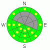
THREAT #2 |

|
| WHERE |
PROBABILITY |
SIZE |
TREND |
|
|
|
|
| |
|
|
Over the next
10 hours.
|
|
|
Clear skies and lots of sun will warm the snow on southeast through west facing slopes today, and damp sluffs will become easy to trigger on steep slopes as the day heats up. The snow will become damp on all aspects at the lower elevations. Especially avoid terrain traps like gullies, were even a sluff can pile up snow deeply as the snow warms.
|
|
|
MOUNTAIN WEATHER |

|
Another spring like day in the middle of winter – under clear, sunny skies temperatures will warm into the mid 30s at 8,000’ and the mid 20s at 10,000’. The westerly winds will be very light, less than 10 mph. A quick moving disturbance Wednesday night should produce a few inches of snow to freshen things up before the dreaded high pressure settles in for a another extended stay.
|
|
|
GENERAL ANNOUNCEMENTS |
If you trigger an avalanche in the backcountry - especially if you are adjacent to a ski area – please call the following teams to alert them to the slide and whether anyone is missing or not. Rescue teams can be exposed to significant hazard when responding to avalanches, and do not want to do so when unneeded. Thanks.
Salt Lake – Alta Central (801-742-2033)
Ogden – Snowbasin Patrol Dispatch (801-620-1017)
Provo – Sundance Patrol Dispatch (801-223-4150)
Dawn Patrol Forecast Hotline, updated by 05:30: 888-999-4019 option 8.
Twitter Updates for your mobile phone http://utahavalanchecenter.org/twitter)
Daily observations are frequently posted by 10 pm each evening.
Subscribe to the daily avalanche advisory e-mail click HERE.
UDOT canyon closures UDOT at (801) 975-4838
Wasatch Powderbird Guides does daily updates about where they'll be operating on this blog http://powderbird.blogspot.com/ .
You have the opportunity to participate in the creation of our own community avalanche advisory by submitting avalanche and snow observations. You can also call us at 801-524-5304 or 800-662-4140, or email by clicking HERE
Donate to your favorite non-profit –The Friends of the Utah Avalanche Center. The UAC depends on contributions from users like you to support our work.
We will update this forecast tomorrow morning. Thanks for calling. |
|
|
This information does not apply to developed ski areas or highways where avalanche control is normally done. This advisory is from the U.S.D.A. Forest Service, which is solely responsible for its content. This advisory describes general avalanche conditions and local variations always occur. |
|
This advisory provided by the USDA Forest Service, in partnership with:
The Friends of the Utah Avalanche Center, Utah Division of State Parks and Recreation, Utah Division of Emergency Management, Salt Lake County, Salt Lake Unified Fire Authority and the friends of the La Sal Avalanche Center. See our Sponsors Page for a complete list. |
