SPECIAL ANNOUNCEMENT |
 |
Stay connected with the UAC through Facebook and Twitter. Keep apprised of events as they happen - we often send out updates from the field. |
|
|
BOTTOM LINE
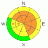
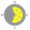
Danger by aspect and elevation on slopes approaching 35° or steeper.
(click HERE for tomorrow's danger rating)
|
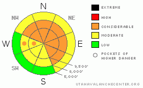
Danger Rose Tutorial
|
Very dangerous conditions exist in the backcountry.
There is a CONSIDERABLE avalanche danger for triggering deep slab avalanches and a MODERATE danger for triggering any new or old wind drifts. It’s not HIGH danger anymore, but the travel recommendations remain the same. I’d avoid the steep west to north to southeast facing slopes at the mid and upper elevations.
There is great powder for turning and riding on shady, mid and upper elevation low angle slopes. |
|
|
CURRENT CONDITIONS |

|
It’s gonna be one of those days - Bluebird, light wind, 5 star powder (for this year anyway). Truth be told, it’s also days like these where we see avalanche accidents. Discipline, self-denial – these are things we not only aspire to – it’s what keeps us alive in conditions like these. Even – perhaps especially – if you see other tracks on the slope. Or that others are getting away with it. It has applications in other parts of our lives as well.
There is still excellent riding, turning and snowshoeing in powder on low angle shady slopes at the mid and higher elevations. With yesterday’s heating and direct sun, the sunny slopes will be crusted over this morning, though softening by midday. We walked past countless steep untracked powder slopes yesterday, shook our heads, and said, ‘Ain’t it a shame.’
Today’s the 125th anniversary of the largest recorded snowflake on record – a 15” diameter monster "observed" in eastern Montana in 1887. The old timer said it about knocked over his milk-cow Bessie. |
|
|
RECENT ACTIVITY |

|
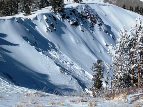
We heard of no new activity in the Provo area mountains... but in the Central Wasatch - Yesterday was quite active with avalanches releasing into both new and old snow layering. Mark Hammond found a few natural soft slabs in upper Maybird of LCC while others in upper LCC saw results of UDOT control work in the new snow in south facing terrain. Others –
· Skier triggered wind slab in Toledo Chute (Upper LCC) - a steep southeast facing line at 10,200’. It looked to be 1’ deep and 45’ wide, running maybe 700’.
· Deep slab release in the Red Cliffs along the Park City ridgeline in the Canyons backcountry pulled out 3’ deep and 100’ wide. It’s an east facing slope at 9600’ and unknown whether it was remotely triggered from above or whether a natural cornice fall triggered the slide.
· We intentionally dropped a cornice in Upper Days Fork of BCC, triggering a deep slab avalanche 3’ deep and 200’ wide. It was on a steep northerly slope at 10,100’. This was a repeater – just but one piece of the ½ mile slide Kobernik and I triggered exactly one week earlier.
· Snow safety teams at the ski areas and explosive testing by the Wasatch Powderbird Guides continue to pull out very large deep slab avalanches with explosives in steep uncompacted northerly to easterly facing terrain at highest elevations.
Propagating spooky collapses also reported in mid-elevation shady Big Cottonwood terrain…
Photo of new wind slab triggered in the Toledo Chutes...
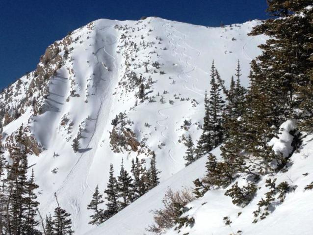
Photo below of Deep Slab in Red Cliffs (top) and Days (below)
|
|
|
THREAT #1 |

|
| WHERE |
PROBABILITY |
SIZE |
TREND |
|
|
|
|
| |
|
|
Over the next
24 hours.
|
|
|
The greatest avalanche danger remains the chance of triggering a 2 to 5 foot deep slide, breaking on the weak facets. As time goes on, these slabs become more stubborn and harder to trigger, but still have the potential to be deadly. Whereas last weekend there were 6 bullets in the chamber for Russian roulette, now there are only three. Best to keep the safety locked.
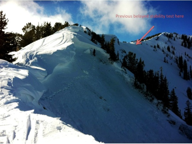
Remember that these deep slabs can break out above you and not necessarily with the first person on the slope. Ski and slope cuts are dangerous at best; non-event cornice drops should offer little assurance. As we proved yesterday (and Mark White proved a couple days ago), many of the areas that avalanched last week may still be able to slide again. |
|
|
THREAT #2 |

|
| WHERE |
PROBABILITY |
SIZE |
TREND |
|
|
|
|
| |
|
|
Over the next
24 hours.
|
|
|
Thursday night’s and last night’s stronger west to northwesterly ridgeline winds created new dense wind drifts in steep lee terrain. These will be most pronounced in steep northerly through southeasterly facing terrain along the higher elevations. They should be susceptible to slope cutting; however these may have the potential then to step down and trigger a much larger avalanche into the old early season snow. |
|
|
MOUNTAIN WEATHER |

|
Should be a nice day in the hills with clear skies, temps rising to the low 20s at 10,000’ and the low 30s at 8000’. Moderate to stronger west to northwesterly winds should persist through the day, but be confined to the highest elevations. Tomorrow looks like a carbon copy of today. A few minor storms are on tap next week – perhaps late Monday and again mid-week. |
|
|
GENERAL ANNOUNCEMENTS |
Salt Lake – Alta Central (801-742-2033)
Ogden – Snowbasin Patrol Dispatch (801-620-1017)
Provo – Sundance Patrol Dispatch (801-223-4150)
Dawn Patrol Forecast Hotline, updated by 05:30: 888-999-4019 option 8.
Daily observations are frequently posted by 10 pm each evening.
Subscribe to the daily avalanche advisory e-mail click HERE.
UDOT canyon closures UDOT at (801) 975-4838
Wasatch Powderbird Guides does daily updates about where they'll be operating on this blog http://powderbird.blogspot.com/ .
You have the opportunity to participate in the creation of our own community avalanche advisory by submitting avalanche and snow observations. You can also call us at 801-524-5304 or 800-662-4140, or email by clicking HERE
Donate to your favorite non-profit –The Friends of the Utah Avalanche Center. The UAC depends on contributions from users like you to support our work.
We will update this forecast tomorrow morning. Thanks for calling. |
|
|
This information does not apply to developed ski areas or highways where avalanche control is normally done. This advisory is from the U.S.D.A. Forest Service, which is solely responsible for its content. This advisory describes general avalanche conditions and local variations always occur. |
|
This advisory provided by the USDA Forest Service, in partnership with:
The Friends of the Utah Avalanche Center, Utah Division of State Parks and Recreation, Utah Division of Emergency Management, Salt Lake County, Salt Lake Unified Fire Authority and the friends of the La Sal Avalanche Center. See our Sponsors Page for a complete list. |
