AVALANCHE WARNING »
Dangerous avalanche conditions are occuring or are imminent.
Backcountry travel in avalanche terrain is not recommended.
|
 |
Notice:
An Avalanche Warning is in effect starting 2 pm this afternoon through Thursday for the mountains of northern and central Utah, including the Western Uintas. Heavy snow and strong winds will increase the avalanche danger to HIGH late this afternoon or tonight. Large natural and human triggered avalanches are likely during the overnight hours Wednesday and on Thursday. Backcountry travel in avalanche terrain is not recommended.
|
|
|
BOTTOM LINE
Danger by aspect and elevation on slopes approaching 35° or steeper.
(click HERE for tomorrow's danger rating)
|
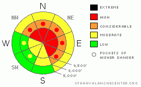
Danger Rose Tutorial
|
It will be a day of increasing avalanche danger. Once it begins to snow, this morning’s Considerable avalanche danger will rapidly rise to HIGH Danger later this afternoon or tonight. Avalanches can be triggered on wind drifted slopes first, most widespread on steep, mid and upper elevation terrain facing northwest through east. You will be able to trigger avalanches from a distance, so avoid all steep avalanche terrain and avalanche runout zones.
Low angle meadows, well away from steep slopes, offer safer terrain. Avoid terrain traps such as gullies and steep road banks.
Continued heavy snowfall, strong winds and warming temperatures Thursday will prolong the period of HIGH avalanche danger, possibly extending through the weekend.
|
|
|
CURRENT CONDITIONS |

|
Under a strong southwest flow, temperatures have warmed into the teens to mid twenties this morning. The southwesterly winds are in the 15 to 25 mph range, with gusts to 40. A few of the highest peaks are gusting into the 50s. Turning, snowshoeing and riding conditions remain rough – a thin snowpack mix of ice crusts, hard wind slabs, and punchy weak snow over rocks and logs. “Slide for life” conditions exist on some of the steep, icy slopes.
|
|
|
RECENT ACTIVITY |

|
Yesterday, the only reported avalanches were from resort explosive control work in uncompacted areas in Big Cottonwood, which released class I and class II avalanches – large enough to bury a person. A 3’ deep hard slab was remotely triggered from a ridge line in the Western Uintas.
|
|
|
THREAT #1 |

|
| WHERE |
PROBABILITY |
SIZE |
TREND |
|
|
|
|
| |
|
|
Over the next
24 hours.
|
|
|
Unusual weather – the long dry spell – creates the potential for unusual avalanche conditions – expect to see avalanches in remarkable places the next few days.
With a forecast for heavy snow and strong winds, the numerous weak layers in our snowpack will be rapidly overloaded starting late today through tonight. Wind drifted areas and slopes with a weak, unconsolidated snow pack will be the most reactive, avalanching first. This weakest snow is most widespread on steep shady low, mid and upper elevation slopes, facing northwest through east. Avalanches can be triggered remotely from a distance, and from below.
Slopes with old hard wind slabs and/or sun crusts may hold more weight before failing, resulting in deeper and more dangerous avalanches. This includes the snowpack on many of the more southerly facing slopes, which consists of ice crust and facet sandwiches.
|
|
|
MOUNTAIN WEATHER |

|
The first in a series of energetic storms will arrive by this afternoon, sweeping in from north to south. 3 to 6” of snow is possible by 5 pm today, with an additional 8 to 14” tonight. Areas favored by southwest flow will receive the higher snow amounts today, with northwest flow favored areas piling up more snow tonight. The snow will be accompanied by strong southwesterly winds today, generally in the 20 to 30 mph range, gusting in the 40s. The highest peaks may have periods with average speeds to 55 mph, with gusts to 80. The winds will switch to the northwest tonight, and remain strong.
Periods of heavy snow are possible again Thursday into Friday, with warming temperatures on Thursday and a rising rain/snow line. Storm totals by Friday could be in the 2 to 3 feet range, with 2 to 3” of water content. Additional significant snow is expected Saturday through Monday.
|
|
|
GENERAL ANNOUNCEMENTS |
If you trigger an avalanche in the backcountry - especially if you are adjacent to a ski area – please call the following teams to alert them to the slide and whether anyone is missing or not. Rescue teams can be exposed to significant hazard when responding to avalanches, and do not want to do so when unneeded. Thanks.
Salt Lake – Alta Central (801-742-2033)
Ogden – Snowbasin Patrol Dispatch (801-620-1017)
Provo – Sundance Patrol Dispatch (801-223-4150)
Dawn Patrol Forecast Hotline, updated by 05:30: 888-999-4019 option 8.
Daily observations are frequently posted by 10 pm each evening.
Subscribe to the daily avalanche advisory e-mail click HERE.
UDOT canyon closures UDOTat (801) 975-4838
Wasatch Powderbird Guides are suspending the opening of helicopter skiing operations. Once we have enough snow cover, daily updates to this bloghttp://powderbird.blogspot.com/will begin for the 2011-2012 season.
You have the opportunity to participate in the creation of our own community avalanche advisory by submittingavalanche and snow observations. You can also call us at 801-524-5304 or 800-662-4140, or email by clickingHERE
Donate to your favorite non-profit –The Friends of the Utah Avalanche Center. The UAC depends on contributions from users like you to support our work.
We will update this forecast tomorrow morning. Thanks for calling. |
|
|
This information does not apply to developed ski areas or highways where avalanche control is normally done. This advisory is from the U.S.D.A. Forest Service, which is solely responsible for its content. This advisory describes general avalanche conditions and local variations always occur. |
|
This advisory provided by the USDA Forest Service, in partnership with:
The Friends of the Utah Avalanche Center, Utah Division of State Parks and Recreation, Utah Division of Emergency Management, Salt Lake County, Salt Lake Unified Fire Authority and the friends of the La Sal Avalanche Center. See our Sponsors Page for a complete list. |
