Provo Avalanche Advisory

Forecaster: Brett Kobernik

BOTTOM LINE

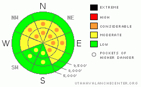
Danger by aspect and elevation on slopes approaching 35° or steeper.
(click HERE for tomorrow's danger rating)


Danger Rose Tutorial

There are pockets of a CONSIDERABLE avalanche danger in the mid and upper elevation northwest through east facing slopes. Watch for cross loaded terrain features on slopes that face any direction. Over the last week, I’ve been in steeper terrain where no wind slabs were present. This took careful analysis. I would leave that terrain alone today. Any steep slope with recent wind drifting is suspect.


CURRENT CONDITIONS

Wind. It cranked this morning from the southwest. Gusts in the 60s and 70s were common along the higher peaks. Even the mid elevation ridges saw gusts in the 40s. The dirt layer was exposed again yesterday in many spots even before the winds really picked up. Temperatures are on a downward trend in the teens along the ridges.


RECENT ACTIVITY

One small skier triggered avalanche was reported from Silver Fork on Sunday. It sounds like a recent wind slab released as it was only 4 inches deep and 60 feet wide running about 70 feet. DETAILS


THREAT #1

WHERE PROBABILITY SIZE TREND
      Over the next 24 hours.

Scattered wind slabs breaking into the persistent weak layer that consists of various sized facets remains the biggest threat to backcountry travelers today. These are going to be a little harder to sniff out as the new snow will conceal them. This morning’s wind and the expected new snow will once again only tease the avalanche danger toward CONSIDERABLE but don’t take it lightly. If you screw around in steep terrain, you could go for a ride.

I kind of categorize persistent weakness in three parts. It’s formation, it’s reactive period, and it’s stabilization. During the formation, things are relatively safe. The weak snow forms on the surface and within the snowpack to a certain degree. It doesn’t pose a whole lot of threat during this period. It’s possible that we’re done with the formation period and may be moving into the reactive period as we could add a decent slab latter this week. With how loose the snowpack is currently, we should brace for an extended reactive period. This means we could see avalanches breaking into the same weak layers for many storms to come. We won’t even speculate about the stabilization yet.


THREAT #2

WHERE PROBABILITY SIZE TREND
      Over the next 24 hours.

Along with the persistent weakness, you may find some fresh drifts that release without weak underlying snow today as well. With this type of wind event, it’s hard to judge how widespread and how sensitive things will be until you get out there so my confidence is low with this forecast.


MOUNTAIN WEATHER

Winds will slow a bit and veer more northwest after the cold front moves through. We should see a period of snow this morning with 2 to 4 inches of lower density snow containing only a few tenths of an inch of water. Temperatures will remain cool today with highs around 20 at 8000 feet. Temperatures warm slightly on Tuesday with clearing skies. An extended period of weather starting Wednesday is likely going to kick us into HIGH AVALANCHE DANGER with moderate to strong west winds, higher density snow, and the possibility of a few inches of water weight or better. Stay tuned!!


GENERAL ANNOUNCEMENTS

If you trigger an avalanche in the backcountry - especially if you are adjacent to a ski area – please call the following teams to alert them to the slide and whether anyone is missing or not. Rescue teams can be exposed to significant hazard when responding to avalanches, and do not want to do so when unneeded. Thanks.

Salt Lake – Alta Central (801-742-2033)

Ogden – Snowbasin Patrol Dispatch (801-620-1017)

Provo – Sundance Patrol Dispatch (801-223-4150)

Dawn Patrol Forecast Hotline, updated by 05:30: 888-999-4019 option 8.

Daily observations are frequently posted by 10 pm each evening.

Subscribe to the daily avalanche advisory e-mail click HERE.

UDOT canyon closures UDOTat (801) 975-4838

Wasatch Powderbird Guides are suspending the opening of helicopter skiing operations. Once we have enough snow cover, daily updates to this bloghttp://powderbird.blogspot.com/will begin for the 2011-2012 season.

You have the opportunity to participate in the creation of our own community avalanche advisory by submittingavalanche and snow observations. You can also call us at 801-524-5304 or 800-662-4140, or email by clickingHERE

Donate to your favorite non-profit –The Friends of the Utah Avalanche Center. The UAC depends on contributions from users like you to support our work.

We will update this forecast tomorrow morning. Thanks for calling.


This information does not apply to developed ski areas or highways where avalanche control is normally done.  This advisory is from the U.S.D.A. Forest Service, which is solely responsible for its content. This advisory describes general avalanche conditions and local variations always occur.


This advisory provided by the USDA Forest Service, in partnership with:

The Friends of the Utah Avalanche Center, Utah Division of State Parks and Recreation, Utah Division of Emergency Management, Salt Lake County, Salt Lake Unified Fire Authority and the friends of the La Sal Avalanche Center. See our Sponsors Page for a complete list.