SPECIAL ANNOUNCEMENT |
 |
A special avalanche advisory has been issued for the mountains of northern and central Utah. Dangerous avalanche conditions exist. Strong winds are blowing snow into drifts that can be easily triggered by people on steep slopes and from a distance. Backcountry travel in steep avalanche terrain is not recommended. |
|
|
BOTTOM LINE
Danger by aspect and elevation on slopes approaching 35° or steeper.
(click HERE for tomorrow's danger rating)
|
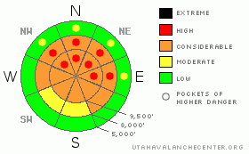
Danger Rose Tutorial
|
The avalanche danger is CONSIDERABLE with pockets of HIGH danger on steep wind drifted mid and upper elevation slopes facing northwest through east or any slope with snow pooled beneath cliffs and gullies. Avalanches one to two feet deep by 100 feet wide can be triggered. Backcountry travel on, below and adjacent to steep avalanche terrain is not recommended. Avoid all avalanche run out zones .
GO TO Terrain: Play on low angle terrain, about 30 degrees or less in steepness, like gentle meadows, well away from steep slopes. |
|
|
CURRENT CONDITIONS |

|
The front raced across northern Utah overnight, bringing howling winds and just a skiff of snow. Across the high ridges, speeds averaged in the 40s and 50s with gusts in the 80s, first from the southwest and currently from the northwest. Mid elevation terrain has speeds in the 20 to 30 mph range, with gusts in the 50s. Temperatures plummeted, dropping more than 20 degrees in a few hours, and are currently in the teens and single digits. Snow totals are all of a grand 1 to 3 inches.
|
|
|
RECENT ACTIVITY |

|
There were reports of two human triggered avalanches yesterday, both remotely triggered. One was a hard slab on a steep, heavily wind loaded, mid slope break over in Cardiff Fork, NE facing at 9700 feet. It failed on a layer of very weak facets, about 4” below the Dec 28th rain crust. The other slide was a soft slab remotely triggered by two people on an up track near the West Bowl of Silver Fork. More details and great photos of both on our Current Conditions page. |
|
|
THREAT #1 |

|
| WHERE |
PROBABILITY |
SIZE |
TREND |

|
|
|
|
| |
|
|
Over the next
12 hours.
|
|
|
The wind altered landscape has made the avalanche pattern difficult to discern. The strong winds have created pockety, very sensitive drifts, which a person will be able to trigger in many locations, failing on weak facets buried in the snow pack. Some of these drifts will be hard slabs created by the wind, others will be drifts formed where the pellet snow, or graupel, has rolled down steep gullies and cliff bands, and is pooled on lower angle slopes, also over weighting the weak facets.
It is getting very tricky out there - slides are being triggered from a distance – so do not cross below steep terrain and avoid terrain adjacent to steep slopes. Slope cuts may be ineffective because many of the drifts are mid slope, and the slides could break out above you.
The mid elevation slopes where we often head in wind events actually have some of the weakest snow, and may be where the strong winds have drifted the new snow. Cracking of the surface snow or the heart stopping sound of a collapse (or whoomph) are good indicators you’ve entered terrain where you could trigger a slide. |
|
|
THREAT #2 |

|
| WHERE |
PROBABILITY |
SIZE |
TREND |
|
|
|
|
| |
|
|
Over the next
24 hours.
|
|
|
Out of wind affected terrain, it will still be possible to trigger loose snow sluffs on steep slopes. Damp or dry, they continue to be large enough to catch and carry a person, with surprising speed, and can drag you down hill through rocks. The debris could be unexpectedly deep, especially if it piles up in a terrain trap such as a creek bottom or below a road bank. |
|
|
MOUNTAIN WEATHER |

|
Strong winds with a few light snow showers will persist through the morning, finally diminishing this afternoon. The northwesterly winds will have average speeds to 25 mph with gusts in the 40s across much of the terrain, with the highest peaks averaging 35 to 45 mph, gusting into the 70s. Temperatures will only be in the low 20s at 8,000’ and teens at 10,000’. Skies will clear tonight, and another unwelcome ridge of high pressure with clear skies and warming temperatures will haunt us through next week. |
|
|
GENERAL ANNOUNCEMENTS |
If you trigger an avalanche in the backcountry - especially if you are adjacent to a ski area – please call the following teams to alert them to the slide and whether anyone is missing or not. Rescue teams can be exposed to significant hazard when responding to avalanches, and do not want to do so when unneeded. Thanks.
Salt Lake – Alta Central (801-742-2033)
Ogden – Snowbasin Patrol Dispatch (801-620-1017)
Provo – Sundance Patrol Dispatch (801-223-4150)
Dawn Patrol Forecast Hotline, updated by 05:30: 888-999-4019 option 8.
Daily observations are frequently posted by 10 pm each evening.
Subscribe to the daily avalanche advisory e-mail click HERE.
UDOT canyon closures UDOT at (801) 975-4838
You have the opportunity to participate in the creation of our own community avalanche advisory by submitting avalanche and snow observations. You can also call us at 801-524-5304 or 800-662-4140, or email by clicking HERE
Donate to your favorite non-profit –The Friends of the Utah Avalanche Center. The UAC depends on contributions from users like you to support our work.
We will update this forecast tomorrow morning. Thanks for calling. |
|
|
This information does not apply to developed ski areas or highways where avalanche control is normally done. This advisory is from the U.S.D.A. Forest Service, which is solely responsible for its content. This advisory describes general avalanche conditions and local variations always occur. |
|
This advisory provided by the USDA Forest Service, in partnership with:
The Friends of the Utah Avalanche Center, Utah Division of State Parks and Recreation, Utah Division of Emergency Management, Salt Lake County, Salt Lake Unified Fire Authority and the friends of the La Sal Avalanche Center. See our Sponsors Page for a complete list. |
