SPECIAL ANNOUNCEMENT |
 |
Special message from our partners, the Friends of Utah Avalanche Center: This is a tense time for us. The recession is making it harder to pay for avalanche forecasting in Utah. Many of you have already donated and we deeply appreciate that. Sending in checks, donating online, buying raffle tickets at movie events, and coming to the Fall Black Diamond Party – it all helps. As 2011 comes to an end, please consider what daily avalanche information means to your knowledge of what is going on in the mountains, what elevations and aspects are likely to provide best safety and riding conditions, and your understanding of how to avoid avalanches. If this is critical to your life in the mountains, please consider an additional donation and pester your partners - are they stepping up and donating as well? With your help, we can keep this program strong and growing. To donate, go tohttp://utahavalanchecenter.org/donate Have a great holiday season and stay safe. |
|
|
BOTTOM LINE
Danger by aspect and elevation on slopes approaching 35° or steeper.
(click HERE for tomorrow's danger rating)
|
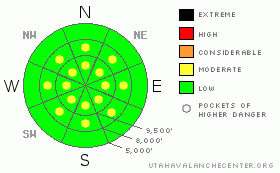
Danger Rose Tutorial
|
We have pockets of MODERATE danger of long running loose snow and shallow but sensitive soft slabs along the mid and upper elevation steep terrain. While shallow, they'll still have the potential to knock you off your feet or ride, taking you on a tumble through rocks and trees. Traumatic injury remains the significant concern unless you are carried into and buried in a terrain trap - such as a steep walled gulley or very abrupt slope transition. |
|
|
CURRENT CONDITIONS |

|
Skies are overcast this morning on the heels of what looks to be a 3-5" nice little storm. Table scraps, really, if you look at the 16" of new down in the La Sals and Abajos. They have their Avalanche Warning, we'll have areas of Moderate. Oh well. Soon enough. Winds are out of the west northwest and generally less than 15mph. Along the most exposed ridges, they've just started to blow 20mph with gusts to 30. Temps are in the low teens and single digits up high and in the low 20s down low. The new white stuff improved conditions somewhat while also thinly veiling the still protruding rocks and stumps in this vertically challenged snowpack. |
|
|
RECENT ACTIVITY |

|
Finally something across the ticker tape yesterday. Many observers reported long running sluffs (see Mark White's and Dave Kelly's pics) and some shallow soft slab development, particularly just off the ridgelines up high. One skier (thanks for the report) in mid-Little Cottonwood triggered and was briefly caught and carried in a 4-5" deep and 40' wide soft slab in steep rocky high northerly terrain. Collapsing and cracking was noted as well.
While not a surprise, the snowpack is certainly tipping its hand as to what's to come. |
|
|
THREAT #1 |

|
| WHERE |
PROBABILITY |
SIZE |
TREND |

|
|
|
|
| |
|
|
Over the next
24 hours.
|
|
|
It's debatable, but I'll call it a wind slab instead of a storm snow avalanche. Most of the shallow soft slabs reported were in high exposed terrain, just off the ridge lines. It certainly wouldn't take more than a puff of wind to move the 7-8% density smoke to create a min-slab.
We've had seemingly weeks of a soporific (sleep-inducing) snowpack. It's time to be on your game again. Choose test slopes, and perform safe ski and slope cuts to determine the reactivity of the snow. Simple shovel/tilt tests(warning - not ours/turn volume down - but good demonstration) will clearly tease out the weak interface of the new snow and the underlying facets and/or surface hoar. The weak snow lies on a variety of aspects and elevations...the load required limited to the mid and upper elevations that maybe saw a touch of wind and/or "stiffening" of the new snow. |
|
|
THREAT #2 |

|
| WHERE |
PROBABILITY |
SIZE |
TREND |
|
|
|
|
| |
|
|
Over the next
24 hours.
|
|
|
The new snow will remain sensitive to human provocation on the steepest slopes. You'll find that even in areas that only picked up a couple inches the snow will remain sensitive. If moving through steep terrain, traverse often and move from sub-ridge to sub-ridge to avoid the cascading loose snow. Remember the standard protocol - one at a time, get out of the way at the bottom, have a plan. |
|
|
MOUNTAIN WEATHER |

|
We'll have mostly cloudy skies today. Temps will be be in the upper teens up high, the low 20s down low. Winds will be northwesterly and light, though perhaps 20-25mph along the 11,000' ridge lines. The next storm splits sharply tomorrow night and we'll have more time for the snowpack to rot once again. |
|
|
GENERAL ANNOUNCEMENTS |
If you trigger an avalanche in the backcountry - especially if you are adjacent to a ski area – please call the following teams to alert them to the slide and whether anyone is missing or not. Rescue teams can be exposed to significant hazard when responding to avalanches, and do not want to do so when unneeded. Thanks.
Salt Lake – Alta Central (801-742-2033)
Ogden – Snowbasin Patrol Dispatch (801-620-1017)
Provo – Sundance Patrol Dispatch (801-223-4150)
Dawn Patrol Forecast Hotline, updated by 05:30: 888-999-4019 option 8.
Daily observations are frequentlypostedby 10 pm each evening.
Subscribe to the daily avalanche advisory e-mail clickHERE.
UDOT canyon closuresUDOTat (801) 975-4838
You have the opportunity to participate in the creation of our own community avalanche advisory by submittingavalanche and snow observations. You can also call us at 801-524-5304 or 800-662-4140, or email by clickingHERE
Donate to your favorite non-profit –The Friends of the Utah Avalanche Center.The UAC depends on contributions from users like you to support our work.
The information in this advisory is from the U.S. Forest Service, which is solely responsible for its content. This advisory describes general avalanche conditions and local variations always occur.
We will update this forecast tomorrow morning. Thanks for calling.
|
|
|
This information does not apply to developed ski areas or highways where avalanche control is normally done. This advisory is from the U.S.D.A. Forest Service, which is solely responsible for its content. This advisory describes general avalanche conditions and local variations always occur. |
|
This advisory provided by the USDA Forest Service, in partnership with:
The Friends of the Utah Avalanche Center, Utah Division of State Parks and Recreation, Utah Division of Emergency Management, Salt Lake County, Salt Lake Unified Fire Authority and the friends of the La Sal Avalanche Center. See our Sponsors Page for a complete list. |
