SPECIAL ANNOUNCEMENT |
 |
Utah Department of Transportation will likely do avalanche control Thursday morning in Provo Canyon between about 10 am and noon. Be sure to stay clear of Bridal Veil Canyon and other Provo Canyon slidepaths on Thursday.
There is no overnight closure planned for Little Cottonwood Canyon but they may do some avalanche control in the morning, depending on storm conditions.
Through a generous donation by Backcountry.com to our partners the Friends of the Utah Avalanche Center we will continue forecasting for the next couple weeks. It will be a combination of early morning weekend forecasts and mid week afternoon updates, with weekend only updates for the Logan and Uintas area mountains. Thank You!! |
|
|
BOTTOM LINE
Danger by aspect and elevation on slopes approaching 35° or steeper.
(click HERE for tomorrow's danger rating)
|
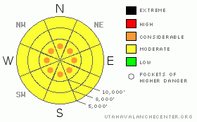
Danger Rose Tutorial
|
There is a MODERATE (Level 2) danger of wind slabs on many slopes with pockets of CONSIDERABLE (Level 3) avalanches on upper elevation ridges and wind exposed slopes. There is a MODERATE danger of avalanches in non-wind-drifted slopes and a MODERATEdanger of wet sluffs when the sun comes out today on steep, sun exposed slopes. |
|
|
CURRENT CONDITIONS |

|
4-7 inches of snow have fallen overnight in most parts of the Wasatch Range and with lake effect snow bands this morning the upper Cottonwood Canyons will likely end up just shy of a foot by the time it quits snowing this morning. The big news, though, are the winds. Usually, winds die down after the front arrives, but overnight winds have continued to blow hard from the northwest around 30 mph with higher gusts. This will likely create many areas of wind drifted snow on upper elevation, wind exposed slopes. |
|
|
RECENT ACTIVITY |

|
The only activity reported from today was in the Provo area mountains on Bunnels Peak when an intentionally-dropped cornice pulled out a wet slab in the heat of the day. Otherwise, it seems that much of the widespread wet sluffs that occurred a couple days ago have settled out.
Of note, check out the photos of a large, deep hard slab that occurred in the Provo area mountains on the 9th. This is an indicator of what is still lurking deep in the snowpack. |
|
|
THREAT #1 |

|
| WHERE |
PROBABILITY |
SIZE |
TREND |
|
|
|
|
| |
|
|
Over the next
24 hours.
|
|
|
Watch for sensitive layers within the new snow even down out of the wind drifted zones. You can easily test for this. Just quickly dig down with your hand and cut out small blocks and pull on them. You can also jump on small, test slopes. Violent storms like this commonly produce soft slab avalanches due to variable layering during the storm, but since the underlying snow is so warm and wet, it should settle out and stabilize quite quickly. This sensitive layering can occur on all aspects and elevations.
The new snow should fall on a mostly stable, but wet, underlying snowpack. We have not seen many deep releases in awhile but some of the deep layers are still lurking in some upper elevations slopes. (See Brandon Dodge's snowpit from today.) |
|
|
THREAT #2 |

|
| WHERE |
PROBABILITY |
SIZE |
TREND |

|
|
|
|
| |
|
|
Over the next
24 hours.
|
|
|
The main problem today will be wind slabs. As the snow fell, winds continued to blow hard overnight from the west and northwest 30, gusting to 45 on the exposed ridges. You will certainly find fresh wind slabs especially in upper elevation, wind exposed terrain. Much of the wind damage will likely be widespread and you may find it at mid elevations as well. Remember that wind can deposit snow 10 times more rapidly than snow falling out of the sky and they may be several feet deep in pockets of wind deposed snow. Wind slabs look smooth and rounded and often feel punchy or sound hollow. Today you should definitely stay on non-wind drifted slopes. |
|
|
THREAT #3 |

|
| WHERE |
PROBABILITY |
SIZE |
TREND |

|
|
|
|
| |
|
|
Over the next
24 hours.
|
|
|
We expect that this storm will be a quick-hitter and should clear out during the day on Thursday. The sun is very strong this time of year, so expect the new snow to quickly form damp to wet sluffs on steep, sun exposed slopes. |
|
|
MOUNTAIN WEATHER |

|
Snow should end this morning with some lingering, lake effect squalls from Farmington Canyon to the Cottonwood Canyons. Watch for strong spring sun this afternoon to warm the snow but air temperatures should remain cool--around 25 degrees-- along with continued wind. Skies should be mostly clear tonight.
Weather should remain unsettled for the next week but with no big storms in the forecast, just typical spring off-and-on showers with sun in between. |
|
|
GENERAL ANNOUNCEMENTS |
GENERAL ANNOUNCEMENTS
If you trigger an avalanche in the backcountry - especially if you are adjacent to a ski area – please call the following teams to alert them to the slide and whether anyone is missing or not. Rescue teams can be exposed to significant hazard when responding to avalanches, and do not want to do so when unneeded. Thanks.
Salt Lake – Alta Central (801-742-2033)
Ogden – Snowbasin Patrol Dispatch (801-620-1017)
Provo – Sundance Patrol Dispatch (801-223-4150)
Dawn Patrol Forecast Hotline, updated by 05:30: 888-999-4019 option 8.
Daily observations are frequently posted by 10 pm each evening.
Subscribe to the daily avalanche advisory e-mail click HERE.
UDOT canyon closures UDOT at (801) 975-4838
You have the opportunity to participate in the creation of our own community avalanche advisory by submitting avalanche and snow observations. You can also call us at 801-524-5304 or 800-662-4140, or email by clicking HERE
Donate to your favorite non-profit – The Friends of the Utah Avalanche Center. The UAC depends on contributions from users like you to support our work.
The information in this advisory is from the U.S. Forest Service, which is solely responsible for its content. This advisory describes general avalanche conditions and local variations always occur.
We will update this forecast tomorrow morning. Thanks for calling. |
|
|
This information does not apply to developed ski areas or highways where avalanche control is normally done. This advisory is from the U.S.D.A. Forest Service, which is solely responsible for its content. This advisory describes general avalanche conditions and local variations always occur. |
|
This advisory provided by the USDA Forest Service, in partnership with:
The Friends of the Utah Avalanche Center, Utah Division of State Parks and Recreation, Utah Division of Emergency Management, Salt Lake County, Salt Lake Unified Fire Authority and the friends of the La Sal Avalanche Center. See our Sponsors Page for a complete list. |
