SPECIAL ANNOUNCEMENT |
 |
Just a few Sundance ski tickets remain. If you’ve never been - you gotta go. Buy a discounted ticket, support the Utah Avalanche Center and ski/ride 16” of powder in one of Utah’s most dramatic alpine settings. Discount Lift tickets
We'd appreciate feedback!! Click on our quick survey to help us out. |
|
|
BOTTOM LINE
Danger by aspect and elevation on slopes approaching 35° or steeper.
(click HERE for tomorrow's danger rating)
|
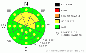
Danger Rose Tutorial
|
The avalanche danger is Level 2 MODERATE on slopes of about 35 degrees and steeper for a variety of issues:
· For fresh wind drifts in mid and upper elevation terrain, especially on slopes facing the north ½ of the compass.
· For new snow soft slabs and sluffs in areas that receive more than about 6” of new snow, especially during periods of intense, heavy snowfall
· For wet snow sluffs with afternoon sun and heating
· And finally for the very isolated chance of triggering a deep slab avalanche.
Level 2 MODERATE means human triggered avalanches are possible. Reevaluate the snow stability with changing conditions such as wind, heavy snow or heat and sun. |
|
|
CURRENT CONDITIONS |

|
The leading edge of a fast moving cold front just reached the northern Wasatch mountains around 5 am, and snow is falling. Winds are currently from the southeast, in the 15 to 25 mph range, with gusts 30 to 40. The more exposed and favored ridges and peaks are probably gusting to 50 mph. Temperatures are mild, but falling – near 30 at 8,000’ and 20 at 10,000’. Data from Mesowest not available - the U of U will be working to fix it this morning. The sun wasn’t slacking off yesterday - its heat crusted the snow on all but the upper elevation, northerly facing slopes. |
|
|
RECENT ACTIVITY |

|
Backcountry travelers were able to trigger both dry and wet loose sluffs yesterday, but no wind slabs. Resort explosive control work pried out a few class 2 hard slabs on upper elevation, wind drifted slopes in the Ogden and Salt Lake mountains.
With clear skies, observant people noticed a large, deep slide in Mineral Fork, which probably ran during the Monday/Tuesday storm. It was 3 to 10’ deep, about 500’ wide, failing just above the mid January rain crust. |
|
|
THREAT #1 |

|
| WHERE |
PROBABILITY |
SIZE |
TREND |
|
|
|
|
| |
|
|
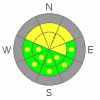
Over the next
6 hours.
|
|
|
There is the usual assortment of new snow issues to watch out for today, especially on upper elevation northwest through northeasterly facing slopes, which is just where the most consistently soft snow will be today…
· First, avoid any steep, wind drifted slopes. Brisk southeast and southerly winds will have drifted the snow at both mid and upper elevations.
· Second, a yesterday’s crop of small surface hoar may not have been destroyed on the upper elevation, northerly facing slopes. This may make any new snow slabs and drifts more sensitive than expected. Slick crusts on other aspects could allow sluffs to run further than expected.
· And finally, if you’re lucky enough to be somewhere that receives higher end snow numbers – in the 7-10” range, watch for a brief period of heightened sensitivity, especially with high precipitation rates or wind. |
|
|
THREAT #2 |

|
| WHERE |
PROBABILITY |
SIZE |
TREND |
|
|
|
|
| |
|
|
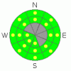
Over the next
11 hours.
|
|
|
Skies should be partly to mostly sunny by this afternoon, triggering another round of wet snow sluffs, mostly human triggered. The snow will heat ‘round the compass at the low and mid elevation, getting damp on all aspects. Once the snow heats up, avoid continuously steep slopes where these sluffs could be long runners and terrain traps where even small slides can pile debris up deeply. |
|
|
THREAT #3 |

|
| WHERE |
PROBABILITY |
SIZE |
TREND |
|
|
|
|
| |
|
|
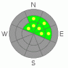
Over the next
24 hours.
|
|
|
Sure enough, the last storm did produce an isolated deep hard slab avalanche that propagated quite widely. These deep hard slabs seem to be unfortunately random in distribution. Again today, it might be possible to trigger a deep slide, mostly likely with a large cornice drop or with the weight of a new snow avalanche. Rocky, upper elevation, north through east facing, possibly above a cliff... |
|
|
MOUNTAIN WEATHER |

|
A fast moving Pacific storm system crossing the northern mountains this morning should bring 4 to 8” of snow to the higher elevations by around noon. Behind the front, the current moderate southeasterly winds will shift to the west and decrease, and 10,000’ temperatures will drop into the mid teens. Skies will become partly cloudy this afternoon, and 8,000’ temperatures warm into the mid 30’s. Two more storm systems are lined up – the next will bring another 4 to 8 inches of snow on Friday, and then another round of snow Saturday night into Sunday. |
|
|
GENERAL ANNOUNCEMENTS |
GENERAL ANNOUNCEMENTS
If you trigger an avalanche in the backcountry - especially if you are adjacent to a ski area – please call the following teams to alert them to the slide and whether anyone is missing or not. Rescue teams can be exposed to significant hazard when responding to avalanches, and do not want to do so when unneeded. Thanks.
Salt Lake – Alta Central (801-742-2033)
Ogden – Snowbasin Patrol Dispatch (801-620-1017)
Provo – Sundance Patrol Dispatch (801-223-4150)
Discount Lift tickets: Ski Utah, Backcountry.com, Alta, Deer Valley, Park City, The Canyons, Wolf Mountain, Snowbasin, Beaver Mountain, Brighton, Sundance, and Solitude have donated a limited number of tickets for sale.
Wasatch Powderbird Guides flight plan.
Dawn Patrol Forecast Hotline, updated by 05:30: 888-999-4019 option 8.
Daily observations are frequently posted by 10 pm each evening.
Subscribe to the daily avalanche advisory e-mail click HERE.
UDOT canyon closures UDOT at (801) 975-4838
You have the opportunity to participate in the creation of our own community avalanche advisory by submitting avalanche and snow observations. You can also call us at 801-524-5304 or 800-662-4140, or email by clicking HERE
Donate to your favorite non-profit – The Friends of the Utah Avalanche Center. The UAC depends on contributions from users like you to support our work.
The information in this advisory is from the U.S. Forest Service, which is solely responsible for its content. This advisory describes general avalanche conditions and local variations always occur.
We will update this forecast tomorrow morning. Thanks for calling. |
|
|
This information does not apply to developed ski areas or highways where avalanche control is normally done. This advisory is from the U.S.D.A. Forest Service, which is solely responsible for its content. This advisory describes general avalanche conditions and local variations always occur. |
|
This advisory provided by the USDA Forest Service, in partnership with:
The Friends of the Utah Avalanche Center, Utah Division of State Parks and Recreation, Utah Division of Emergency Management, Salt Lake County, Salt Lake Unified Fire Authority and the friends of the La Sal Avalanche Center. See our Sponsors Page for a complete list. |
