SPECIAL ANNOUNCEMENT |
 |
Join us for the Backcountry 101 Avalanche class on February 26 and 28. We'll do an evening lecture and a field day learning the basics about safe travel techniques, the magic of snow, rescue, and decision making in complicated conditions. In mid March, SheJumps will team up with the Friends for one final Backcountry 101 for women - details to come.
There are just a few lift tickets left - to Sundance, Wolf Mountain and the Canyons ski resorts – 100% of the sale of these donated tickets goes to support the Utah Avalanche Center. |
|
|
BOTTOM LINE
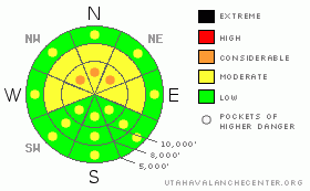
Danger by aspect and elevation on slopes approaching 35° or steeper.
(click HERE for tomorrow's danger rating)
|
Danger Rose Tutorial
|
The avalanche danger is MODERATE (Level 2) on any steep, slope with wind drifted snow, which will be most widespread along the higher ridgelines, on slopes facing northwest through northeast. Pockets of CONSIDERABLE (Level 3) danger exist on the most wind drifted slopes. These same wind drifted slopes have a MODERATE (Level 2) danger of triggering a larger, deeper slide, breaking out on a faceted weak layer. Once again, the avalanche danger is generally LOW on wind sheltered terrain. |
|
|
CURRENT CONDITIONS |

|
Overnight the flow has shifted to the south southeast, and the temperatures and winds have increased. Speeds across the higher peaks have been averaging 35 to 45 mph, with gusts to 60. Mid elevation terrain has more reasonable wind gusts mostly in the 20s and 30s. Temperatures are now in the teens at 10,000’ and the low to mid 20’s at 8,000’. Wednesday night’s snow vastly improved the turning, riding and snowshoeing conditions, though you’ll still hit the underlying crusts on some slopes. Today, search out wind sheltered slopes. |
|
|
RECENT ACTIVITY |

|
Loose sluffs running ½ to full track were the only activity reported from the backcountry yesterday, with crusts acting as a bed surface. Explosive control work at the resorts released new snow slides, class 1’s and a few class 2’s – large enough to bury a person. In the shallower snowpack of the Ogden mountains, control work slides took out 4 to 8” of older snow to run on the January rain crust. |
|
|
THREAT #1 |

|
| WHERE |
PROBABILITY |
SIZE |
TREND |

|
|
|
|
| |
|
|
Over the next
12 hours.
|
|
|
The wind slabs that I thought would be out there yesterday will probably be there today instead. The moderate to strong southeasterly winds will be forming denser drifts on northwest, north and northeasterly facing slopes along the higher ridgelines. The drifts will increase in depth, width and sensitivity as long as the winds keep blowing. Also be alert and avoid any drifts that form mid slope in the windiest drainages, cross loading along gully walls and mid slope breakovers. Careful cornice kicking is a good place to start, but won’t be as effective or safe once the wind drifts get large or form denser hard slabs. |
|
|
THREAT #2 |

|
| WHERE |
PROBABILITY |
SIZE |
TREND |

|
|
|
|
| |
|
|
Over the next
12 hours.
|
|
|
Today’s winds will be loading the north half of the compass, aspects where there are some remaining persistent weak layers, which vary widely over short distances. There may be isolated places on more wind loaded slopes where a slide could step down into a deeper weak layer, near the crusts. As usual, shallower snow pack areas are weaker and potential trigger points. |
|
|
THREAT #3 |

|
| WHERE |
PROBABILITY |
SIZE |
TREND |

|
|
|
|
| |
|
|
Over the next
10 hours.
|
|
|
The combination of partly cloudy skies and the wind should help keep any wet avalanche activity to a minimum. But if the clouds thin and the snow heats up where you are, wet loose sluffs running on the crust beneath may become easy to trigger on steep, sunny slopes. |
|
|
MOUNTAIN WEATHER |

|
Northern Utah will be under a southerly flow through the weekend, with mostly cloudy skies and periods of light snow. Today, skies will be partly to mostly cloudy and temperatures will warm into the low 30’s at 8,000’ and to near 20 at 10,000’. The southeasterly winds will remain brisk across the high elevation terrain, averaging 30 to 40 mph, with gusts in the 50’s to 60’s at times. Mid elevation terrain will average less than 20 mph, with gusts to 30. The main energy of the Pacific trough moving inland this weekend will be to the south of us, but the northern mountains will get periods of snow, with the best chance for accumulations Saturday night into Sunday. The mid week storm continues to look more organized, and more favorable for snow in the northern mountains. |
|
|
GENERAL ANNOUNCEMENTS |
If you trigger an avalanche in the backcountry - especially if you are adjacent to a ski area – please call the following teams to alert them to the slide and whether anyone is missing or not. Rescue teams can be exposed to significant hazard when responding to avalanches, and do not want to do so when unneeded. Thanks.
Salt Lake – Alta Central (801-742-2033)
Ogden – Snowbasin Patrol Dispatch (801-620-1017)
Provo – Sundance Patrol Dispatch (801-223-4150)
Discount Lift tickets: Ski Utah, Backcountry.com, Alta, Deer Valley, Park City, The Canyons, Wolf Mountain, Snowbasin, Beaver Mountain, Brighton, Sundance, and Solitude have donated a limited number of tickets for sale.
Wasatch Powderbird Guides flight plan.
Dawn Patrol Forecast Hotline, updated by 05:30: 888-999-4019 option 8.
Daily observations are frequently posted by 10 pm each evening.
Subscribe to the daily avalanche advisory e-mail click HERE.
UDOT canyon closures UDOT at (801) 975-4838
You have the opportunity to participate in the creation of our own community avalanche advisory by submitting avalanche and snow observations. You can also call us at 801-524-5304 or 800-662-4140, or email by clicking HERE
Donate to your favorite non-profit – The Friends of the Utah Avalanche Center. The UAC depends on contributions from users like you to support our work.
The information in this advisory is from the U.S. Forest Service, which is solely responsible for its content. This advisory describes general avalanche conditions and local variations always occur.
We will update this forecast tomorrow morning. Thanks for calling. |
|
|
This information does not apply to developed ski areas or highways where avalanche control is normally done. This advisory is from the U.S.D.A. Forest Service, which is solely responsible for its content. This advisory describes general avalanche conditions and local variations always occur. |
|
This advisory provided by the USDA Forest Service, in partnership with:
The Friends of the Utah Avalanche Center, Utah Division of State Parks and Recreation, Utah Division of Emergency Management, Salt Lake County, Salt Lake Unified Fire Authority and the friends of the La Sal Avalanche Center. See our Sponsors Page for a complete list. |
