SPECIAL ANNOUNCEMENT |
 |
The Friends of the Utah Avalanche Center is auctioning off a pair of 176 cm Black Diamond Drift skis with custom Utah Avalanche Center graphics as a fundraiser. Go to Ebay and search for item320647801970 for photos and to bid.
There are just a few lift tickets left - to Sundance, Wolf Mountain and Brianhead ski resorts – 100% of the sale of these donated tickets goes to support the Utah Avalanche Center. |
|
|
BOTTOM LINE
Danger by aspect and elevation on slopes approaching 35° or steeper.
(click HERE for tomorrow's danger rating)
|
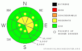
Danger Rose Tutorial
|
The avalanche danger is Level 2 (Moderate) on any slope approaching 35 degrees or steeper with recent deposits of wind drifted snow. There are pockets of Level 2 (Moderate) danger for triggering a deeper, hard slab. These are difficult to trigger but they will be quite large and dangerous if you do. |
|
|
CURRENT CONDITIONS |

|
Two inches of light snow fell overnight without much wind. Ridge top temperatures have dropped from the mid 20's yesterday to 15 degrees and will plunge to around -15 on Tuesday.
Snow surface conditions--you name it, we got it. Wind damage at high and mid elevations, sun crusts on sun exposed, slide-for-life hard rain crust where the wind has stripped away the foot of light snow above it, and yes, you can still find some scraps of soft, settled, faceted snow on wind and sun sheltered, mid elevation slopes if you can find someplace that is not completely tracked out. As one observer said, "We're ready to shake up the Etch-a-Sketch." |
|
|
RECENT ACTIVITY |

|
The only activity we heard about yesterday was a skier-triggered, wind slab at around 9,000' on a breakover in White Pine in the Salt Lake area mountains. It was a small slab and the skier skied off of it. Otherwise, most slopes have been completely tracked out without incident this weekend.
For a great way to look at the history of recent avalanches in northern Utah, go to the Table View. |
|
|
THREAT #1 |

|
| WHERE |
PROBABILITY |
SIZE |
TREND |

|
|
|
|
| |
|
|
Over the next
24 hours.
|
|
|
The wind blew quite hard yesterday from the southwest at upper and mid elevations, creating fairly widespread, shallow, wind slabs, which were both hard and soft. Where the wind deposited slabs on top of the pre-existing, fine-grained, faceted snow, they cracked easily and sometimes produced shallow, pockety slabs. So as always, avoid steep slopes with recent wind deposits.
The only good thing about the wind is that it destroyed much of the surface hoar that formed on the snow surface these past few days, at least at upper and many mid elevation, wind exposed areas. But the surface hoar remains on lower elevation, wind sheltered slopes.
Click HERE for a generalized snow profile. |
|
|
THREAT #2 |

|
| WHERE |
PROBABILITY |
SIZE |
TREND |
|
|
|
|
| |
|
|
Over the next
24 hours.
|
|
|
Our old friend, the buried surface hoar, is still down there under the rain crust and our snowpit tests continue to show that it's stubborn to trigger but it can still propagate a fracture. This is the classic "Scary Moderate" situation, in other words, low probility - high consequences. Hard to trigger but if you do, it will produce a large, dangerous avalanche. We have not seen any of these in the past few days but the weight of wind slabs may reactivate it in localized areas. As for me, I want to die as an old man, so I choose to avoid steep slopes above 9,500'. But then again, obviously, hoards of people have not avoided those slopes this past weekend and they all came back alive. Your call. |
|
|
MOUNTAIN WEATHER |

|
We will continue to have light snow showers today with perhaps another couple inches. Then, as much colder air arrives on Tuesday, we will see a couple more inches of light snow. Storm totals will probably be disappointing--perhaps 4 inches. Today, ridge top winds will be light to moderate from the northwest with temperatures around 10 degrees. On Tuesday, temperatures will plummet to around -15 with continued moderate winds from the north, turning northeast.
The extended forecast calls for temperatures to rebound by Thursday. Unfortunately, we still don't see any significant snow in the forecast with the exception of a couple of weak disturbances around the weekend. |
|
|
GENERAL ANNOUNCEMENTS |
If you trigger an avalanche in the backcountry - especially if you are adjacent to a ski area – please call the following teams to alert them to the slide and whether anyone is missing or not. Rescue teams can be exposed to significant hazard when responding to avalanches, and do not want to do so when unneeded. Thanks.
Salt Lake – Alta Central (801-742-2033)
Ogden – Snowbasin Patrol Dispatch (801-620-1017)
Provo – Sundance Patrol Dispatch (801-223-4150)
Discount Lift tickets: Ski Utah, Backcountry.com, Alta, Deer Valley, Park City, The Canyons, Wolf Mountain, Snowbasin, Beaver Mountain, Brighton, Sundance, and Solitude have donated a limited number of tickets for sale.
Wasatch Powderbird Guides flight plan.
Dawn Patrol Forecast Hotline, updated by 05:30: 888-999-4019 option 8. Daily observations are frequently posted by 10 pm each evening.
Subscribe to the daily avalanche advisory e-mail click HERE.
UDOT canyon closures UDOT at (801) 975-4838
You have the opportunity to participate in the creation of our own community avalanche advisory by submitting avalanche and snow observations. You can also call us at 801-524-5304 or 800-662-4140, or email by clicking HERE
Donate to your favorite non-profit – The Friends of the Utah Avalanche Center. The UAC depends on contributions from users like you to support our work.
The information in this advisory is from the U.S. Forest Service, which is solely responsible for its content. This advisory describes general avalanche conditions and local variations always occur. We will update this forecast tomorrow morning.
Thanks for calling. |
|
|
This information does not apply to developed ski areas or highways where avalanche control is normally done. This advisory is from the U.S.D.A. Forest Service, which is solely responsible for its content. This advisory describes general avalanche conditions and local variations always occur. |
|
This advisory provided by the USDA Forest Service, in partnership with:
The Friends of the Utah Avalanche Center, Utah Division of State Parks and Recreation, Utah Division of Emergency Management, Salt Lake County, Salt Lake Unified Fire Authority and the friends of the La Sal Avalanche Center. See our Sponsors Page for a complete list. |
