AVALANCHE WATCH »
The risk of an avalanche is expected to increase significantly
but the timing and location are still uncertain. Stay tuned for updates.
|
 |
Notice: An Avalanche Watch has been issued for the mountains of northern Utah. Strong winds and heavy snow fall will create an increasing avalanche danger today through Thursday. Both human triggered and natural avalanches are possible. Backcountry travelers need excellent terrain and snowpack evaluation skills and should avoid steep slopes and avalanche runout zones. |
|
|
BOTTOM LINE
Danger by aspect and elevation on slopes approaching 35° or steeper.
(click HERE for tomorrow's danger rating)
|
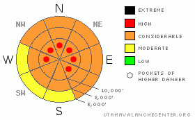
Danger Rose Tutorial
|
With continuing strong winds and heavy snowfall, the avalanche danger will rapidly rise to LEVEL 3 (CONSIDERABLE) on all steep, wind drifted slopes. During periods of intense snowfall and strong winds, such as around frontal passage early this afternoon, the danger could spike to LEVEL 4 (HIGH), with natural avalanches possible. On steep, wind sheltered slopes; the avalanche danger will rise more gradually.
Backcountry travelers should choose tours that emphasize travel on wind sheltered slopes less steep than 35 degrees, avoid travel below steep slopes, and have safe exits planned for the end of the day. Be ready to adjust your travel plans to the increasing avalanche danger, especially during periods of intense snowfall and strong winds. |
|
|
CURRENT CONDITIONS |

|
Most people were ready for a fresh blanket of new powder for the New Year…and here it comes. Areas favored by southwest flow are stacking up the new snow fast this morning, with 8 to 10” of dense snow as of 6 am, containing over an inch of water weight. 2 to 6” have fallen elsewhere. The southerly winds picked up before midnight, and are downright brutal, with many stations averaging 25 to 40 mph, gusting to 60, and the highest peaks hitting gusts of 80 mph. Temperatures are near 20 at 10,000’. |
|
|
RECENT ACTIVITY |

|
No avalanche activity was reported from the backcountry yesterday, but heavy snowfall and strong winds spell a very different story today. |
|
|
THREAT #1 |

|
| WHERE |
PROBABILITY |
SIZE |
TREND |

|
|
|
|
| |
|
|
Over the next
24 hours.
|
|
|
There is going to be a lot of blowing and drifting snow out there today, with sensitive drifts becoming more widespread and deeper all day long. The snow is drifted along the ridge lines, but drifts will also be common well off the ridge lines due to the strong winds. Watch for drifts cross loaded at the top of mid slope break overs and along gully walls. Wind drifts will be most widespread this morning on northerly facing slopes, with the focus shifting to more northeast through southeast as the winds shift this afternoon and tonight. |
|
|
THREAT #2 |

|
| WHERE |
PROBABILITY |
SIZE |
TREND |

|
|
|
|
| |
|
|
Over the next
24 hours.
|
|
|
The new snow is landing on a wide mix of old snow surfaces – from stout wind and sun crusts, to weak surface snow on mid and upper elevation northwest through southeasterly facing slopes. The most dangerous slopes will be those with shallowly buried surface hoar, near surface facets and weak crusts, which seem to be most wide spread in the Ogden area mountains and north. Watch for buried surface hoar off the windswept ridgelines, on wind sheltered slopes and near creek and valley bottoms. The avalanche danger will increase more gradually on steep, wind sheltered slopes, and will peak anytime the snow fall rates increase where you are, especially when they reach rates of 2 to 3”/hour. |
|
|
MOUNTAIN WEATHER |

|
A moist flow will bring heavy snow to areas favored by southwest flow this morning, ahead of a strong cold front which should reach the Salt Lake area mountains early this afternoon. 12 to 18” of new snow is possible by evening in many areas of the northern Utah mountains favored by southwest flow, with other areas receiving 6 to 12”. Late this afternoon through tonight, favored areas will be reversed to that of northwest flow. General new snow totals of two feet are expected by Thursday morning, and the snow should be “right side up” for a change. Winds will remain strong all day, first from a southerly direction, then shifting to the northwest this afternoon. 25 to 35 mph averages will be common, with the highest terrain averaging closer to 40 mph, with gusts in the 60’s and 70’s. Temperatures will be in the upper teens to near 30. Snowfall will linger through Thursday and possibly into Friday, with mountain temperatures dropping to near zero. |
|
|
GENERAL ANNOUNCEMENTS |
If you trigger an avalanche in the backcountry - especially if you are adjacent to a ski area – please call the following teams to alert them to the slide and whether anyone is missing or not. Rescue teams can be exposed to significant hazard when responding to avalanches, and do not want to do so when unneeded. Thanks.
Salt Lake – Alta Central (801-742-2033)
Ogden – Snowbasin Patrol Dispatch (801-620-1017)
Provo – Sundance Patrol Dispatch (801-223-4150)
Discount Lift tickets: Ski Utah, Backcountry.com, Alta, Deer Valley, Park City, The Canyons, Wolf Mountain, Snowbasin, Beaver Mountain, Brighton, Sundance, and Solitude have donated a limited number of tickets for sale.
Wasatch Powderbird Guides flight plan.
Dawn Patrol Forecast Hotline, updated by 05:30: 888-999-4019 option 8.
Daily observations are frequently posted by 10 pm each evening.
Subscribe to the daily avalanche advisory e-mail click HERE.
UDOT canyon closures UDOT at (801) 975-4838
You have the opportunity to participate in the creation of our own community avalanche advisory by submitting avalanche and snow observations. You can also call us at 801-524-5304 or 800-662-4140, or email to uac@utahavalanchecenter.org
Donate to your favorite non-profit – The Friends of the Utah Avalanche Center. The UAC depends on contributions from users like you to support our work. |
|
|
This information does not apply to developed ski areas or highways where avalanche control is normally done. This advisory is from the U.S.D.A. Forest Service, which is solely responsible for its content. This advisory describes general avalanche conditions and local variations always occur. |
|
This advisory provided by the USDA Forest Service, in partnership with:
The Friends of the Utah Avalanche Center, Utah Division of State Parks and Recreation, Utah Division of Emergency Management, Salt Lake County, Salt Lake Unified Fire Authority and the friends of the La Sal Avalanche Center. See our Sponsors Page for a complete list. |
