SPECIAL ANNOUNCEMENT |
 |
There is still time to go to the KBYG Snowmobile Talk and Avy Beacon session today at Big Pine Sports, Fairview, Utah. Pancake Breakfast from 10am - Noon. Raffles, great deals and a snowmobile specific avalanche awareness talk at 1pm. Beacon Session to follow talk.
The Friends of the Utah Avalanche Center will be teaching 1 evening/1 field day introductory and advanced avalanche classes this winter beginning Thursday, Dec 16th. There is also a Free Women’s Beacon Clinic on Monday, Dec 13th, meeting at 9 am at the Albion Grill. Details are on our Education Page.
Snowbird Ski and Summer Resort and the Utah Avalanche Center (UAC) are once again partnering to offer the second annual Freeride Avalanche Summit, Dec. 16-17. The two-day clinic is targeted towards advanced and expert skiers and riders who want practical and professional instruction on avalanche awareness, safety and rescue. For more info go to Snowbird's web site. |
|
|
BOTTOM LINE
Danger by aspect and elevation on slopes approaching 35° or steeper.
(click HERE for tomorrow's danger rating)
|
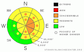
Danger Rose Tutorial
|
Avalanche danger is Level 3 (Considerable) on any slope approaching 35 degrees or steeper with recent deposits of wind drifted snow. The most likely place to trigger the 1 to 2 foot deep wind drifts will be on upper elevation slopes facing northeast, east and southeast, with drifts more scattered at the mid elevations. Avoid any steep slope with recent wind drifts. Out of wind affected terrain and on slopes less steep than about 35 degrees, the avalanche danger is generally a Level 1 (Low).
The avalanche danger will increase once again tonight, due to another period of strong northwesterly winds. |
|
|
CURRENT CONDITIONS |

|
Storm totals are generally in the 6 to 10” range in the Ogden and Provo area mountains, with the upper Cottonwood Canyon and Park City ridgelines pulling ahead with about a foot of new snow. Densities have decrease from about 12% yesterday to 8% overnight. (The higher end water equivalents are in parts of the Park City and Ogden area mountains and upper Cottonwoods with an inch or more of water.) Temperatures are in the upper teens to mid 20’s this morning, and thankfully the westerly winds have toned it down from yesterday’s brutal speeds. All but the few highest peaks are averaging less than 15 mph, with gusts below 30 mph.
With help from the wind, the graupel laden snow efficiently filled in the old tracks yesterday, and snowshoeing, riding and snowmobiling conditions should be excellent today. Low angle slopes are fast. |
|
|
RECENT ACTIVITY |

|
Avalanche activity was in wind drifted terrain yesterday, where soft wind drifts 4 to12 inches deep by 20 to 100 feet wide were easily triggered by people. The sloppy, low elevation wet snow should be cooling. |
|
|
THREAT #1 |

|
| WHERE |
PROBABILITY |
SIZE |
TREND |
|
|
|
|
| |
|
|
Over the next
12 hours.
|
|
|
With another 12 hours of wind and double the snow, the wind drifts are much more widespread and deeper this morning than when we all left the backcountry yesterday. In wind affected terrain, the drifts and cornices will commonly be 1 to 2 feet deep, with a tricky mix of both sensitive and more stubborn. Most likely place to trigger one of these dangerous wind slabs will be on a steep, northeast through southeasterly facing slope along the higher ridges. But the strong winds will have also loaded snow well off the ridgelines, along gully walls and mid slope break overs. While winds have decreased in most locations, loading is still occurring across the highest ridges and peaks, where averages are still 35 to 45 mph, with gusts in the 60’s, so avoid travel both on and below these high elevation, wind drifted slopes.
Advanced users – it might be a good day to carry a rope or cutting cord, to drop cornices without having to get out onto them. But make sure there is no one beneath you!! |
|
|
THREAT #2 |

|
| WHERE |
PROBABILITY |
SIZE |
TREND |

|
|
|
|
| |
|
|
Over the next
12 hours.
|
|
|
Out of the wind affected terrain, it will be possible to trigger new snow sluffs and soft slabs on steep slopes. Test your theories on small test slopes, not the big ones, to see if there are any lingering weaknesses within the newest snow.
Don’t completely forget about the rest of the snowpack. In many areas, including the mid elevations, the shallow snow pack is still less than about 3 feet. Here, the buried weak layers involving facets are more than just a foot note – they can be a significant part of the snowpack. While less than an inch of water has probably not overloaded these weak layers yet, I’m still checking them out where ever I go. |
|
|
MOUNTAIN WEATHER |

|
Today is the perfect break to get out and play, with partly cloudy skies and decreasing westerly winds. Temperatures will warm to near 30 at 8,000’ and into the low 20’s at 10,000’, and winds should be in the 10 to 15 mph range, except across the highest terrain.
Increasing clouds again late this afternoon, due to an approaching warm front. The northwesterly winds are forecast to become obnoxious at the higher elevations again tonight, with 30 to 40 mph averages and gusts in the 50’s common, with gusts to 85 possible over the highest terrain. A few more inches of snow is likely. High pressure Sunday afternoon through Monday will bring very warm and dry conditions. |
|
|
GENERAL ANNOUNCEMENTS |
If you trigger an avalanche in the backcountry - especially if you are adjacent to a ski area – please call the following teams to alert them to the slide and whether anyone is missing or not. Rescue teams can be exposed to significant hazard when responding to avalanches, and do not want to do so when unneeded. Thanks.
Salt Lake – Alta Central (801-742-2033)
Ogden – Snowbasin Patrol Dispatch (801-620-1017)
Provo – Sundance Patrol Dispatch (801-223-4150)
Discount Lift tickets: Ski Utah, Backcountry.com, Alta, Deer Valley, Park City, The Canyons, Wolf Mountain, Snowbasin, Beaver Mountain, Brighton, Sundance, and Solitude have donated a limited number of tickets for sale at discounted prices.
Wasatch Powderbird Guides flight plan.
Dawn Patrol Forecast Hotline, updated by 05:30: 888-999-4019 option 8.
Daily observations are frequently posted by 10 pm each evening.
Subscribe to the daily avalanche advisory e-mail click HERE.
UDOT canyon closures UDOT at (801) 975-4838
You have the opportunity to participate in the creation of our own community avalanche advisory by submitting avalanche and snow observations. You can also call us at 801-524-5304 or 800-662-4140, or email to uac@utahavalanchecenter.org
Donate to your favorite non-profit – The Friends of the Utah Avalanche Center. The UAC depends on contributions from users like you to support our work.
The information in this advisory is from the U.S. Forest Service, which is solely responsible for its content. This advisory describes general avalanche conditions and local variations always occur.
We will update this forecast tomorrow morning. Thanks for calling. |
|
|
This information does not apply to developed ski areas or highways where avalanche control is normally done. This advisory is from the U.S.D.A. Forest Service, which is solely responsible for its content. This advisory describes general avalanche conditions and local variations always occur. |
|
This advisory provided by the USDA Forest Service, in partnership with:
The Friends of the Utah Avalanche Center, Utah Division of State Parks and Recreation, Utah Division of Emergency Management, Salt Lake County, Salt Lake Unified Fire Authority and the friends of the La Sal Avalanche Center. See our Sponsors Page for a complete list. |
