SPECIAL ANNOUNCEMENT |
 |
Celebrating the onset of winter, first snowfalls and the opening of Utah's ski resorts, executive chef Nathan Powers of the award-winning Bambara, a downtown Kimpton restaurant, has created "Snowstorm" specials to benefit the Utah Avalanche Center. From Monday, November 1 through Friday, November 12, a dollar from each “Snowstorm” special (only $13) will be donated to the UAC. For more info, find them online. |
|
|
BOTTOM LINE
Danger by aspect and elevation on slopes approaching 35° or steeper.
(click HERE for tomorrow's danger rating)
|
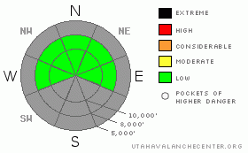
Danger Rose Tutorial
|
The avalanche danger is generally LOW. Minor sluffing is likely in the overnight low density fluff. |
|
|
CURRENT CONDITIONS |

|
Overcast skies and flurries continue to envelop most of the range in the aftermath of yesterday’s tailor-made early season storm. We have another 3-5” overnight, and with some extrapolation, storm totals are adding up to about 14-17” in the upper Cottonwoods, 6-8” in the Park City and Ogden mountains, with perhaps 8-10” in the high elevations above Provo. It was what you’d call ‘thick around the ankles’ - densities averaged perhaps 16% yesterday to provide another good foundation to our early season snowpack. Riding conditions were good. You’ll find that today as well. Mountain temps are in the mid teens; winds are generally less than 15mph from the northwest. |
|
|
RECENT ACTIVITY |

|
Not much to discuss in the way of avalanches. I saw no signs of instability yesterday and received no reports from the backcountry. Imagine having the whole place to yourself. Don't forget to check for more details under Current Conditions in the bar up and to the left, or click here. |
|
|
THREAT #1 |

|
| WHERE |
PROBABILITY |
SIZE |
TREND |
|
|
|
|
| |
|
|
Over the next
24 hours.
|
|
|
The warm snow bonded well to the old snow surfaces, and fell with little to no wind. ‘Weak’ interfaces were found a few inches within the storm snow on a quick-to-heal graupel layer and at the old boundary on the strictly shady slopes above about 9800’. The warm temperatures from the weekend helped to strengthen the weaker surface snow in the high northerly terrain and I feel that yesterday’s warm snow will only further insulate and heal these faceted grains. |
|
|
THREAT #2 |

|
| WHERE |
PROBABILITY |
SIZE |
TREND |

|
| No probability identified. |
|
|
|
|
|
Still, the icon says ‘Normal Caution’. Practice with your transceiver. Jump on test slopes. Put only one person on the slope at a time. Get out of the way at the bottom. Make a plan. Communicate.
Learn how you make decisions. This may be the silver bullet. The author Laurence Gonzales, in Deep Survival, writes
“that instant physical feedback, those feelings that are located through emotional bookmarks, will more or less force a decision unless checked by a higher consciousness. Using this system, you can make decisions very quickly and be unable to explain your choice afterward. Gonzales has looked into numerous incidents, including avalanche accidents and fatalities to explain why people would go into avalanche terrain even though they knew the danger was significant. So later, when people ask ‘What were they thinking?’, the answer is, ‘They weren’t. The whole point of the system (emotional bookmarks) is that you don’t have to think.” |
|
|
MOUNTAIN WEATHER |

|
We’ll have continued off and on flurries through the morning and mostly cloudy skies by the afternoon. Temperatures should remain in the teens with generally light northwest-backing-to westerly winds. Another storm system arrives Wednesday evening though should provide another few inches of snow, and, depending on which model you put your money on, another brush-by over the weekend. |
|
|
GENERAL ANNOUNCEMENTS |
If you’re getting out and see anything we should know about please let us know. You can leave a message at (801) 524-5304 or 1-800-662-4140, or email us at uac@avalanche.org. (Fax 801-524-6301). Better yet, send us an ob with pics on the Submit an Observation link on the home page.
The information in this advisory is from the U.S. Forest Service, which is solely responsible for its content. This advisory describes general avalanche conditions and local variations always occur.
I will update this advisory by 7:30 Wednesday morning. |
|
|
This information does not apply to developed ski areas or highways where avalanche control is normally done. This advisory is from the U.S.D.A. Forest Service, which is solely responsible for its content. This advisory describes general avalanche conditions and local variations always occur. |
|
This advisory provided by the USDA Forest Service, in partnership with:
The Friends of the Utah Avalanche Center, Utah Division of State Parks and Recreation, Utah Division of Emergency Management, Salt Lake County, Salt Lake Unified Fire Authority and the friends of the La Sal Avalanche Center. See our Sponsors Page for a complete list. |
