Provo Avalanche Advisory

Forecaster: Drew Hardesty

SPECIAL ANNOUNCEMENT

There are a few spots left in the Friends 3-day Brighton Avalanche 1 class, February 13 through 15. It’s a killer deal for 16 to 24 year olds, only $150. Loaner beacons, shovels and probes for the class are available. Sign-ups at Black Diamond retail.


BOTTOM LINE

Danger by aspect and elevation on slopes approaching 35° or steeper.
(click HERE for tomorrow's danger rating)


Danger Rose Tutorial

An overall MODERATE danger exists in the Wasatch. Pockets of CONSIDERABLE danger dot the landscape on the steeper northwest through north through northeast facing slopes at the mid and upper elevations. Clearly, it’s still possible to trigger dangerous and persistent deep hard slabs 2-4’ deep. Death or serious injury is likely.

Ogden area mountains:

A TRICKY MODERATE danger exists at the mid and low elevations with the lingering surface hoar from late January. My own party triggered a loud collapse yesterday on the 15mm feathers while approaching an older natural.


CURRENT CONDITIONS

Skies are clear, winds are light, and temps are in the single digits to low teens. Riding conditions are excellent in the sheltered terrain and sun crusted on the east to south to westerly facing slopes.


RECENT ACTIVITY

· per-sis-tent, adj. 1. lasting or enduring. 2. existing for a long or longer than usual time. 3. continuing without change in function or structure.

A rough day in the backcountry yesterday. Multiple dangerous slides triggered with many close calls, including one that required a helicopter evacuation due to reported extensively fractured legs. We’ll start with that one.

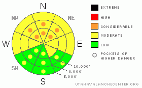
· Hats off to members of the SL county SAR, WBR, AirMED, and others for the rescue. An experienced skier triggered a 2-4’ deep 600’ wide hard slab on a steep rocky slope half-way down Wilson Peak northwest into Alexander Basin yesterday. He hit a tree sustaining numerous severe injuries, but kept him from going for the full 1000’ ride and potential burial.

· In the next drainage to the west, a very experienced backcountry skier triggered a deep slab a few turns down the main face of Gobbler’s Knob. It was on a steep northwest facing slope at 9500’, pulling out 2-4’ deep and 400’ wide, running over 2000’. He was able to grab a tree to slow down, reportedly dislocated his shoulder while trying to arrest on the bed surface and washed 1500’ down the slope. He was able to get out on his own.

· Gobbler’s was the scene of another avalanche. Another very experienced party unintentionally triggered a 2-3’ deep and 75’ wide hard slab on a steep northwest facing slope at 9300’. It was the third skier on the run, taking out previously laid tracks.

· Witnesses standing at the top of Main Days watched a lone skier trigger a slab on a hanging snowfield above the cliffband of what is called Jaws, a steep couloir in Upper Days. It looks to be 1-2’ deep and perhaps 50’ wide with debris spilling over the cliffs below.

· In Argenta, a notorious slide path above BCC, a snow-shoer collapsed a piece of snow at 9700’. It cracked 10’ wide, likely provoking the facets buried a few feet below.

· In the Bountiful Peak area, Bruce’s party triggered a small soft slab on surface hoar a foot deep and 20’ wide on a 29 degree slope. It ran an estimated 60’ on the gentle north facing slope at 8000’.


THREAT #1

WHERE PROBABILITY SIZE TREND
      Over the next 24 hours.

The most dangerous snow pack issue is the loose, weak snow is found near the base of the pack. Both the slab above and the weak layer are slowly strengthening, but there are still places where one can trigger a 2 to 4’ deep slide near the ground. The most suspect slopes face northwest through east at the mid and upper elevations. A slide would most likely be triggered in a shallow, rocky spot, such as a steep break over, and then propagate.

Very, very experienced people are being fooled by this notoriously tricky snowpack. Professionals. People with 30 years in the business. Terrain is your friend. The riding is quite good on the gentler slopes. Ensure that the slope you’re on is not attached to or under a steeper avalanche path nearby. Unsure? Get educated – take an avalanche class – and come back another time. This problem is not going away anytime soon.


THREAT #3

WHERE PROBABILITY SIZE TREND
      Over the next 8 hours.

Watch for some dampening of the snow surface with daytime heating. Expect some human triggered sluffing.


MOUNTAIN WEATHER

We’ll have mostly sunny skies, light northeasterly winds, and temps in the low teens at 10,000’ and mid-twenties at 8000’. Another storm dives south of us by mid-week.


GENERAL ANNOUNCEMENTS

Please contact Alta Central (801-742-2033) if you trigger a large avalanche in the backcountry, especially if you are adjacent to a ski area, to alert them to the slide and whether anyone is missing or not. Rescue teams can be exposed to significant hazard when responding to avalanches, and do not want to do so when unneeded. Thanks.

Discount Lift tickets: Ski Utah, Backcountry.com, Alta, Deer Valley, Park City, The Canyons, Wolf Mountain, Snowbasin, Beaver Mountain, Brighton, Sundance, and Solitude have donated a limited number of tickets for sale at discounted prices.

Wasatch Powderbird Guides flight plan.

Dawn Patrol Forecast Hotline, updated by 05:30:888-999-4019 option 8.

Daily observations are frequently posted by 10 pm each evening.

Free UAC iPhone app from Canyon Sports.

Subscribe to the daily avalanche advisory e-mail click HERE.

UDOT canyon closures UDOT at (801) 975-4838

We appreciate all your avalanche and snow observations. You can also call us at 801-524-5304 or 800-662-4140, or email to uac@utahavalanchecenter.org

Donate to your favorite non-profit – The Friends of the Utah Avalanche Center. The UAC depends on contributions from users like you to support our work.

The information in this advisory is from the U.S. Forest Service, which is solely responsible for its content. This advisory describes general avalanche conditions and local variations always occur.

I will update this forecast tomorrow morning. Thanks for calling.


This information does not apply to developed ski areas or highways where avalanche control is normally done.  This advisory is from the U.S.D.A. Forest Service, which is solely responsible for its content. This advisory describes general avalanche conditions and local variations always occur.


This advisory provided by the USDA Forest Service, in partnership with:

The Friends of the Utah Avalanche Center, Utah Division of State Parks and Recreation, Utah Division of Emergency Management, Salt Lake County, Salt Lake Unified Fire Authority and the friends of the La Sal Avalanche Center. See our Sponsors Page for a complete list.