BOTTOM LINE
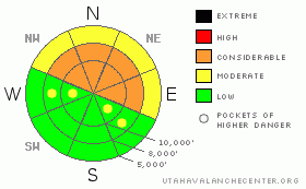
Danger by aspect and elevation on slopes approaching 35° or steeper.
(click HERE for tomorrow's danger rating)
|

Danger Rose Tutorial
|
A CONSIDERABLE avalanche danger remains on steep northwest through easterly facing slopes, where avalanches 2 to 4 feet deep, breaking near the ground, can be triggered. These avalanches can be triggered on, below or adjacent to steep slopes, and it may be the third or fourth person who triggers a slide. The likely hood of triggering one of these deep slides is slowly decreasing with time, but the consequences are not – deep slides to the ground are often deadly due to trauma or a deep burial. The lower angle, shady slopes have excellent turning and riding conditions.
|
|
|
CURRENT CONDITIONS |

|
Under partly cloudy skies, temperatures are in the upper teens to mid 20’s this morning. Winds are from the southwest, and light, averaging about 10 mph, with gusts to 20. Sunday’s small storm did a fine job freshening up turning and riding conditions, and shady slopes contain excellent, dry cold powder, though steeper sunny slopes are sporting a sun crust.
|
|
|
RECENT ACTIVITY |

|
No avalanches were reported from the backcountry yesterday. In the Ogden area mountains, where they received more snow on Sunday, explosive control work did release some new snow soft slab avalanches.
|
|
|
THREAT #1 |

|
| WHERE |
PROBABILITY |
SIZE |
TREND |

|
|
|
|
| |
|
|
Over the next
24 hours.
|
|
|
The snowpack is ever so slowly strengthening, and the places where one can trigger a deep slide are becoming more isolated…but no less dangerous if you do. Triggering a large avalanche continues to be a possibility on steep slopes wherever loose, weak snow is found near the base of the pack. The most suspect slopes are those facing northwest through east, approaching 35 degrees or steeper, at the mid and upper elevations. A slide would most likely be triggered in a shallow, rocky spot, such as a steep break over, and then propagate, breaking out the deep stuff.
No one goes into the back country to get caught, and the uncertainty and difficulty in predicting which slopes will slide makes skiing and riding the lower angle slopes a wise option. People with excellent avalanche and terrain evaluation skills are skiing steeper terrain by sticking to the bed surfaces of slopes that have slid, but this requires careful and knowledgeable evaluation.
|
|
|
THREAT #2 |

|
| WHERE |
PROBABILITY |
SIZE |
TREND |

|
|
|
|
| |
|
|
Over the next
24 hours.
|
|
|
In the Ogden area mountains, which received the most snow, activity has been reported both within the new snow and at the old snow interface. New snow soft slabs can be triggered on steep slopes, especially where wind drifted. Throughout the range, if you’re in a place where the wind speeds pick up this afternoon; sensitive drifts will become more widespread and should be avoided on steep slopes.
|
|
|
MOUNTAIN WEATHER |

|
Winter continues to limp along, with another small storm struggling through the ridge in an attempt to reach Utah tonight. Splitting the difference between the most ambitious and pessimistic computer models, storm totals of 4 to 9” are possible by tomorrow night. Today, there will be increasing clouds, with snow showers starting by evening. The southwesterly winds will also gradually increase, with the speeds across the high terrain reaching 20 to 30 mph, with gusts in the 40s. Temperatures will be balmy, with highs in the upper 20’s to mid 30’s. There will be another chance for light snowfall this weekend, though once again, the storm will favor southern Utah.
|
|
|
GENERAL ANNOUNCEMENTS |
|
Please contact Alta Central (801-742-2033) if you trigger a large avalanche in the backcountry, especially if you are adjacent to a ski area, to alert them to the slide and whether anyone is missing or not. Rescue teams can be exposed to significant hazard when responding to avalanches, and do not want to do so when unneeded. Thanks.
Discount Lift tickets: Ski Utah, Backcountry.com, Alta, Deer Valley, Park City, The Canyons, Wolf Mountain, Snowbasin, Beaver Mountain, Brighton, Sundance, and Solitude have donated a limited number of tickets for sale at discounted prices.
Wasatch Powderbird Guides flight plan.
Dawn Patrol Forecast Hotline, updated by 05:30:888-999-4019 option 8.
Daily observations are frequently posted by 10 pm each evening.
Free UAC iPhone app from Canyon Sports.
Subscribe to the daily avalanche advisory e-mail click HERE.
UDOT canyon closures UDOT at (801) 975-4838
We appreciate all your avalanche and snow observations. You can also call us at 801-524-5304 or 800-662-4140, or email to uac@utahavalanchecenter.org
Donate to your favorite non-profit – The Friends of the Utah Avalanche Center. The UAC depends on contributions from users like you to support our work.
The information in this advisory is from the U.S. Forest Service, which is solely responsible for its content. This advisory describes general avalanche conditions and local variations always occur.
Brett will update this forecast tomorrow morning. Thanks for calling.
|
|
|
This information does not apply to developed ski areas or highways where avalanche control is normally done. This advisory is from the U.S.D.A. Forest Service, which is solely responsible for its content. This advisory describes general avalanche conditions and local variations always occur. |
|
This advisory provided by the USDA Forest Service, in partnership with:
The Friends of the Utah Avalanche Center, Utah Division of State Parks and Recreation, Utah Division of Emergency Management, Salt Lake County, Salt Lake Unified Fire Authority and the friends of the La Sal Avalanche Center. See our Sponsors Page for a complete list. |


