AVALANCHE WARNING »
Dangerous avalanche conditions are occuring or are imminent.
Backcountry travel in avalanche terrain is not recommended.
|
 |
Notice: I have issued an avalanche warning for all the mountains of Utah. Very strong winds overnight combined with 8-12 inches of dense graupel continue to overload our fragile snowpack. Snow and winds should continue today with significant snow on Saturday. In northern Utah, avalanche danger is likely CONSIDERABLE this morning and will likely rise to HIGH later today. Southern Utah remains at HIGH. Skiers and boarders who want to recreate on steep slopes should go to the resorts today and through the weekend, where ski patrollers routinely knock down avalanches with explosives each morning before the public arrives. Snowmobilers should stay on groomed trails or recreate in gentler terrain. |
|
|
SPECIAL ANNOUNCEMENT |
 |
Little Cottonwood Canyon will be closed for avalanche control this morning from about 6 am until around 8 am. UDOT canyon closures UDOT at (801) 975-4838 |
|
|
BOTTOM LINE
Danger by aspect and elevation on slopes approaching 35° or steeper.
(click HERE for tomorrow's danger rating)
|
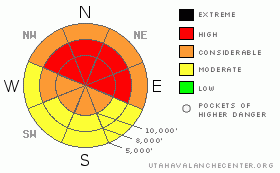
Danger Rose Tutorial
|
The avalanche danger is at least CONSIDERABLE on slopes approaching 35 degrees or steeper and will rise to HIGH today with the addition of more snow and wind. Avalanche danger is most pronounced on any steep slope with recent deposits of wind drifted snow and on all slopes that face the north and east quadrants of the compass, including at mid elevations.
(see the Danger Ratings Tutorial and the Danger Rose Tutorial) |
|
|
CURRENT CONDITIONS |

|
8-12 inches of snow has fallen in the past 24 hours with 5-8 inches of dense (12%) graupel overnight (that Styrofoam ball-type snow). Storm totals are up over 3 feet in many areas with over 3 inches of water weight. Winds blew very hard at times yesterday and blew even harder overnight with ridge top wind speeds 30, gusting to 50 from the southwest and 50, gusting to 70 on the more exposed peaks. Yesterday was very good powder, but the dense graupel with strong winds overnight has reportedly made the snow upside-down and slabby. |
|
|
RECENT ACTIVITY |

|
Yesterday, there were at least 3 close calls when skiers in separate, backcountry accidents were caught and carried in the avalanche they triggered. The closest call was on the steep, north side of Cardiff Peak, which is a backcountry area north of Alta. A skier visiting from Switzerland triggered a large avalanche 3-5 feet deep and went over a large cliff. He appeared to have broken his pelvis and femur and he was airlifted out (preliminary report in Current Conditions on our web site). Another skier triggered a wind slab and was caught in the infamous Hidden Canyon, an out-of-bounds area north of Brighton resort—the site of numerous close calls through the years. He grabbed a tree to keep from being carried down. The third accident occurred in the Logan area mountains as a skier had to grab a stump to keep from taking the full ride. See all the details in our Current Conditions section of our web site. |
|
|
THREAT #1 |

|
| WHERE |
PROBABILITY |
SIZE |
TREND |
|
|
|
|
| |
|
|
Over the next
48 hours.
|
|
|
The main problem today will be within the new snow from both slabs by density inversions within the new snow and from wind slabs deposited by the very strong winds. You should jump on test slopes and carefully test the surface snow as you travel. As always, avoid all steep slopes with recent deposits of wind drifted snow. |
|
|
THREAT #2 |

|
| WHERE |
PROBABILITY |
SIZE |
TREND |

|
|
|
|
| |
|
|
Over the next
48 hours.
|
|
|
The second problem is deep avalanches breaking down into the weak, faceted snow below our most recent storms. Although these avalanches are more difficult to trigger, they will be much larger and more dangerous. Be especially careful of the thin snowpack areas, which exist in most areas outside of the Cottonwood Canyons. Remember these faceted snow layers exist especially on mid elevation shady slopes, so you can easily be surprised in places you don’t normally see avalanches. |
|
|
MOUNTAIN WEATHER |

|
Salt Lake City had an all-time record low barometer reading last night as a huge low pressure system moves from California across Utah. We should continue to have strong, southwest, ridge top winds blowing 35, gusting to 50 and about 8 inches of relatively dense snow today, especially this afternoon. Winds should die down later today and we will get the main part of the storm on Saturday as we will get a more classic, colder, Cottonwood Canyons storm. We should add up to 3 feet of additional snow by Sunday morning. Today, ridge top temperatures should remain around the mid 20’s dropping into the mid teens tonight and on Saturday and down to 10 degrees on Saturday night. |
|
|
GENERAL ANNOUNCEMENTS |
Discount Lift tickets: Ski Utah, Backcountry.com, Alta, Deer Valley, Park City, The Canyons, Wolf Mountain, Snowbasin, Beaver Mountain, Brighton, Sundance, and Solitude have donated a limited number of tickets for sale at discounted prices.
Wasatch Powderbird Guides flight plan.
Dawn Patrol Forecast Hotline, updated by 05:30:888-999-4019 option 8.
Daily observations are frequently posted by 10 pm each evening.
Free UAC iPhone app from Canyon Sports.
Subscribe to the daily avalanche advisory e-mail click HERE.
UDOT canyon closures UDOT at (801) 975-4838
We appreciate all your avalanche and snow observations. You can also call us at 801-524-5304 or 800-662-4140, or email to uac@utahavalanchecenter.org
Donate to your favorite non-profit – The Friends of the Utah Avalanche Center. The UAC depends on contributions from users like you to support our work.
The information in this advisory is from the U.S. Forest Service, which is solely responsible for its content. This advisory describes general avalanche conditions and local variations always occur.
Bruce will update this forecast on Thursday morning. Thanks for calling. |
|
|
This information does not apply to developed ski areas or highways where avalanche control is normally done. This advisory is from the U.S.D.A. Forest Service, which is solely responsible for its content. This advisory describes general avalanche conditions and local variations always occur. |
|
This advisory provided by the USDA Forest Service, in partnership with:
The Friends of the Utah Avalanche Center, Utah Division of State Parks and Recreation, Utah Division of Emergency Management, Salt Lake County, Salt Lake Unified Fire Authority and the friends of the La Sal Avalanche Center. See our Sponsors Page for a complete list. |
