SPECIAL ANNOUNCEMENT |
 |
This week will be a game changer. The danger will rise with the storms, creating dangerous avalanche conditions. We expect to be issuing Avalanche Warnings perhaps by mid-week. |
|
|
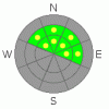
BOTTOM LINE
Danger by aspect and elevation on slopes approaching 35° or steeper.
(click HERE for tomorrow's danger rating)
|

Danger Rose Tutorial
|
The avalanche danger is MODERATE on any steep slopes with recent deposits of wind drifted snow, which will be most widespread on northwesterly to easterly facing slopes. There also remains an isolated chance of triggering a deeper slide failing on steep, isolated terrain features on westerly through northerly through southeasterly facing slopes. Slopes less steep than about 35 degrees, southerly facing slopes and low elevation slopes generally have a LOW avalanche danger. |
|
|
CURRENT CONDITIONS |

|
Deliverance is on the doorstep. An inch of snow has already fallen at our office at the National Weather Service building, a prelude to a week-long event that will bring snow, wind, and avalanches to the mountains. We expect increasingly stronger waves of moisture throughout the week riding a strong southwesterly flow. Southern Utah will carve out the lion’s share, but loose storm totals of 2-4’ shouldn’t let anyone feeling like they were left standing at the altar. |
|
|
RECENT ACTIVITY |

|
More activity in the backcountry yesterday. This one, a repeater, perhaps for the third time since mid-December. A ski-cut across a mid-slope cross-loaded gulley at 9700’ in northwest facing Wilson-into-Alexander pulled out a 1-2’ deep and 100’ wide hard slab, running 600’ vertical, piling debris 6’ deep. The failure plane was very weak large grained facets or depth hoar on the basal crust, just 10” above the ground. |
|
|
THREAT #1 |

|
| WHERE |
PROBABILITY |
SIZE |
TREND |
|
|
|
|
| |
|
|
Over the next
12 hours.
|
|
|
The first few teaser inches today should do little more than fill in the moonscape ruts and craters and nearly eroded Kodak-negative standing skin and sled tracks. The stronger accompanying winds may deposit thin soft and hard drifts below breakovers and along the lee of the ridge and sub-ridges. As the snow surface is a checkerboard of variability, so goes the bond of the new to the old. It’ll bond ok to the corrugated warm crusts on the sunnier aspects, and poorly to the hard wind crusts and patches of weak surface snow, particularly in the sheltered mid and low elevations. Mind the sluffing. |
|
|
THREAT #2 |

|
| WHERE |
PROBABILITY |
SIZE |
TREND |

|
|
|
|
| |
|
|
Over the next
12 hours.
|
|
|
Deeper hard slabs may still be triggered in steep rocky westerly to northerly to easterly facing slopes at the mid and upper elevations. Terrain that avalanched during the December 13 cycle may be the most prone, as well as isolated pockets along the Mill Creek or Park City ridgelines. These will again be players with this week’s storm. Mid pack weaknesses and basal weaknesses have otherwise gained strength over the last month. Still, as the last couple of days’ avalanches illustrate, continue to follow safe travel protocol by putting one person on the slope at a time. Make a plan. Have good communication. |
|
|
MOUNTAIN WEATHER |

|
We’ll see a couple-few inches this morning, a break for the afternoon, and then another, stronger wave tonight. 6-8” can be expected overnight, particularly in areas favored by a southwesterly flow. (Upper BCC, Provo, eastern Park City areas). The southwesterly winds should remain strong for the morning with something of a pause in the afternoon before increasing again overnight. Varying waves Wednesday into Thursday and again Thursday night and Saturday should finally bring much needed storm totals of feet instead of inches into the Wasatch and beyond. |
|
|
GENERAL ANNOUNCEMENTS |
Discount Lift tickets: Ski Utah, Backcountry.com, Alta, Deer Valley, Park City, The Canyons, Wolf Mountain, Snowbasin, Beaver Mountain, Brighton, Sundance, and Solitude have donated a limited number of tickets for sale at discounted prices.
Wasatch Powderbird Guides flight plan.
Dawn Patrol Forecast Hotline, updated by 05:30:888-999-4019 option 8.
Daily observations are frequently posted by 10 pm each evening.
Free UAC iPhone app from Canyon Sports.
Subscribe to the daily avalanche advisory e-mail click HERE.
UDOT canyon closures UDOT at (801) 975-4838
We appreciate all your avalanche and snow observations. You can also call us at 801-524-5304 or 800-662-4140, or email to uac@utahavalanchecenter.org
Donate to your favorite non-profit – The Friends of the Utah Avalanche Center. The UAC depends on contributions from users like you to support our work.
The information in this advisory is from the U.S. Forest Service, which is solely responsible for its content. This advisory describes general avalanche conditions and local variations always occur.
I will update this forecast on Tuesday morning. Thanks for calling. |
|
|
This information does not apply to developed ski areas or highways where avalanche control is normally done. This advisory is from the U.S.D.A. Forest Service, which is solely responsible for its content. This advisory describes general avalanche conditions and local variations always occur. |
|
This advisory provided by the USDA Forest Service, in partnership with:
The Friends of the Utah Avalanche Center, Utah Division of State Parks and Recreation, Utah Division of Emergency Management, Salt Lake County, Salt Lake Unified Fire Authority and the friends of the La Sal Avalanche Center. See our Sponsors Page for a complete list. |
