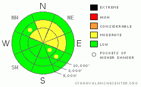
BOTTOM LINE
Danger by aspect and elevation on slopes approaching 35° or steeper.
(click HERE for tomorrow's danger rating)
|
Danger Rose Tutorial
|
The avalanche danger is MODERATE on any steep slopes with recent deposits of wind drifted snow, which will be most widespread on northerly and easterly facing slopes. There also remains an isolated chance of triggering a deeper slide failing on steep, isolated terrain features on northwest through southeasterly facing slopes. Slopes less steep than about 35 degrees, southerly facing slopes and low elevation slopes generally have a LOW avalanche danger.
|
|
|
CURRENT CONDITIONS |

|
Under partly cloudy skies, temperatures are mild once again, with most stations in the 20s to low 30s this morning. The southerly winds are generally in the 10 to 20 mph range, with a few stations in the Ogden and Provo area mountains averaging 30 mph. Wasatch powder has temporarily become a rare and endangered species, and the search for soft, untracked snow may have you poaching your best friends’ secret spots. Try obscure, mid elevation, wind sheltered, shady slopes, and avoid the widespread wind and solar damaged open areas. Riding lower angle slopes may reduce your exposure to hitting rocks or dropping through the punchy weak snow.
|
|
|
RECENT ACTIVITY |

|
A few isolated wind slabs were triggered yesterday. The largest, believed to be from an earlier wind event, was on a steep, north facing slope at 9,500', about 12-14" deep and 25-30' wide. The other, very shallow, few inches deep wind slab was on a northeast facing slope, and is an example of how sensitive wind drifts are when sitting on facets.
|
|
|
THREAT #1 |

|
| WHERE |
PROBABILITY |
SIZE |
TREND |
|
|
|
|
| |
|
|
Over the next
24 hours.
|
|
|
The southerly winds will continue to tease what little loose snow there is today, building a few more shallow drifts, many like thin sheets of plywood. On the more northerly facing slopes, where the drifts are sitting on weak surface snow, they could be surprisingly sensitive.
|
|
|
THREAT #2 |

|
| WHERE |
PROBABILITY |
SIZE |
TREND |

|
|
|
|
| |
|
|
Over the next
24 hours.
|
|
|
Just punching your ski pole into the snowpack or wallowing around on foot makes it obvious how generally weak the snow is. While there has been a lack of recent avalanche activity on these faceted weak layers, it is impossible to ignore them. If you choose to travel on mid and upper elevation steep slopes, especially those facing northwest through east, a conservative approach is necessary, as it is still possible to trigger a deeper slide. With a series of storms in the forecast, these weak layers are sure to provide avalanche activity later this week.
|
|
|
MOUNTAIN WEATHER |

|
There will be increasing clouds today, with even a few celebrity snowflakes possible this afternoon or tonight. Temperatures will warm to near 40 at 8,000’ and into the mid 20’s at 10,000’. The southerly winds will be on a gradual increase today, with 10 to 20 mph averages common, and the more exposed locations averaging closer to 25 mph, and gusting into the 30s. Mostly cloudy skies tonight, with the southerly winds notching it up another 5 to 10 mph. While a few inches of snow are possible on Monday, the first of a significant series of storms will arrive Monday night. If all goes well, may be able to take Wasatch powder off the endangered species watch list later this week.
|
|
|
GENERAL ANNOUNCEMENTS |
|
Discount Lift tickets: Ski Utah, Backcountry.com, Alta, Deer Valley, Park City, The Canyons, Wolf Mountain, Snowbasin, Beaver Mountain, Brighton, Sundance, and Solitude have donated a limited number of tickets for sale at discounted prices.
Wasatch Powderbird Guides flight plan.
Dawn Patrol Forecast Hotline, updated by 05:30:888-999-4019 option 8.
Daily observations are frequently posted by 10 pm each evening.
Free UAC iPhone app from Canyon Sports.
Subscribe to the daily avalanche advisory e-mail click HERE.
UDOT canyon closures UDOT at (801) 975-4838
We appreciate all your avalanche and snow observations. You can also call us at 801-524-5304 or 800-662-4140, or email to uac@utahavalanchecenter.org
Donate to your favorite non-profit – The Friends of the Utah Avalanche Center. The UAC depends on contributions from users like you to support our work.
The information in this advisory is from the U.S. Forest Service, which is solely responsible for its content. This advisory describes general avalanche conditions and local variations always occur.
Drew Hardesty will update this forecast on Monday morning. Thanks for calling.
|
|
|
This information does not apply to developed ski areas or highways where avalanche control is normally done. This advisory is from the U.S.D.A. Forest Service, which is solely responsible for its content. This advisory describes general avalanche conditions and local variations always occur. |
|
This advisory provided by the USDA Forest Service, in partnership with:
The Friends of the Utah Avalanche Center, Utah Division of State Parks and Recreation, Utah Division of Emergency Management, Salt Lake County, Salt Lake Unified Fire Authority and the friends of the La Sal Avalanche Center. See our Sponsors Page for a complete list. |
