BOTTOM LINE
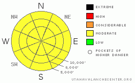
Danger by aspect and elevation on slopes approaching 35° or steeper.
(click HERE for tomorrow's danger rating)
|
Danger Rose Tutorial
|
This has to be what we'd call an "Experts-Only Moderate". Larger avalanches are possible in isolated areas, smaller avalanches are possible in many areas. Avoid the steep rocky sheltered terrain. You'll need to be 'game-on' on all the aspects at most elevations. Collapsing and cracking are surefire signs of localized instability. |
|
|
CURRENT CONDITIONS |

|
We have clear skies and ridgetop temperatures in the low 30’s. Ahead of the approaching splitter storm, the southwest winds have increased to 25-30mph with gusts to 40. Colder air moving in may not be enough to sweep out the valleys, but perhaps the winds will offer some help. Riding conditions are fair in the sheltered terrain. |
|
|
RECENT ACTIVITY |

|
Light wind, direct sun, and warming temps produced some minor wet natural and human-triggered sluffs on the steep sunny aspects. Collapsing on south-facing slopes near Gobbler’s Knob led a very experienced backcountry skier to call off his intended objective. The facet/crust layering on the sunny aspects remain active.
Years ago, I used to work for Al Brown. Hard to say if he was a philosopher who rode horses or a cowboy who just used to think a lot. Most of his time was spent up in the Blue Mountains, there just east of Cliff Ridge in the eastern Uintas. Not long ago, Tim Cahill relayed a story from riding with Al. “A man’s cowboy hat defines him,” Al said, looking sideways at any pretend cowboy with a stampede string – that extra leather loop used to keep a man’s hat down. “When you’re hat blows off – though it rarely should – it’s a sign to take stock. You’re obliged to think about it.” People with stampede strings, he stated as fact, failed to live sufficiently contemplative lives. |
|
|
THREAT #1 |

|
| WHERE |
PROBABILITY |
SIZE |
TREND |

|
|
|
|
| |
|
|
Over the next
24 hours.
|
|
|
With the warming temperatures, even the southerly aspects have shown their hand. Collapsing, cracking and avalanching on the southerly aspects are unusual – the weaknesses in Utah anyway, tend to be bridged by strong supportable crusts, destroyed by wind and sun, or metamorphosed by temperature gradients and/or free water. So when a very experienced backcountry skier backs off a south-facing slope and another is caught and has to dig in to the bed surface to avoid a ride, it’s a little like having your cowboy hat blown off. Time to take a step back and re-evaluate. |
|
|
THREAT #2 |

|
| WHERE |
PROBABILITY |
SIZE |
TREND |

|
|
|
|
| |
|
|
Over the next
24 hours.
|
|
|
Snow tests continue to provide evidence for unstable snow. It is, however, spatially variable across the range, if not the slope. They are most likely to be triggered on slopes that have previously released and then reloaded - on steep rocky west to north to east facing slopes. More prone areas include the Ogden area mountains, the Park City ridgeline, and Mill Creek. Slopes that did not release seem to be gaining some strength, though it's little consolation - by now which are which? Difficult saying unless you're out most days.
These may be 2-4' deep and up to a couple hundred feet wide. |
|
|
THREAT #3 |

|
| WHERE |
PROBABILITY |
SIZE |
TREND |

|
|
|
|
| |
|
|
Over the next
12 hours.
|
|
|
Stronger winds may help to offset the warm overnight lows, but it may all be academic. Be purpseful in your terrain choices if the sun has been on your terrain for a while. Avoid being in or above terrain traps or gullies if the wet loose snow starts to shed. Work to other, cooler aspects or drop your slope angles. |
|
|
MOUNTAIN WEATHER |

|
Sunny skies will give way to partly then mostly cloudy skies upon arrival of tonight's storm. The southwesterly winds are expected to remain 25-35mph along the high ridgelines. 10,000' temps will be in the mid to upper 30s. The bulk of the energy of tonight/tomorrow's storm dives south, but we may get 3-6" out of it by late Wednesday. High pressure builds for the rest of the week and into the weekend. |
|
|
GENERAL ANNOUNCEMENTS |
Discount Lift tickets: Ski Utah, Backcountry.com, Alta, Deer Valley, Park City, The Canyons, Wolf Mountain, Snowbasin, Beaver Mountain, Brighton, Sundance, and Solitude have donated a limited number of tickets for sale at discounted prices.
Wasatch Powderbird Guides flight plan.
Dawn Patrol Forecast Hotline, updated by 05:30:888-999-4019 option 8.
Daily observations are frequently posted by 10 pm each evening.
Free UAC iPhone app from Canyon Sports.
Subscribe to the daily avalanche advisory e-mail click HERE.
UDOT canyon closures UDOT at (801) 975-4838
Send us your avalanche and snow observations. You can also call 801-524-5304 or 800-662-4140, or email to uac@utahavalanchecenter.org
Donate to your favorite non-profit – The Friends of the Utah Avalanche Center. The UAC depends on contributions from users like you to support our work.
The information in this advisory is from the U.S. Forest Service, which is solely responsible for its content. This advisory describes general avalanche conditions and local variations always occur.
Ev will update this forecast tomorrow morning. Thanks for calling. |
|
|
This information does not apply to developed ski areas or highways where avalanche control is normally done. This advisory is from the U.S.D.A. Forest Service, which is solely responsible for its content. This advisory describes general avalanche conditions and local variations always occur. |
|
This advisory provided by the USDA Forest Service, in partnership with:
The Friends of the Utah Avalanche Center, Utah Division of State Parks and Recreation, Utah Division of Emergency Management, Salt Lake County, Salt Lake Unified Fire Authority and the friends of the La Sal Avalanche Center. See our Sponsors Page for a complete list. |
