SPECIAL ANNOUNCEMENT |
 |
Little Cottonwood Canyon will be closed tomorrow, Monday morning, for artillery firing from about 7 am to 8:30 am. For more information go to: UDOT or (801) 975-4838. |
|
|
BOTTOM LINE
Danger by aspect and elevation on slopes approaching 35° or steeper.
(click HERE for tomorrow's danger rating)
|
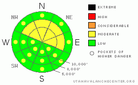
Danger Rose Tutorial
|
The avalanche danger is MODERATE on mid and upper elevation slopes facing northwest through east, where human triggered avalanches breaking near the ground are possible in isolated places, especially steep, rocky slopes with a shallow snowpack. The avalanche danger will also rise to MODERATE with sun and daytime heating for wet loose sluffs on steep sunny slopes and lower elevation slopes of all aspects. |
|
|
CURRENT CONDITIONS |

|
It’s another mild morning in the mountains, with temperatures in the upper teens to upper 20s under clear skies. The northwesterly winds are unusually light, generally less than 10 mph. Amid punchy, crusty and inconsistent surface snow, some areas of dense, soft snow do exist on wind sheltered, shady mid and upper elevation slopes. The crusted sun exposed and low elevation slopes should soften with day time heating and become more manageable. |
|
|
RECENT ACTIVITY |

|
No avalanches were reported from the backcountry yesterday, but there were several reports of collapsing. The spatial variability of the snow pack continues to increase, with the snow on some slopes strengthening, while on other slopes it’s weakening. |
|
|
THREAT #1 |

|
| WHERE |
PROBABILITY |
SIZE |
TREND |

|
|
|
|
| |
|
|
Over the next
24 hours.
|
|
|
The number one avalanche danger continues to be the possibility of triggering a slide on the weak faceted snow that’s close to the ground. In many places, you can feel this weak layer by just pushing your pole in to the ground. Here is another way of describing where you are most likely to trigger one of these deeper slides is this a diagram of where the human triggered avalanches have occurred in the Wasatch mountains the past few weeks. Part of the problem these days is that the snow pack layering varies widely, even across a single slope, so stability evaluation hard. However, careful route finding that avoids steep, shady slopes may be easier…and safer. |
|
|
THREAT #2 |

|
| WHERE |
PROBABILITY |
SIZE |
TREND |
|
|
|
|
| |
|
|
Over the next
10 hours.
|
|
|
The other concern for today is wet, loose sluffs. Lot of sunshine and warmer temperatures may cause the snow to heat up on steep sunny slopes today, resulting in human triggered and possibly natural sluffs. The low and mid elevation northerly facing slopes could also get in on the action if bands of high thin clouds move across later today, causing the snow on the shady slopes to heat. Roller balls are often a first sign of heating snow, and be sure to avoid the low elevation terrain traps such as gullies. |
|
|
MOUNTAIN WEATHER |

|
It’s going to feel like spring in the mountains today. Skies will be mostly sunny this morning, with high thin clouds drifting across this afternoon. Temperatures will warm into the upper 30’s below about 8,000’ and into the upper 20’s at 10,000’. The northwesterly winds will remain very light, generally less than 10 mph. A southwest flow will develop Monday into Tuesday, ahead of a splitting storm on Wednesday that will hopefully bring a few inches of snow to freshen up the old snow surface. |
|
|
GENERAL ANNOUNCEMENTS |
Discount Lift tickets: Ski Utah, Backcountry.com, Alta, Deer Valley, Park City, The Canyons, Wolf Mountain, Snowbasin, Beaver Mountain, Brighton, Sundance, and Solitude have donated a limited number of tickets for sale at discounted prices.
Wasatch Powderbird Guides flight plan.
Dawn Patrol Forecast Hotline, updated by 05:30:888-999-4019 option 8.
Daily observations are frequently posted by 10 pm each evening.
Free UAC iPhone app from Canyon Sports.
Subscribe to the daily avalanche advisory e-mail click HERE.
UDOT canyon closures UDOT at (801) 975-4838
Send us your avalanche and snow observations. You can also call 801-524-5304 or 800-662-4140, or email to uac@utahavalanchecenter.org
Donate to your favorite non-profit – The Friends of the Utah Avalanche Center. The UAC depends on contributions from users like you to support our work.
The information in this advisory is from the U.S. Forest Service, which is solely responsible for its content. This advisory describes general avalanche conditions and local variations always occur.
Drew will update this forecast on Monday morning. Thanks for calling. |
|
|
This information does not apply to developed ski areas or highways where avalanche control is normally done. This advisory is from the U.S.D.A. Forest Service, which is solely responsible for its content. This advisory describes general avalanche conditions and local variations always occur. |
|
This advisory provided by the USDA Forest Service, in partnership with:
The Friends of the Utah Avalanche Center, Utah Division of State Parks and Recreation, Utah Division of Emergency Management, Salt Lake County, Salt Lake Unified Fire Authority and the friends of the La Sal Avalanche Center. See our Sponsors Page for a complete list. |
