SPECIAL ANNOUNCEMENT |
 |
Going Big! Safely. A clinic on learning how to take on some of the big mountain terrain is FREE and open to the public tomorrow night, Thursday, January 7th, at Juan Diego High School. Athletes Julian Carr, Jen Hudak, Dash Longe, Cody Barnhill and Jaime Myersa, ski orthopedic surgeon Dr. Scholl and UAC’s Drew Hardesty will give advice on the preparation and safety behind the photos and movies of dropping the big lines. |
|
|
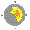
BOTTOM LINE
Danger by aspect and elevation on slopes approaching 35° or steeper.
(click HERE for tomorrow's danger rating)
|

Danger Rose Tutorial
|
The avalanche danger is CONSIDERABLE on all steep slopes with recent drifts of windblown snow, which will be most common along the ridgelines and on slopes facing northeast through southeast. CONSIDERABLE means that natural avalanches are possible and human triggered avalanche likely. There continues to be a MODERATE danger of triggering a deeper, more dangerous slide, possibly to the ground, on steep mid and upper elevation slopes facing northwest through north through east. |
|
|
CURRENT CONDITIONS |

|
Light snow is falling in the mountains, and temperatures are fairly warm – in the low to upper 20’s at most stations. But the eye catcher that finally woke me up this morning is the west to northwesterly winds. Average speeds are 15 to 20 mph with gusts in the 30’s, but across the high exposed terrain, speeds are averaging 30 to 40 mph, with gusts to 50. You’ll definitely want to head to wind sheltered, shady slopes today to find soft snow. |
|
|
RECENT ACTIVITY |

|
It was a very quiet day in the backcountry, with no new avalanches reported. |
|
|
THREAT #1 |

|
| WHERE |
PROBABILITY |
SIZE |
TREND |
|
|
|
|
| |
|
|
Over the next
12 hours.
|
|
|
Today’s number one avalanche concern will be new drifts of windblown snow. These denser slabby wind drifts will be sensitive to the weight of a person, and could overload the upper weak layers of near surface facets. If you trigger a wind drift, it could vary from a few inches deep up to two feet deep. The drifts will be most widespread along the high, easterly facing ridgelines, but also watch out for and avoid drifts on mid elevation slopes and around terrain features such as sub ridges, mid slope breakovers and gully walls. The drifts could look like rounded pillowy areas, and be either hard or soft. |
|
|
THREAT #2 |

|
| WHERE |
PROBABILITY |
SIZE |
TREND |

|
|
|
|
| |
|
|
Over the next
12 hours.
|
|
|
The other persistent avalanche problem is the weak facet layers mid pack and near the ground. People have continued to trigger slides on these layers the past week, the added wind load will increase the chances of triggering one of these deeper slides - either by a smaller slide stepping down, or just the weight of the wind drift itself. Once again, the weak snow is most widespread on mid and upper elevation northwest through easterly facing slopes, and slopes that have slid one or more times this year are especially weak and may be more likely to slide again. |
|
|
MOUNTAIN WEATHER |

|
A moist, northwesterly flow will bring light snow to the northern mountains today, with accumulations of 2 to 4 inches possible. The west to northwesterly winds will remain brisk, in the 20 to 30 mph range with gusts in the 40’s. The highest peaks and ridgelines could average 40 mph, with gusts in the 50’s. High temperatures will reach the low 30’s at 8,000’ and into the 20’s at 10,000’. An arctic front will move across tonight, dropping temperatures into the low teens and single digits. High pressure will rebuild on Friday, bringing sunny skies and mild temperatures to the mountains. |
|
|
GENERAL ANNOUNCEMENTS |
Discount Lift tickets: Ski Utah, Backcountry.com, Alta, Deer Valley, Park City, The Canyons, Wolf Mountain, Snowbasin, Beaver Mountain, Brighton, Sundance, and Solitude have donated a limited number of tickets for sale at discounted prices.
Wasatch Powderbird Guides flight plan.
Dawn Patrol Forecast Hotline, updated by 05:30:888-999-4019 option 8.
Daily observations are frequently posted by 10 pm each evening.
Free UAC iPhone app from Canyon Sports.
Subscribe to the daily avalanche advisory e-mail click HERE.
UDOT canyon closures UDOT at (801) 975-4838
Send us your avalanche and snow observations. You can also call 801-524-5304 or 800-662-4140, or email to uac@utahavalanchecenter.org
Donate to your favorite non-profit – The Friends of the Utah Avalanche Center. The UAC depends on contributions from users like you to support our work.
The information in this advisory is from the U.S. Forest Service, which is solely responsible for its content. This advisory describes general avalanche conditions and local variations always occur.
Brett will update this forecast on Thursday morning. Thanks for calling. |
|
|
This information does not apply to developed ski areas or highways where avalanche control is normally done. This advisory is from the U.S.D.A. Forest Service, which is solely responsible for its content. This advisory describes general avalanche conditions and local variations always occur. |
|
This advisory provided by the USDA Forest Service, in partnership with:
The Friends of the Utah Avalanche Center, Utah Division of State Parks and Recreation, Utah Division of Emergency Management, Salt Lake County, Salt Lake Unified Fire Authority and the friends of the La Sal Avalanche Center. See our Sponsors Page for a complete list. |
