SPECIAL ANNOUNCEMENT |
 |
Special Avalanche Advisory:
Heavy snowfall and wind will overload a very fragile and weak snow pack…rapidly creating dangerous avalanche conditions. Those without expert avalanche training and backcountry travel skills should avoid travel in and below avalanche terrain.
|
|
|
BOTTOM LINE
Danger by aspect and elevation on slopes approaching 35° or steeper.
(click HERE for tomorrow's danger rating)
|
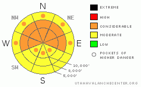
Danger Rose Tutorial
|
The avalanche danger will rapidly rise to CONSIDERABLE on steep west through north through easterly facing slopes at the low, mid and upper elevations, where shallow, new snow soft slabs will be easy to trigger, possibly from a distance. CONSIDERABLE means natural avalanches are possible and human triggered avalanches are likely. Other steep slopes will develop a MODERATE danger. In addition, deeper weak layers could become more active once again, including slopes that have slid, also deserving a solid CONSIDERABLE rating.
|
|
|
CURRENT CONDITIONS |

|
A vigorous storm is on our door step, with the initial light precipitation occurring on a southwesterly flow. 2 to 5 inches of snow have fallen in the mountains as of 6 am, temperatures are in the single digits to upper teens, and the southwesterly winds are increasing, averaging 10 to 15 mph, with gusts to 30. The more exposed stations have average speeds of 25 mph, with gusts in the 40’s. The new snow is falling on weak, soft recrystallized snow on many shady slopes, with a mix of supportable and breakable sun and winds crusts rounding out the old snow surfaces.
|
|
|
RECENT ACTIVITY |

|
A snowboarder took a 15 meter ride when he triggered a slide on Square Top yesterday. It was adjacent to the December 17th slide, broke out down to the rock slabs, but reportedly ran as loose snow and facets. In addition, yesterday’s inch or two of new snow made sluffs and even a 2 inch deep soft slab easy to trigger on steep slopes, all failing on the widespread surface hoar and near surface facts.
|
|
|
THREAT #1 |

|
| WHERE |
PROBABILITY |
SIZE |
TREND |

|
|
|
|
| |
|
|
Over the next
24 hours.
|
|
|
The avalanche danger will rapidly increase today as new snow and wind drifted snow overload the widespread weak surface snow (composed of surface hoar and near surface facets). I expect widespread new snow activity, with natural avalanche activity likely occurring by afternoon on very steep slopes during any periods of high snowfall rates, and in wind drifted areas. The heaviest snowfall is forecast to occur for several hours starting around 10 am when the cold front arrives. These new snow slides, while shallow, will be unusually reactive, responding to the slightest provocation and can be triggered from a distance and from below. Slopes steeper than about 40 degrees could run naturally, while the lower angle slopes will be just waiting for a trigger. This weak old surface snow layer exists on shady upper, mid and lower elevations – so watch out for steep slopes at all elevations, including in the trees and especially avoid terrain traps such as gullies, creek beds and road banks where even shallow slides can pile up snow deeply. On the southerly facing slopes, the new snow will be less sensitive, but with a good bed surface beneath, human triggered slides will be possible on steep slopes.
|
|
|
THREAT #2 |

|
| WHERE |
PROBABILITY |
SIZE |
TREND |
|
|
|
|
| |
|
|
Over the next
24 hours.
|
|
|
With the added weight of the new snow, the multiple deeper, weak faceted layers in the snowpack will once again become more sensitive to people riding and skiing. While I don’t expect spontaneous activity on these deeper weak layers, they will be more easily human triggered, resulting in deeper, wider and much more dangerous avalanches, potentially to the ground. These bigger slides can also be triggered from a distance, or from below. Both slopes that avalanched earlier this year and slopes that did not avalanche could fail.
|
|
|
MOUNTAIN WEATHER |

|
After several hours of light snow this morning on a southwesterly flow, the heaviest precipitation will occur with the arrival of the cold front late morning. Snowfall rates of over 2” per hour are possible for 3 to 4 hours. Generally, 9 to 14” of snow are expected by evening, with locally heavier amounts possible. Winds will shift to the northwest and increase, with averages in the 25 to 30 mph range across the higher ridgelines. An additional 3 to 6” of snow is possible tonight as the storm winds down by morning. A break in the action on Thursday, before a moist warm front crosses the area late Thursday through Saturday, bringing warming temperatures and 6 to 12” of dense snow by Friday night.
|
|
|
GENERAL ANNOUNCEMENTS |
|
Discount Lift tickets: Ski Utah, Backcountry.com, Alta, Deer Valley, Park City, The Canyons, Wolf Mountain, Snowbasin, Beaver Mountain, Brighton, Sundance, and Solitude have donated a limited number of tickets for sale at discounted prices.
For the Wasatch Powderbird Guides schedule go to their blog
Dawn Patrol Forecast Hotline, updated by 05:30: call 888-999-4019, option 8,
Daily observations are frequently posted by 10 pm each evening.
You can get a free iPhone application from Canyon Sports to display the Bottom Line.
To get a daily avalanche advisory e-mail click HERE.
For a text only version click the upper left link under Search
For canyon closures call UDOT at (801) 975-4838
Send us your avalanche and snow observations. You can also call 801-524-5304 or 800-662-4140, or email to uac@utahavalanchecenter.org
Donate to your favorite non-profit – The Friends of the Utah Avalanche Center. The UAC depends on contributions from users like you to support our work.
The information in this advisory is from the U.S. Forest Service, which is solely responsible for its content. This advisory describes general avalanche conditions and local variations always occur.
Brett Kobernik will update this forecast on Thursday morning. Thanks for calling.
|
|
|
This information does not apply to developed ski areas or highways where avalanche control is normally done. This advisory is from the U.S.D.A. Forest Service, which is solely responsible for its content. This advisory describes general avalanche conditions and local variations always occur. |
|
This advisory provided by the USDA Forest Service, in partnership with:
The Friends of the Utah Avalanche Center, Utah Division of State Parks and Recreation, Utah Division of Emergency Management, Salt Lake County, Salt Lake Unified Fire Authority and the friends of the La Sal Avalanche Center. See our Sponsors Page for a complete list. |
