SPECIAL ANNOUNCEMENT |
 |
We will be issuing intermittent avalanche advisories for the rest of the season, mostly in the afternoons. This advisory will cover Monday, April 20 through around Wednesday. April 22. |
|
|
BOTTOM LINE
Danger by aspect and elevation on slopes approaching 35° or steeper.
(click HERE for tomorrow's danger rating)
|
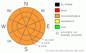
Danger Rose Tutorial
|
The avalanche danger will rise to CONSIDERABLE each day on and below steep slopes with daytime heating. CONSIDERABLE means human triggered slides are probable and natural avalanches possible. With multiple nonfreezing days and nights in the forecast, the chance of isolated, but very large, long running destructive avalanches is increasing. Even early starts will not be sufficient for safety, and backcountry travelers need to avoid steep slopes and avalanche runout zones. |
|
|
CURRENT CONDITIONS |

|
As a strong ridge of high pressure builds in to the area, the heat is on. Temperatures this morning are generally in the 30 to 40 degree range, about 5 to 10 degrees warmer than yesterday morning. Winds are light, less than 10 mph at all but the highest peaks, which are averaging near 20 mph. Clear skies each night will help to cool the snow surface, so there will be a very shallow, very short lived refreeze in the early mornings. Turning and riding conditions are rough – a brief window of supportable to breakable crusts each morning, will be rapidly followed by snow softening to wet slop by mid to late morning. |
|
|
RECENT ACTIVITY |

|
Widespread wet avalanche activity was reported from Sunday, mainly large wet sluffs, both natural and human triggered. Roller balls swarmed down steep slopes of all aspects, some with amazing 5 foot diameters. I’ll put together a gallery of some great photos HERE by around 8:30 am. |
|
|
THREAT #1 |

|
| WHERE |
PROBABILITY |
SIZE |
TREND |

|
|
|
|
| |
|
|
Over the next
24 hours.
|
|
|
It’s a heat wave – the combination of warm temperatures and direct sun are heating the snow surface on all aspects and elevations. The snow will be very slow to cool each night, and the refreeze each morning will be very short lived. The result is multiple wet snow avalanche issues. As the day heats up, both natural and easily triggered wet loose sluffs will be common, huge roller balls will be pin wheeling down slopes, and cornices can fail, possibly breaking back further than expected. If you head into the backcountry, very early starts and finishes are necessary. Once the snow heats up, avoid the steep slopes on all elevations and aspects, especially terrain traps such as gullies and creek bottoms or place where even a short ride can send you off a cliff or into trees. If you find yourself out too late, carefully use low angle terrain and ridge lines to exit the backcountry. |
|
|
THREAT #2 |

|
| WHERE |
PROBABILITY |
SIZE |
TREND |

|
|
|
|
| |
|
|
Over the next
24 hours.
|
|
|
It’s a heat wave – the combination of warm temperatures and direct sun are heating the snow surface on all aspects and elevations. The snow will be very slow to cool each night, and the refreeze each morning will be very short lived. The result is multiple wet snow avalanche issues. As the day heats up, both natural and easily triggered wet loose sluffs will be common, huge roller balls will be pin wheeling down slopes, and cornices can fail, possibly breaking back further than expected. If you head into the backcountry, very early starts and finishes are necessary. Once the snow heats up, avoid the steep slopes on all elevations and aspects, especially terrain traps such as gullies and creek bottoms or place where even a short ride can send you off a cliff or into trees. If you find yourself out too late, carefully use low angle terrain and ridge lines to exit the backcountry. |
|
|
MOUNTAIN WEATHER |

|
Strong high pressure will be the dominate feature over Utah through Wednesday, bringing clear skies, light and variable winds and scorching temperatures. 10,000’ free air temperatures will be in the mid 30’s today, creeping up into the low 40’s by Wednesday. 8,000’ temperatures will range from the mid 50’s today into the lower 60’s by Wednesday. Moisture will increase across Utah Wednesday afternoon through Friday, bringing high clouds and a chance of afternoon thunderstorms. However, it won’t do much to cool the sizzling temperatures, which may peak on Thursday. A possible cold front on Saturday may cool things off for a day or two. |
|
|
GENERAL ANNOUNCEMENTS |
We will be issuing intermittent afternoon avalanche advisories for the rest of the season, updating the advisory as conditions change.
Our web site is now formatted for iPhone. You can also download a free iPhone application from Canyon Sports to display the Bottom Line. Search for Utah Avalanche on the Apple's iPhone Apps page or in iTunes.
If you want to get this avalanche advisory e-mailed to you daily click HERE.
For a text only version, the link is on the left side bar, near the top.
UDOT highway avalanche control work info can be found by calling (801) 975-4838. Our statewide toll free line is 1-888-999-4019 (early morning, option 8).
Donate to your favorite non-profit – The Friends of the Utah Avalanche Center. The UAC depends on contributions from users like you to support our work. To find out more about how you can support our efforts to continue providing the avalanche forecasting and education that you expect please visitour Friends page.
We appreciate any and all late season avalanche and snow observations, so keep them coming!! Please leave us a message at (801) 524-5304 or 1-800-662-4140, or email us at uac@utahavalanchecenter.org. (Fax 801-524-6301).
The information in this advisory is from the U.S. Forest Service, which is solely responsible for its content. This advisory describes general avalanche conditions and local variations always occur. |
|
|
This information does not apply to developed ski areas or highways where avalanche control is normally done. This advisory is from the U.S.D.A. Forest Service, which is solely responsible for its content. This advisory describes general avalanche conditions and local variations always occur. |
|
This advisory provided by the USDA Forest Service, in partnership with:
The Friends of the Utah Avalanche Center, Utah Division of State Parks and Recreation, Utah Division of Emergency Management, Salt Lake County, Salt Lake Unified Fire Authority and the friends of the La Sal Avalanche Center. See our Sponsors Page for a complete list. |
