SPECIAL ANNOUNCEMENT |
 |
We will be issuing intermittent avalanche advisories for the rest of the season. We will likely issue advisories each afternoon this week through the storm cycle, and then go back to more intermittent advisories as the avalanche conditions stabilize. |
|
|
BOTTOM LINE
Danger by aspect and elevation on slopes approaching 35° or steeper.
(click HERE for tomorrow's danger rating)
|
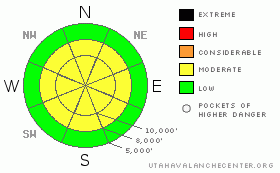
Danger Rose Tutorial
|
The avalanche danger will depend on how much snow we get Thursday night and how much sun we get on Friday, so it’s your responsibility to monitor the conditions carefully. Most likely we will have a MODERATE danger of both wet sluffs and dry slabs within the new snow.
|
|
|
CURRENT CONDITIONS |

|
Storm totals since Tuesday are over 3 feet of dense snow in the upper elevations of the Cottonwood Canyons and Park City with 3-4 inches of water weight. The storm was quite warm, so new snow amounts were very elevation dependent. For instance, places like Snowbasin, which is 2000 feet lower than the Cottonwood Canyon resorts, had the same water amounts but only 10 inches of snow.
|
|
|
RECENT ACTIVITY |

|
After widespread natural and human triggered avalanche activity within the new snow on Wednesday, it settled out quite a bit overnight, as is common with dense, warm snow. Avalanche control for the Cottonwood Canyon produced mostly shallow wind slabs in upper elevation wind exposed terrain with explosives, but there were a few larger slides 2 feet deep and close to 200 feet wide. In the clearing today, we could see some larger natural avalanches that occurred probably on Wednesday. Two notable ones were on the north facing slopes beneath the Pfeifferhorn and also on Red Baldy. These look to be over 2 feet deep and quite wide. There were also some cornice breaks today, both natural and human triggered.
|
|
|
THREAT #1 |

|
| WHERE |
PROBABILITY |
SIZE |
TREND |

|
|
|
|
| |
|
|
Over the next
24 hours.
|
|
|
Skies should begin to clear on Friday, so I’m thinking that our biggest problem will be damp and wet sluffs as all this new snow heats up in the strong spring sun. Most of the problems will likely occur on the steep, south facing slopes but they could occur on east and west facing slopes as well. I’m hoping that the wet activity will be fairly well-behaved since it’s warming up slowly and the existing snow is quite dense already.
|
|
|
THREAT #2 |

|
| WHERE |
PROBABILITY |
SIZE |
TREND |

|
|
|
|
| |
|
|
Over the next
24 hours.
|
|
|
I’m guessing that by Friday morning, all the existing snow from this storm will have settled out well and will be fairly stable. However, a few more inches of new snow is expected overnight, so you should use your usual bag of tricks to test the new snow to see how well it’s bonded to the old snow. Jump on test slopes, dig down with your hand and do slope cuts. The wind is supposed to be light but in case the wind blows harder than forecast, watch for the usual round of wind slabs near the ridges.
|
|
|
MOUNTAIN WEATHER |

|
The closed low pressure system is centered in southern Utah and should slowly move eastward. As the moist, unstable air rotates counterclockwise around it, some more moisture should wrap around and come into us from the north and northeast overnight, giving us a few more inches of snow. These kinds of spring storms are notoriously hard to forecast, so we could easily get no snow tonight or we could just as easily get a foot. Be sure to monitor the National Weather Service web site (or follow the links on our Weather Page) so you can see what happened overnight and the weather forecast for the day on Friday. Ridge top temperatures are forecast to be in the lower 20’s overnight with light winds from the north. Friday’s high should be in the mid 30’s and in the mid 40’s down at 8,000’. Then, we finally have a strong, high-pressure system moving in for the at least another week, so the weekend should be quite warm and sunny.
|
|
|
GENERAL ANNOUNCEMENTS |
We will be issuing intermittent avalanche advisories for the rest of the season. We will likely issue advisories each afternoon this week through the storm cycle, and then go back to more intermittent advisories as the avalanche conditions stabilize.
Our web site is now formatted for iPhone. You can also download a free iPhone application from Canyon Sports to display the Bottom Line. Search for Utah Avalanche on the Apple's iPhone Apps page or in iTunes.
If you want to get this avalanche advisory e-mailed to you daily click HERE.
For a text only version, the link is on the left side bar, near the top.
UDOT highway avalanche control work info can be found by calling (801) 975-4838. Our statewide toll free line is 1-888-999-4019 (early morning, option 8).
Donate to your favorite non-profit – The Friends of the Utah Avalanche Center. The UAC depends on contributions from users like you to support our work. To find out more about how you can support our efforts to continue providing the avalanche forecasting and education that you expect please visitour Friends page.
We appreciate any and all late season avalanche and snow observations, so keep them coming!! Please leave us a message at (801) 524-5304 or 1-800-662-4140, or email us at uac@utahavalanchecenter.org. (Fax 801-524-6301).
The information in this advisory is from the U.S. Forest Service, which is solely responsible for its content. This advisory describes general avalanche conditions and local variations always occur.
I will update this advisory on Friday afternoon. |
|
|
This information does not apply to developed ski areas or highways where avalanche control is normally done. This advisory is from the U.S.D.A. Forest Service, which is solely responsible for its content. This advisory describes general avalanche conditions and local variations always occur. |
|
This advisory provided by the USDA Forest Service, in partnership with:
The Friends of the Utah Avalanche Center, Utah Division of State Parks and Recreation, Utah Division of Emergency Management, Salt Lake County, Salt Lake Unified Fire Authority and the friends of the La Sal Avalanche Center. See our Sponsors Page for a complete list. |
