SPECIAL ANNOUNCEMENT |
 |
We will be issuing intermittent avalanche advisories for the rest of the season as conditions change. This advisory is for Saturday, April 11 and Sunday, April 12th. The next update will be Monday, April 13th. |
|
|
BOTTOM LINE
Danger by aspect and elevation on slopes approaching 35° or steeper.
(click HERE for tomorrow's danger rating)
|
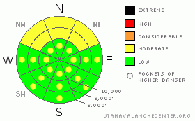
Danger Rose Tutorial
|
For Saturday, April 11: We’ll start with a mostly LOW danger this morning for most terrain. Pockets of MODERATE dot the steep, drifted, upper elevation terrain. It’s likely the danger will rise to MODERATE with rain on snow to about 7500’ or so…..and when the stronger northwest winds pick up in the afternoon.
For Sunday, April 12: Areas that see snow and wind will have a MODERATE danger for any new wind drifts. These should be most pronounced at the higher elevations on northeast through southeast facing slopes above about 9500’. This activity should be centered on the Provo and possibly the Salt Lake and Park City mountains. Clearing skies for mid to late Sunday will catalyze another round of wet sluffing on the steepest sun-exposed slopes. Fear the sun – and aim for skiing and riding in the shelter of the shadows. |
|
|
CURRENT CONDITIONS |

|
We’re just starting to see some wet flakes from a warm and wet storm system centered over the CA/AZ/NV border. Though it looks like it’s shaping up to be a Telluride special, the southern and possibly central Wasatch may get enough of the spillover to make it worth our while. Southeasterly winds have picked up, blowing 15-20mph, though I don’t expect them to be an issue until after the storm has pushed on to the east this afternoon. Temps remain warm after yesterday’s greenhousing and sit in the mid to upper 20’s. |
|
|
RECENT ACTIVITY |

|
Thursday’s activity: Thursday’s stronger northwesterly winds and foot of snow and graupel led to a fairly active day in the backcountry. Some shallow naturalling was reported from the height of the storm and one experienced skier was caught and carried after triggering a 1’ deep and 150’ wide soft slab off what we call Figure 8 Hill in the backbowls of the Millicent-Brighton backcountry. Tourers in Broads Fork of Big Cottonwood Canyon came upon an impressive debris pile from a large natural glide avalanche off the smooth rocky slabs near the Diving Board.
Friday’s activity: Lingering instabilities from the stronger winds/density breaks/graupel pools led to another skier catch-and-release in a shallow pocket on Patsy Marley above the headwaters of Little Cottonwood Canyon. The 1’ deep and 50’ wide pocket carried the skier only 20’ before he was able to get out of the flowing debris. Just down the street, a dawn patroller skinning above Little Superior triggered a shallow pocket 8-10” deep and 20’ wide. And, continuing still down the street, one of our observers triggered a wide, long running 6” deep pocket on the Coalpit Headwall. Good habits save lives – and in this case, again, a cornice stomp and drop allowed for effective mitigation of the manageable hazard. Further testament to his experience, he backed off the plan of linking it to the Y-Couloir, a very steep slide path above LCC as the greenhousing and warmth drove unstable conditions in unforgiving terrain. I would add that another very experienced observer skiied part of the way down a steep chute in upper Big Cottonwood only to only to boot back up and out due to increased danger in the mid-section. The best in the game are alert to changing conditions and times when they cannot safely manage the terrain and/or hazard anymore. Good work, gentlemen. |
|
|
THREAT #1 |

|
| WHERE |
PROBABILITY |
SIZE |
TREND |

|
|
|
|
| |
|
|
Over the next
24 hours.
|
|
|
Still, lingering, isolated pockets remain from the Thursday wind/snow event, particularly in the higher, more exposed terrain above about 9800’. Watch for drifting this morning with the gustier southeasterly winds and again this afternoon after the shift to northwest as the storm races to the east. |
|
|
THREAT #2 |

|
| WHERE |
PROBABILITY |
SIZE |
TREND |

|
|
|
|
| |
|
|
Over the next
24 hours.
|
|
|
I’d expect the new snow to bond quite well to the warmer snow surfaces. Any rain will not, so to speak, bond well, and we may see more widespread shallow sluffing at the mid and low elevation northerly aspects. It’s all about what is seeing the rapid change for the first time. |
|
|
MOUNTAIN WEATHER |

|
With overcast skies, we may see a few wet inches of snow today, with optimistic totals of 6-10” by tomorrow. The northwest winds will increase to 30-35mph this afternoon, easily drifting whatever falls today in the highest terrain. Temps will be in the mid-30’s at 8000’ and upper 20’s at 10,000’. Weak ridging fills in behind the storm tomorrow into Monday with a much colder storm on the way for Tuesday into Wednesday. It’s looking similar to the ones we had in late March through early April. |
|
|
GENERAL ANNOUNCEMENTS |
Our web site is now formatted for iPhone. You can also download a free iPhone application from Canyon Sports to display the Bottom Line. Search for Utah Avalanche on the Apple's iPhone Apps page or in iTunes.
Beacon training parks are up and running! There is one at Snowbasin, one on the Park City side at the top of Canyon’s gondola toward the Tombstone lift, one in Little Cottonwood near the Snowbird parking structure on the bypass road, and in Big Cottonwood a training park is at the west end of Solitude's lower parking lot.
If you want to get this avalanche advisory e-mailed to you daily click HERE.
For a text only version, the link is on the left side bar, near the top.
UDOT highway avalanche control work info can be found by calling (801) 975-4838. Our statewide toll free line is 1-888-999-4019 (early morning, option 8).
Donate to your favorite non-profit – The Friends of the Utah Avalanche Center. The UAC depends on contributions from users like you to support our work. To find out more about how you can support our efforts to continue providing the avalanche forecasting and education that you expect please visitour Friends page.
Your snow and avalanche observations can save someone’s life. Please let us know what you're seeing by leaving a message at (801) 524-5304 or 1-800-662-4140, or email us at uac@utahavalanchecenter.org. (Fax 801-524-6301).
The information in this advisory is from the U.S. Forest Service, which is solely responsible for its content. This advisory describes general avalanche conditions and local variations always occur.
Bruce will update this advisory on Monday. |
|
|
This information does not apply to developed ski areas or highways where avalanche control is normally done. This advisory is from the U.S.D.A. Forest Service, which is solely responsible for its content. This advisory describes general avalanche conditions and local variations always occur. |
|
This advisory provided by the USDA Forest Service, in partnership with:
The Friends of the Utah Avalanche Center, Utah Division of State Parks and Recreation, Utah Division of Emergency Management, Salt Lake County, Salt Lake Unified Fire Authority and the friends of the La Sal Avalanche Center. See our Sponsors Page for a complete list. |
