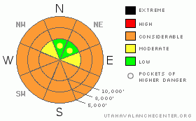
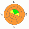
BOTTOM LINE
Danger by aspect and elevation on slopes approaching 35° or steeper.
(click HERE for tomorrow's danger rating)
|
Danger Rose Tutorial
|
The danger for wet avalanches will rapidly rise to CONSIDERABLE with sun and daytime heating. Human triggered wet sluffs will be probable and natural avalanche activity possible on steep, sunny slopes and low elevation slopes of all aspects. Get off of and out from under steep sunny slopes once the day heats up. There are pockets of MODERATE danger on mid and upper elevation slopes with cold, dry snow, where sluffs and foot deep soft slabs can be triggered. |
|
|
CURRENT CONDITIONS |

|
The blitz is finally over. In the past two weeks, the Ogden and Provo mountains received around 50”, while the Cottonwoods have been choked with over 150” of snow, with 80 to 100 inches falling along the Park City ridgeline. And this wasn’t just any old snow – but quintessential Utah powder. Today, sun and rapidly warming temperatures will quickly turn the widespread perfect powder damp on all but mid and upper elevation northerly facing slopes. So head out early today! Under partly cloudy skies, temperatures are in the 15 to 20 degree range this morning, and the winds are very light, less than 10 mph from the northwest. |
|
|
RECENT ACTIVITY |

|
There was no avalanche activity reported from Ogden or Provo area mountains yesterday. However, there were multiple close calls in the Cottonwoods yesterday, all with happy endings. The avalanche activity seemed centered in Big Cottonwood Canyon - easily triggered new snow sluffs and soft slabs were the norm, with a small natural sluff cycle occurring mid morning. Most of the triggered slabs were less than a foot deep, up to 100’ wide, some were running over 500 vertical feet. However, 4 people were partially buried near the base of the east couloir of Kessler (below Catcher’s Mitt) when a natural came down, estimated to be 2 to 4' deep by 200' wide. Another party on Kessler triggered 150' wide by 1-2 ft deep slide on up track, well east of the Lawnmower. (Photos posted later this morning.) Most of this activity occurred during a time when temperatures in Big Cottonwood jumped almost 15 degrees, and the clouds had thinned, allowing some heating from the sun. |
|
|
THREAT #1 |

|
| WHERE |
PROBABILITY |
SIZE |
TREND |
|
|
|
|
| |
|
|
Over the next
12 hours.
|
|
|
The heat is on. The combination of warming temperatures and direct sun could let loose a deluge of wet snow sluffs and slabs over the next three days, and at times the onset of wet activity could be fast and furious. While the general picture is predictable - daytime heating = wet avalanches - the details can be tricky. Different aspects, elevations and slope angles heat up at different times, with any periods of thin clouds increasing the heating on northerly facing slopes. Try to anticipate well ahead, constantly evaluating where you are and where you need to go to keep out of avalanche paths that may release naturally. Realize stability can change fast. Avoid travel on and below steep slopes and in avalanche run out zones as the day heats up, and stay out of gullies and terrain traps. Roller balls and being able to push or trigger damp sluffs can be first clues that the snow is heating up. |
|
|
THREAT #2 |

|
| WHERE |
PROBABILITY |
SIZE |
TREND |

|
|
|
|
| |
|
|
Over the next
24 hours.
|
|
|
On slopes with cool, dry snow, there could be a few lingering instabilities in the new snow. Expect to trigger sluffs on steep slopes and rollovers, and triggering a few foot deep soft slabs may be possible. They’re just big enough to catch and carry, and most dangerous in terrain with a bad run out into trees of off a cliff. Watch for cracking for the surface snow, jump on test slopes, and use good slope cuts. Cornices are huge, and continue to break back further than expected. |
|
|
MOUNTAIN WEATHER |

|
The heat is on! High pressure is building in, and this morning’s partly cloudy skies should clear by noon, with temperatures warming into the upper 20’s at 10,000’ and the upper 30’s at 8,000’. The northerly winds will remain very light today, averaging less than 15 mph. Significant warming will occur Monday and Tuesday as the ridge strengthens over Utah, with 10,000’ temperatures warming into the mid 30s. Two warmer storm systems are forecast to bring snow to the mountains around Wednesday, and again next Friday.
|
|
|
GENERAL ANNOUNCEMENTS |
Wasatch Powderbird Guides didn’t get out on Saturday, and today they will be in American Fork and the Session. Check their operations planning page is here.
Our web site is now formatted for iPhone. You can also download a free iPhone application from Canyon Sports to display the Bottom Line. Search for Utah Avalanche on the Apple's iPhone Apps page or in iTunes.
Beacon training parks are up and running! There is one at Snowbasin, one on the Park City side at the top of Canyon’s gondola toward the Tombstone lift, one in Little Cottonwood near the Snowbird parking structure on the bypass road, and in Big Cottonwood a training park is at the west end of Solitude's lower parking lot.
If you want to get this avalanche advisory e-mailed to you daily click HERE.
For a text only version, the link is on the left side bar, near the top.
UDOT highway avalanche control work info can be found by calling (801) 975-4838. Our statewide toll free line is 1-888-999-4019 (early morning, option 8).
Donate to your favorite non-profit – The Friends of the Utah Avalanche Center. The UAC depends on contributions from users like you to support our work. To find out more about how you can support our efforts to continue providing the avalanche forecasting and education that you expect please visitour Friends page.
Your snow and avalanche observations can save someone’s life. Please let us know what you're seeing by leaving a message at (801) 524-5304 or 1-800-662-4140, or email us at uac@utahavalanchecenter.org. (Fax 801-524-6301).
The information in this advisory is from the U.S. Forest Service, which is solely responsible for its content. This advisory describes general avalanche conditions and local variations always occur.
I will update this advisory by 7:30 tomorrow morning. |
|
|
This information does not apply to developed ski areas or highways where avalanche control is normally done. This advisory is from the U.S.D.A. Forest Service, which is solely responsible for its content. This advisory describes general avalanche conditions and local variations always occur. |
|
This advisory provided by the USDA Forest Service, in partnership with:
The Friends of the Utah Avalanche Center, Utah Division of State Parks and Recreation, Utah Division of Emergency Management, Salt Lake County, Salt Lake Unified Fire Authority and the friends of the La Sal Avalanche Center. See our Sponsors Page for a complete list. |
