BOTTOM LINE
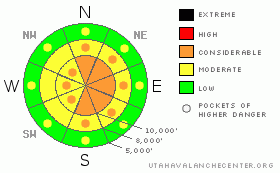
Danger by aspect and elevation on slopes approaching 35° or steeper.
(click HERE for tomorrow's danger rating)
|
Danger Rose Tutorial
|
The avalanche danger is CONSIDERABLE on steep, wind drifted slopes, with both human triggered and natural avalanches up to two feet deep possible. Out of the wind affected terrain, steep mid and upper elevation slopes have a generally MODERATE danger. There continue to be pockets of MODERATE danger for lingering wet avalanches at low and mid elevations until the snowpack cools. If you stay on wind sheltered slopes less steep than about 35 degrees, the avalanche danger is mostly LOW. |
|
|
CURRENT CONDITIONS |

|
Our stalled winter finally got a jump start last night, with a cold Pacific storm delivering a nice shot of snow. Most stations in the Ogden and Park City mountains are nearing 9”, with the Cottonwoods pushing a foot. The Provo mountains received 3 to 8”, but may catch up as the storm continues to drop south. It’s an excellent start to filling in the old tracks and sestrugi. Just when we thought we’d ditched the pulverizing winds, they annoyingly increased again in the past few hours. The more exposed stations in the Provo area mountains are blown in the 20 to 30 mph range for a few hours, with gusts in the 40s and 50s from a westerly direction. Mid elevation stations have speeds of 10 to 15 mph, with gusts in the 20s and 30s. |
|
|
RECENT ACTIVITY |

|
The resort snow cat drivers in Little Cottonwood have reported natural avalanche activity this morning in wind effected terrain. Yesterday, no new avalanches were reported, though we did receive a report of a notable wet slab triggered Tuesday - see photos. If you’re heading north, a sizable slide failed on surface hoar north of Logan. |
|
|
THREAT #1 |

|
| WHERE |
PROBABILITY |
SIZE |
TREND |

|
|
|
|
| |
|
|
Over the next
12 hours.
|
|
|
Almost foot of new snow, 30 mph sustained winds, slick old snow surfaces – you got it - expect easily triggered avalanches in steep wind drifted terrain, with drifts up to 2 feet deep. If the winds persist, natural avalanches will continue. Slides may go faster and further than expected on some slopes where they are running on a smooth old snow surface of sun crusts, wind crusts, or hard wind board. Even out of wind effect terrain, anticipate the possibility of poor bonding to the old snow surface, with sluffs and soft slabs entraining snow down the track in continuously steep terrain. A very few of the old hard wind drifts might get in on the action and release on a very steep slope, located mostly mid slope, off ridgelines. |
|
|
THREAT #2 |

|
| WHERE |
PROBABILITY |
SIZE |
TREND |

|
|
|
|
| |
|
|
Over the next
24 hours.
|
|
|
As the warm, wet snowpack slowly cools, it may still be possible to trigger a wet avalanche today. There is the potential for wet loose sluffs at the lower elevations, especially dangerous when associated with terrain traps such as gullies. A few “corn slabs” might be possible at low and mid elevations, where there is a frozen snow layer above still wet snow. Continue to avoid travel below any glide cracks in the usual spots in Stairs Gulch, Mill B South, and Broads Fork of Big Cottonwood Canyon. |
|
|
MOUNTAIN WEATHER |

|
As the cold front moves south, the heavy snowfall in the northern mountains will decrease and become more showery by mid morning. Additional amounts of 1 to 3” are expected, with locally higher amounts possible. Temperatures will be in the low 20s at 8,000’ and near 10 at 10,000’. Winds will be from a southwest to westerly direction, in the 5 to 15 mph range with gusts to 25. More exposed locations will have averages close to 25 mph, with gusts in the 40’s and 50’s. The next storm system will cross the area Friday afternoon through Friday night, with another shot of snow and dropping temperatures into the low single digits. A third storm is on track for late Sunday into Monday. |
|
|
GENERAL ANNOUNCEMENTS |
Our web page is now mobile-friendly for users of iPhone and iPod Touch.
Wasatch Powderbird Guides have been grounded due to weather. Their operations planning page is here.
Beacon training parks are up and running! There is one at Snowbasin, one on the Park City side at the top of Canyon’s gondola toward the Tombstone lift, one in Little Cottonwood near the Snowbird parking structure on the bypass road, and in Big Cottonwood a training park is at the west end of Solitude's lower parking lot.
If you want to get this avalanche advisory e-mailed to you daily click HERE.
For a text only version, the link is on the left side bar, near the top.
UDOT highway avalanche control work info can be found by calling (801) 975-4838. Our statewide toll free line is 1-888-999-4019 (early morning, option 8).
The UAC depends on contributions from users like you to support our work. To find out more about how you can support our efforts to continue providing the avalanche forecasting and education that you expect please visitour Friends page.
Your snow and avalanche observations can save someone’s life. Please let us know what you're seeing by leaving a message at (801) 524-5304 or 1-800-662-4140, or email us at uac@utahavalanchecenter.org. (Fax 801-524-6301).
The information in this advisory is from the U.S. Forest Service, which is solely responsible for its content. This advisory describes general avalanche conditions and local variations always occur.
Bruce Tremper will update this advisory by 7:30 tomorrow morning. |
|
|
This information does not apply to developed ski areas or highways where avalanche control is normally done. This advisory is from the U.S.D.A. Forest Service, which is solely responsible for its content. This advisory describes general avalanche conditions and local variations always occur. |
|
This advisory provided by the USDA Forest Service, in partnership with:
The Friends of the Utah Avalanche Center, Utah Division of State Parks and Recreation, Utah Division of Emergency Management, Salt Lake County, Salt Lake Unified Fire Authority and the friends of the La Sal Avalanche Center. See our Sponsors Page for a complete list. |
