Provo Avalanche Advisory

Forecaster: Drew Hardesty

BOTTOM LINE

Danger by aspect and elevation on slopes approaching 35° or steeper.
(click HERE for tomorrow's danger rating)


Danger Rose Tutorial

You’ll find areas of soggy Considerable in the mid to low elevation shady slopes. There’s no secret here: watch how the snow reacts to your board(s) or ride, and plan your uptracks and exits accordingly to avoid pushing the saturating glop and yourself into a terrain trap or through the trees. This debris sets up like concrete – there’ll be no miraculous self-extrication this go-around.


CURRENT CONDITIONS

Wet, warm and windy. The precipitation seemed hit or miss, with the Provo mountains picking up what looks to be almost a third of an inch of rain up to about 8000’, the Ogden mountains perhaps a third to a half inch of rain, and the Cottonwoods and Park City areas perhaps a tenth of an inch or so. Not that it rained on our parade…..the snow conditions have been deteriorating since Saturday. It is instructive that guide and observer Dan Griffith, who loves skiing as much as anyone, finally had some unprintable things to say about the riding conditions. At least the winds have picked up from the southwest, blowing 20-25mph with the more exposed anemometers spinning at 35-40mph with gusts to 60. Temps are in the low 30’s at 8000’.


RECENT ACTIVITY

Warm temperatures and a high rain/snow line provided a shock to the system of the shady low to mid elevation snow, producing at least one sizeable debris pile. Even a few diehards had to duck to avoid the monster pinwheels they initiated.


THREAT #1

WHERE PROBABILITY SIZE TREND
      Over the next 24 hours.

In the snow and avalanche world, we often find avalanches in areas that see rapid change. Burst in snowfall intensity? Avalanches. Rapid build-up of blowing and drifting snow? Avalanches. Rapidly warming temperatures and/or rain? Avalanches. As they say in the south (and I’m from the south), “if dey ain’t nuthin’ happenin’, dey ain’t nuthin’ gonna happen”. And the converse is true. The southerly and exposed “off” aspects have already been punished by the sun – it’s the northerly and more sheltered aspects experiencing some of the rapid change.


THREAT #2

WHERE PROBABILITY SIZE TREND
      Over the next 24 hours.

Play along the ridgelines long enough and the old saying will hold true: "There's two types of people out there: those that have a cornice story, and those that're gonna." Continue to give a wide berth to the yawning waves.


THREAT #3

WHERE PROBABILITY SIZE TREND
No size identified.
No trend identified.

Low danger - common sense normal caution...stronger winds > potential for smaller wind pockets up high


MOUNTAIN WEATHER

Mild, spotty west to southwest flow. It’s partly cloudy to mostly cloudy and we may squeeze an inch or three at the higher elevations, particularly north of I-80. The rain/snow line should linger at 8000’ and the winds are expected to blow 20-25mph with 11,000’ speeds of 30-35mph. We stay in this pattern for the remainder of the week, with lowering snow levels on Friday/Friday night. Taxes, anyone?


GENERAL ANNOUNCEMENTS

Our web page is now mobile-friendly for users of iPhone and iPod Touch.

Wasatch Powderbird Guides operations planning page is here.

Beacon training parks are up and running! There is one at Snowbasin, one on the Park City side at the top of Canyon’s gondola toward the Tombstone lift, one in Little Cottonwood near the Snowbird parking structure on the bypass road, and in Big Cottonwood a training park is at the west end of Solitude's lower parking lot.

If you want to get this avalanche advisory e-mailed to you daily click HERE.

For a text only version, the link is on the left side bar, near the top.

UDOT highway avalanche control work info can be found by calling (801) 975-4838. Our statewide toll free line is 1-888-999-4019 (early morning, option 8).

The UAC depends on contributions from users like you to support our work. To find out more about how you can support our efforts to continue providing the avalanche forecasting and education that you expect please visitour Friends page.

Your snow and avalanche observations can save someone’s life. Please let us know what you're seeing by leaving a message at (801) 524-5304 or 1-800-662-4140, or email us at uac@utahavalanchecenter.org. (Fax 801-524-6301).

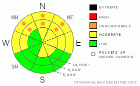
The information in this advisory is from the U.S. Forest Service, which is solely responsible for its content. This advisory describes general avalanche conditions and local variations always occur.

I will update this advisory by 7:30 tomorrow morning.


This information does not apply to developed ski areas or highways where avalanche control is normally done.  This advisory is from the U.S.D.A. Forest Service, which is solely responsible for its content. This advisory describes general avalanche conditions and local variations always occur.


This advisory provided by the USDA Forest Service, in partnership with:

The Friends of the Utah Avalanche Center, Utah Division of State Parks and Recreation, Utah Division of Emergency Management, Salt Lake County, Salt Lake Unified Fire Authority and the friends of the La Sal Avalanche Center. See our Sponsors Page for a complete list.