SPECIAL ANNOUNCEMENT |
 |
Our partners, the Friends of the Utah Avalanche Center, with the Snowbird Renaissance Center, are hosting the annual Utah Backcountry Awareness Benefit Dinner and Silent Auction Friday, February 13th, from 5:30-9:00 pm, at Snowbird. It’s a bit of a splurge, but it’s always a very enjoyable evening. Included is dinner, a silent auction, inspirational speaker Chris Waddell chronicling how he overcame a life-changing college skiing accident to become the most decorated male skier in Paralympic history, plus live entertainment by “Stormy Mountain Boys”. For details and tickets, go to the Snowbird Renaissance Center's web site. |
|
|
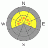
BOTTOM LINE
Danger by aspect and elevation on slopes approaching 35° or steeper.
(click HERE for tomorrow's danger rating)
|
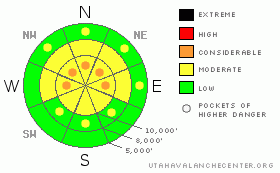
Danger Rose Tutorial
|
The avalanche danger is MODERATE with pockets of CONSIDERABLE on mid and upper elevation slopes steeper than about 35 degrees, facing northwest through east. CONSIDERABLE means human triggered slides are probable and natural avalanche possible, especially if the winds increase at any point today. Remember, many of the Provo area ice climbs are in the tracks and runout zones of avalanche paths. |
|
|
CURRENT CONDITIONS |

|
Yesterday’s quiet little storm favored the Provo area mountains with just over a foot of new snow, with 1.3 inches of water, at 7,500’. I would suspect there is even more at the higher elevations. Elsewhere, in the northern mountains from Ogden to the Cottonwoods, most areas receiving 8 to 11” above about 8,000’. Densities averaged 6-7%. This morning, skies are overcast, temperatures are in the upper teens to low twenties, and the southerly winds are surprisingly light. Even the exposed stations are averaging only 10 mph, and gusts are less than 20. The new snow isn’t quite enough to fill in all the old tracks, but you’ll feel them less on the shady slopes with underlying soft snow and on lower angle slopes. |
|
|
RECENT ACTIVITY |

|
Yesterday, sluffs, super-soft slabs and wind drifts were easily triggered within the new snow on steep slopes, most sensitive and longest running on slopes facing northwest through east. Size wise, most of these slides were harmless, but some were big enough to catch and carry an unaware person. The snow was the most cracky and sensitive in terrain affected by the few hours of stronger, gusty winds yesterday morning. |
|
|
THREAT #1 |

|
| WHERE |
PROBABILITY |
SIZE |
TREND |

|
|
|
|
| |
|
|
Over the next
24 hours.
|
|
|
Once again, I expect it will be easy to trigger sluffs and very soft slabs in the new snow today, especially on the shady mid and upper elevation slopes. Here the new snow landed on weaker sugary facets and surface hoar. These are more persistent weak layers, and remain sensitive. In areas with over a foot of new snow, use only test slopes for slope cutting and cornice kicking. As you travel, consider the terrain you’re in – the Provo mountains have many long, continuously steep slopes, where even a small slide can travel long distances, entraining a lot of snow. Also avoid terrain where a ride would take you into trees, a gully or off a cliff.
With warm temperatures, damp sluffs will be possible on steep, lower elevation slopes, including northerly facing ones. |
|
|
THREAT #2 |

|
| WHERE |
PROBABILITY |
SIZE |
TREND |
|
|
|
|
| |
|
|
Over the next
24 hours.
|
|
|
The current wind speeds are so slow; it’s hard to believe they’ll remain like that all day. So if the southerly winds increase where you are today, they will rapidly whip up some deeper sensitive wind drifts along the ridgelines, loading the same northerly facing slopes with the weaker underlying snow. |
|
|
MOUNTAIN WEATHER |

|
Another band of moisture is struggling north this morning, and will generate mostly cloudy skies and light snow showers to the Provo, Park City and Salt Lake mountains. A trace to 2 inches of snow is possible today and again tonight. The southerly winds may increase into the 10 to 20 mph range, with gusts to 25. Temperatures will be in the low 30s at 8,000’ and the low 20s at 10,000’. Mostly cloudy skies with occasional snow showers will continue through Monday, with a better chance for significant snow Monday night as a cold front moves through. |
|
|
GENERAL ANNOUNCEMENTS |
Wasatch Powderbird Guides did not fly on Friday and most likely won’t fly today due to weather. Operations planning page is here.
The last of the Beaver Mountain Discount tickets have been reduced to $35, with all proceeds going to the Friends of the Utah Avalanche Center. Click HERE for details.
Tickets are now available for the annual Backcountry Awareness Dinner on February 13th, with registration through the Snowbird Renaissance Center.
Beacon training parks are up and running! There is one at Snowbasin, one on the Park City side at the top of Canyon’s gondola, one in Little Cottonwood near the Snowbird parking structure on the bypass road, and in Big Cottonwood a training park is at the west end of Solitude's lower parking lot.
If you want to get this avalanche advisory e-mailed to you daily click HERE.
For a text only version, the link is on the left side bar, near the top.
UDOT highway avalanche control work info can be found by calling (801) 975-4838. Our statewide toll free line is 1-888-999-4019 (early morning, option 8).
The UAC depends on contributions from users like you to support our work. To find out more about how you can support our efforts to continue providing the avalanche forecasting and education that you expect please visitour Friends page.
Your snow and avalanche observations help everyone in the backcountry community. Please let us know what you're seeing by leaving a message at (801) 524-5304 or 1-800-662-4140, or email us at uac@utahavalanchecenter.org. (Fax 801-524-6301).
The information in this advisory is from the U.S. Forest Service, which is solely responsible for its content. This advisory describes general avalanche conditions and local variations always occur.
Brett will update this advisory by 7:30 tomorrow morning. |
|
|
This information does not apply to developed ski areas or highways where avalanche control is normally done. This advisory is from the U.S.D.A. Forest Service, which is solely responsible for its content. This advisory describes general avalanche conditions and local variations always occur. |
|
This advisory provided by the USDA Forest Service, in partnership with:
The Friends of the Utah Avalanche Center, Utah Division of State Parks and Recreation, Utah Division of Emergency Management, Salt Lake County, Salt Lake Unified Fire Authority and the friends of the La Sal Avalanche Center. See our Sponsors Page for a complete list. |
