SPECIAL ANNOUNCEMENT |
 |
I'm holding an Open House at the Wild Rose tonight at 7pm for public comment on a new terrain rating scale and decision making tool for the Wasatch range. I'm looking for feedback from all experience levels, especially beginners and intermediates. For more info, go to our calendar off the home page or click the link to the left for upcoming events. |
|
|
BOTTOM LINE
Danger by aspect and elevation on slopes approaching 35° or steeper.
(click HERE for tomorrow's danger rating)
|
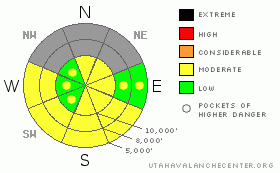
Danger Rose Tutorial
|
We have a localized MODERATE for fresh and lingering wind drifts from the sustained northwesterly winds. They’ve been strong for nearly a week now. We have an isolated MODERATE danger for triggering a deep slab avalanche in north through east facing terrain at the mid and upper elevations. Wet activity will increase with the solar warming by late morning. Avoid the steep sunny exits by early afternoon. |
|
|
CURRENT CONDITIONS |

|
The velvet blanket of stratus now long gone, skies are again clear and inversions are beginning to take hold. Temps are in the mid to upper twenties. I trust that this will be the northwesterly winds’ last gasp, before fizzling out under the advancing dome of high pressure. They’re still humming along at 20-25mph and gusting to 30, but, again, confined to the highest elevations. Certainly, the moist northwesterly flow and winds rimed and damaged most of the terrain, but you can find soft settled powder at the sheltered mid and low elevations. The rime crust is from Ogden to Park City and the Salt Lake mountains and more pronounced on the mid and upper elevation windward aspects. |
|
|
RECENT ACTIVITY |

|
We heard of no activity in the Provo mountains. Activity in the central Wasatch amounted to some very minor wet rollerballs on the sunnyside and a couple explosive-induced shallow hard slabs. DOT in Big Cottonwood Canyon spotted a couple new wind pockets that released high in northeast facing Stairs Gulch – high, lonely, steep, rocky windswept terrain. |
|
|
THREAT #1 |

|
| WHERE |
PROBABILITY |
SIZE |
TREND |

|
|
|
|
| |
|
|
Over the next
24 hours.
|
|
|
Most, but not all, of the drifts are pretty well welded into place. Still, good habits save lives, and it’s still worth a bit of caution or a well-executed cut across the top of the slope before committing to anything. |
|
|
THREAT #2 |

|
| WHERE |
PROBABILITY |
SIZE |
TREND |
|
|
|
|
| |
|
|
Over the next
24 hours.
|
|
|
Now that the weather’s favorable and the deep slab hysteria is more of a muffle than a shout, it’s likely that folks will start pushing into more of the supertour/radical terrain. If you’re heading this way, take note of the patterns from the unrelenting winds, yesterday’s naturals in upper Stairs, and the terrain distribution of the lingering deep slab instability. Most pit profiles and on-snow tests have pointed toward a somewhat healing snowpack, but few have tested the high, lonely, steep, rocky, windswept terrain. If you’re heading into this terrain over the next few days, you’ll assume the same risk – best to follow strict protocol – ride one at a time, get out of the way at the bottom, make a plan. |
|
|
THREAT #3 |

|
| WHERE |
PROBABILITY |
SIZE |
TREND |

|
|
|
|
|
|
We have a localized MODERATE for fresh and lingering wind drifts from the sustained northwesterly winds. They’ve been strong for nearly a week now. We have an isolated MODERATE danger for triggering a deep slab avalanche in north through east facing terrain at the mid and upper elevations. Wet activity will increase with the solar warming by late morning -watch your timing on those steep sunny exits. |
|
|
MOUNTAIN WEATHER |

|
Bluebird high under the building high pressure. Winds should start to relent some by the afternoon and blow 20-25mph from the north. 8000’ and 10,000’ temps will rise to the low thirties and upper twenties, respectively. High pressure and a building inversion will take hold through at least the weekend, with the weather models in some agreement on a transition to more storms for later next week. |
|
|
GENERAL ANNOUNCEMENTS |
Yesterday, Wasatch Powderbird Guides' operations page is here.
The Utah Avalanche Center is hosting a Level 2 avalanche class in February which is now open for registration by going to the Black Diamond retail store. More information is found off our education and calendar on the home page.
Beacon training parks are up and running! On the Park City side, there is one at the top of Canyon’s gondola, in Little Cottonwood one is near the Snowbird parking structure on the bypass road, and in Big Cottonwood a training park is at the west end of Solitude's lower parking lot.
If you want to get this avalanche advisory e-mailed to you daily click HERE.
UDOT highway avalanche control work info can be found by calling (801) 975-4838. Our statewide toll free line is 1-888-999-4019 (early morning, option 8).
The UAC depends on contributions from users like you to support our work. To find out more about how you can support our efforts to continue providing the avalanche forecasting and education that you expect please visit our Friends page.
Your snow and avalanche observations help everyone in the backcountry community. Please let us know what you're seeing by leaving a message at (801) 524-5304 or 1-800-662-4140, or email us at uac@utahavalanchecenter.org. (Fax 801-524-6301).
Ev will update this advisory by 7:30 tomorrow morning. |
|
|
This information does not apply to developed ski areas or highways where avalanche control is normally done. This advisory is from the U.S.D.A. Forest Service, which is solely responsible for its content. This advisory describes general avalanche conditions and local variations always occur. |
|
This advisory provided by the USDA Forest Service, in partnership with:
The Friends of the Utah Avalanche Center, Utah Division of State Parks and Recreation, Utah Division of Emergency Management, Salt Lake County, Salt Lake Unified Fire Authority and the friends of the La Sal Avalanche Center. See our Sponsors Page for a complete list. |
